Southwest Tasmania by Kayak
Located deep in the Tasmanian Wilderness World Heritage Area (TWWHA), with the closest road around 50km north and a host of mountains and boggy scrub in between, this is a place that requires considerable planning and expertise to explore.
While light planes can land on the small quartzite airstrip at Melaleuca, and it is possible to hike in via the Port Davey and South Coast Tracks, to properly explore this remote area, a boat is required. A kayak is the ideal vessel for such a task.
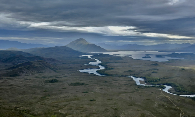
If you were to head in a straight line west the next body of land you would meet would be the east coast of Argentina over 15,000km away, while if you headed south, you would next bump into Antarctica.
The Geographical location combined with the surrounding mountainous terrain is responsible for the rapidly changing and often challenging weather experienced in Southwest Tasmania. Here it is the norm to go from clear blue skies and glassy waters one moment, to rain and strong winds the next. The dominant wind direction here is from the southwest, and rain and wind will often come in short, localised squalls that are blown in from the Southern Ocean. While the weather may deteriorate rapidly, it will often improve just as quickly. This everchanging weather cycle makes adaptability key when exploring the Southwest.
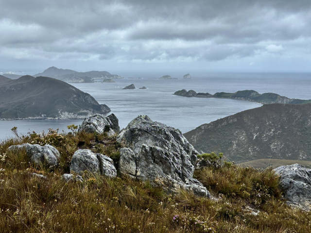
If you were to head in a straight line west the next body of land you would meet would be the east coast of Argentina over 15,000km away, while if you headed south, you would next bump into Antarctica.
One of the things that make the region so attractive to kayakers is the extensive range of bays, inlets, rivers, and islands available to explore. Connecting Port Davey on the oceanside to Bathurst Harbour is the Bathurst Channel. The channel is protected from the ocean swell by the Breaksea Islands, a strip of quartzite islands that sit around 1km west of the mouth of the channel. In the right conditions, kayaking around the outside of these islands is one of the highlights of an expedition to Port Davey. The islands also give you a good example of how rough the conditions can be in the area, with one section of them eroding away, where, during storms, the waves and swell crash over them.
On the occasion that the swell is small enough to paddle right up to the coastline of both the Breakseas and the mainland, large sea caves hide themselves amongst the jagged cliffs waiting for those that take the time to find them.
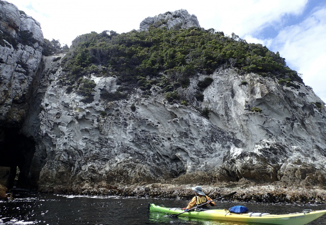
One of the things that make the region so attractive to kayakers is the extensive range of bays, inlets, rivers, and islands
While Bathurst Harbour and the surrounding hills and mountains bring to mind terrain that is typical of Southwest Tasmania, Port Daveys quartzite islands and white, sandy beaches bring to mind something closer to the Mediterranean.
When kayaking in the region, planning is essential, as while the weather may allow you to get somewhere, you must also be confident that the wind will let you get back. As there is no phone reception in the area, having access to regular, detailed weather reports via a satellite phone or similar device is essential.
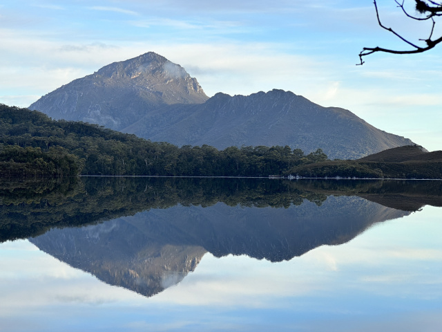
For days when being on water is not appropriate, or you just feel like observing the surroundings from a different aspect, there are various hiking trails that can only be accessed by water. These include trails up Mount Stokes or Mount Milner for views over Port Davey, up Mount Beatie to survey Bathurst Harbour and the channel, or the highest peak on the shores of Bathurst Harbour, Mount Rugby.
The safest and most logistically friendly option is to join a multi-day guided tour of the region. I have, however, also come across people kayaking self-supported after having brought in a kayak on a yacht or fishing boat, and the occasional group who have paddled in either down the west coast from Strahan or around the south coast from Cockle Creek.
Any attempt of kayaking self-supported in this region should only be attempted by advanced kayakers with the appropriate gear and safety equipment, who have a thorough understanding of how the weather affects you as a kayaker, and the dominant weather patterns in the region.
On the occasion that the swell is small enough to paddle right up to the coastline of both the Breakseas and the mainland, large sea caves hide themselves amongst the jagged cliffs waiting for those that take the time to find them.
Mischa Cushing
Outdoor educator and sea kayak guide.
Located deep in the Tasmanian Wilderness World Heritage Area (TWWHA), with the closest road around 50km north and a host of mountains and boggy scrub in between, this is a place that requires considerable planning and expertise to explore.
While light planes can land on the small quartzite airstrip at Melaleuca, and it is possible to hike in via the Port Davey and South Coast Tracks, to properly explore this remote area, a boat is required. A kayak is the ideal vessel for such a task.

If you were to head in a straight line west the next body of land you would meet would be the east coast of Argentina over 15,000km away, while if you headed south, you would next bump into Antarctica.
The Geographical location combined with the surrounding mountainous terrain is responsible for the rapidly changing and often challenging weather experienced in Southwest Tasmania. Here it is the norm to go from clear blue skies and glassy waters one moment, to rain and strong winds the next. The dominant wind direction here is from the southwest, and rain and wind will often come in short, localised squalls that are blown in from the Southern Ocean. While the weather may deteriorate rapidly, it will often improve just as quickly. This everchanging weather cycle makes adaptability key when exploring the Southwest.

If you were to head in a straight line west the next body of land you would meet would be the east coast of Argentina over 15,000km away, while if you headed south, you would next bump into Antarctica.
One of the things that make the region so attractive to kayakers is the extensive range of bays, inlets, rivers, and islands available to explore. Connecting Port Davey on the oceanside to Bathurst Harbour is the Bathurst Channel. The channel is protected from the ocean swell by the Breaksea Islands, a strip of quartzite islands that sit around 1km west of the mouth of the channel. In the right conditions, kayaking around the outside of these islands is one of the highlights of an expedition to Port Davey. The islands also give you a good example of how rough the conditions can be in the area, with one section of them eroding away, where, during storms, the waves and swell crash over them.
On the occasion that the swell is small enough to paddle right up to the coastline of both the Breakseas and the mainland, large sea caves hide themselves amongst the jagged cliffs waiting for those that take the time to find them.

One of the things that make the region so attractive to kayakers is the extensive range of bays, inlets, rivers, and islands
While Bathurst Harbour and the surrounding hills and mountains bring to mind terrain that is typical of Southwest Tasmania, Port Daveys quartzite islands and white, sandy beaches bring to mind something closer to the Mediterranean.
When kayaking in the region, planning is essential, as while the weather may allow you to get somewhere, you must also be confident that the wind will let you get back. As there is no phone reception in the area, having access to regular, detailed weather reports via a satellite phone or similar device is essential.
For days when being on water is not appropriate, or you just feel like observing the surroundings from a different aspect, there are various hiking trails that can only be accessed by water. These include trails up Mount Stokes or Mount Milner for views over Port Davey, up Mount Beatie to survey Bathurst Harbour and the channel, or the highest peak on the shores of Bathurst Harbour, Mount Rugby.

The safest and most logistically friendly option is to join a multi-day guided tour of the region. I have, however, also come across people kayaking self-supported after having brought in a kayak on a yacht or fishing boat, and the occasional group who have paddled in either down the west coast from Strahan or around the south coast from Cockle Creek.
Any attempt of kayaking self-supported in this region should only be attempted by advanced kayakers with the appropriate gear and safety equipment, who have a thorough understanding of how the weather affects you as a kayaker, and the dominant weather patterns in the region.
On the occasion that the swell is small enough to paddle right up to the coastline of both the Breakseas and the mainland, large sea caves hide themselves amongst the jagged cliffs waiting for those that take the time to find them.
You might like...

International River Grading System

Flatwater Grades
Kayaking
Dennes Point to Bligh Point
2-3 hours, 4 hours to include Cape De La Sortie return
10km return + another 3-4km return to extend the trip to Cape De La Sortie return
Takayna / Tarkine
takayna/Tarkine is the southern Hemisphere's largest temperate rainforest, a vast expanse of wild country encompassing spectacular coastline, wild rivers, mountains, waterfalls and open heathland and plains
Newsletter
Sign up to keep in touch with articles, updates, events or news from Kuno, your platform for nature
