 Beta
Beta
International River Grading System
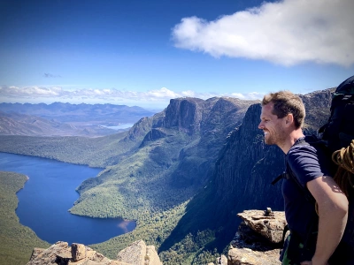
“The first river you paddle runs through the rest of your life. It bubbles up in pools and eddies to remind you who you are.” – Lynn Culbreath Noel
This explanation of the International River Grading System is taken directly from the Australian Canoeing Safety Guidelines (Appendix B, 2012)
The International River Grading System has been designed to provide an indication of the degree of difficulty for paddling of a rapid and/or river. It is not an absolute scale and should be used with the understanding that the scale does not indicate the full extent of hazards that may be encountered on a river:
- The degree of remoteness, overhanging trees and other elements that add risk to the trip that aren’t actually part of the river, are not accounted for in this system
- Rivers tend to be graded by the grade of the majority of the rapids they contain, but there may be one or two much harder rapids on the river
- The skills needed to paddle, for example, technical Grade 4 rivers are very different from the skills needed to paddle big volume Grade 4 rivers
- It should be remembered that the higher the grading the greater the risks involved in swimming
- Paddling one very difficult rapid, say Grade 4, presents a different level of risk than paddling an entire river of continuous Grade 4 rapids
- The degree of difficulty of rivers can change significantly at different water levels
- Slight variations in the interepretation of the grading will exist in each local region according to the nature of the rivers found there.
Experienced local paddlers are the best source of information about rivers. The following descriptions are a basic guide to each grade.
Grade 1: Easy: Slow to medium flowing water with very small, regular waves or riffles. Relatively few obstacles, with an easy path to find and follow. Suitable for novices.
Grade 2: Medium: Rapids are straightforward with medium sized, regular waves. The path through rapids can be clearly seen from the water and is often indicated by well-defined chutes or Vs of water. There are some obstacles that require manoeuvring around, but paddlers with a good command of basic strokes can easily miss them.
Grade 3: Difficult: Rapids have moderate, irregular waves and strong currents. Manoeuvring is required to follow the preferred route. Small to medium sized stoppers may have to be negotiated. The route is difficult for inexperienced paddlers to see and scouting is advisable. Suitable for experienced Whitewater paddlers, with the ability to roll an advantage.
Grade 4: Advanced: Rapids have large waves and powerful, confused currents. Drops are big and stoppers can be large and unavoidable. Fast manoeuvres may need to be made. The route is not clear, and scouting may be needed. Suitable only for very experienced Whitewater paddlers with consistent skills and reliable rolls.
Grade 5: Expert: Extremely long, obstructed or powerful rapids. Rapids may contain very large unavoidable drops, waves, and stoppers and turbulent, unpredictable currents. Fast and accurate manoeuvring is necessary. Eddies may be very small, turbulent and scarce. The route is complex and scouting is highly recommended. Suitable only for expert paddlers, who are willing to accept the higher level of risk. Rolling in adverse conditions is essential. Swimming is very dangerous.
Grade 6: Extreme: Rapids are extremely technically difficult, powerful and unpredictable. They are rarely paddled, and if they are paddled successfully they are usually downgraded to Grade 5 plus. The river cannot be paddled without severe risk to life.
For more information Kayaking in Tasmania, visit Paddle Tas

Phill Pullinger
“The first river you paddle runs through the rest of your life. It bubbles up in pools and eddies to remind you who you are.” – Lynn Culbreath Noel
This explanation of the International River Grading System is taken directly from the Australian Canoeing Safety Guidelines (Appendix B, 2012)
The International River Grading System has been designed to provide an indication of the degree of difficulty for paddling of a rapid and/or river. It is not an absolute scale and should be used with the understanding that the scale does not indicate the full extent of hazards that may be encountered on a river:
- The degree of remoteness, overhanging trees and other elements that add risk to the trip that aren’t actually part of the river, are not accounted for in this system
- Rivers tend to be graded by the grade of the majority of the rapids they contain, but there may be one or two much harder rapids on the river
- The skills needed to paddle, for example, technical Grade 4 rivers are very different from the skills needed to paddle big volume Grade 4 rivers
- It should be remembered that the higher the grading the greater the risks involved in swimming
- Paddling one very difficult rapid, say Grade 4, presents a different level of risk than paddling an entire river of continuous Grade 4 rapids
- The degree of difficulty of rivers can change significantly at different water levels
- Slight variations in the interepretation of the grading will exist in each local region according to the nature of the rivers found there.
Experienced local paddlers are the best source of information about rivers. The following descriptions are a basic guide to each grade.
Grade 1: Easy: Slow to medium flowing water with very small, regular waves or riffles. Relatively few obstacles, with an easy path to find and follow. Suitable for novices.
Grade 2: Medium: Rapids are straightforward with medium sized, regular waves. The path through rapids can be clearly seen from the water and is often indicated by well-defined chutes or Vs of water. There are some obstacles that require manoeuvring around, but paddlers with a good command of basic strokes can easily miss them.
Grade 3: Difficult: Rapids have moderate, irregular waves and strong currents. Manoeuvring is required to follow the preferred route. Small to medium sized stoppers may have to be negotiated. The route is difficult for inexperienced paddlers to see and scouting is advisable. Suitable for experienced Whitewater paddlers, with the ability to roll an advantage.
Grade 4: Advanced: Rapids have large waves and powerful, confused currents. Drops are big and stoppers can be large and unavoidable. Fast manoeuvres may need to be made. The route is not clear, and scouting may be needed. Suitable only for very experienced Whitewater paddlers with consistent skills and reliable rolls.
Grade 5: Expert: Extremely long, obstructed or powerful rapids. Rapids may contain very large unavoidable drops, waves, and stoppers and turbulent, unpredictable currents. Fast and accurate manoeuvring is necessary. Eddies may be very small, turbulent and scarce. The route is complex and scouting is highly recommended. Suitable only for expert paddlers, who are willing to accept the higher level of risk. Rolling in adverse conditions is essential. Swimming is very dangerous.
Grade 6: Extreme: Rapids are extremely technically difficult, powerful and unpredictable. They are rarely paddled, and if they are paddled successfully they are usually downgraded to Grade 5 plus. The river cannot be paddled without severe risk to life.
For more information Kayaking in Tasmania, visit Paddle Tas
Love what you're reading? Support Kuno donate to support them now
Donate hereYou might like...

Curious and creative Nature play

It started rescuing animals in Ghana

Bruny Island launch: Bob Graham on the hidden world behind the photos
Restoring Sydney Harbour's marine biodiversity with Brett Fenton
Newsletter
Sign up to keep in touch with articles, updates, events or news from Kuno, your platform for nature