
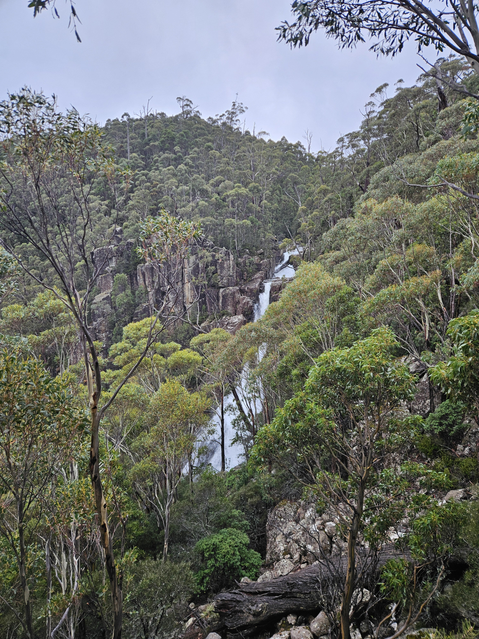
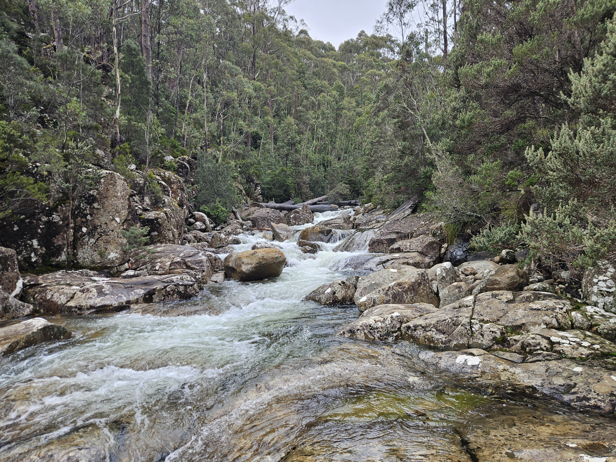
A stunning day walk with great views and a range of plant and bird life culminating at Wellington Falls, which flows into the Northwest Bay River.
Highlights
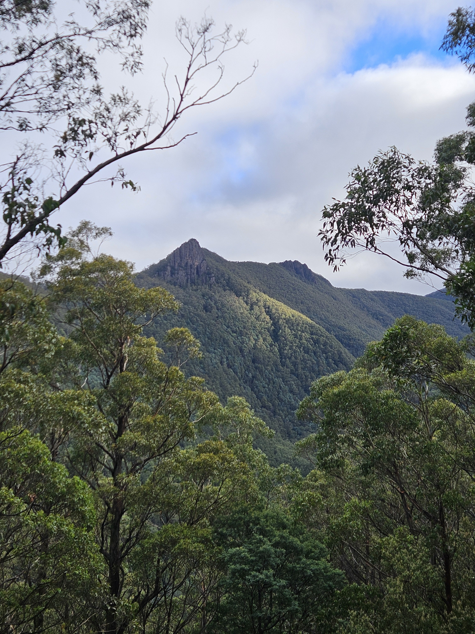
Wellington Falls, wet forest and sub-alpine flora, varied track types and views of Cathedral Rock.
Nature
Park size: 18,011 hectares
Natural features
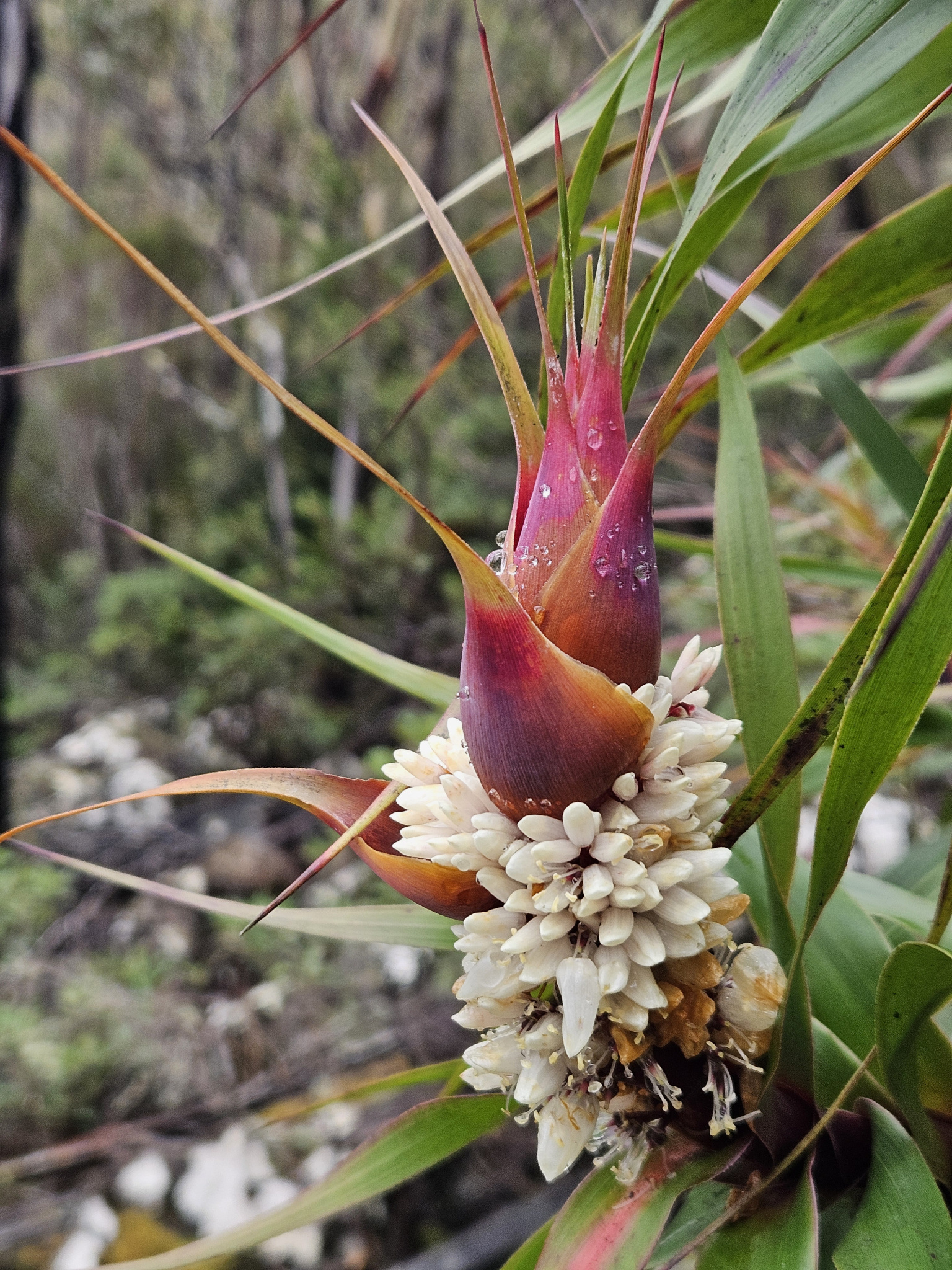
Fern Trees, dragon heath (Richea Dracophylla), bird life, and dolerite cliffs.
Conservation
Kunanyi/Mt Wellington is a known breeding ground for the critically endangered Swift Parrot (Lathamus discolor) and is also home to the endangered Tasmanian Masked Owl (Tyto novaehollandiae castanops), Wedge-tailed Eagle (Aquila audax fleayi) and Tasmanian Devil (Sarcophilus harrisii).
Feral cats are a threat to biodiversity within the park, as are other Introduced species including the Superb Lyrebird (Menura novaehollandiae).
Track details
Starting at the car park on the corner of Morphetts Road, cross the road and begin making your way up the hill. The first section of this track is mixed use, and you can therefore complete it as either a hike, or you can cycle the first section before walking the final track up to Wellington Falls.
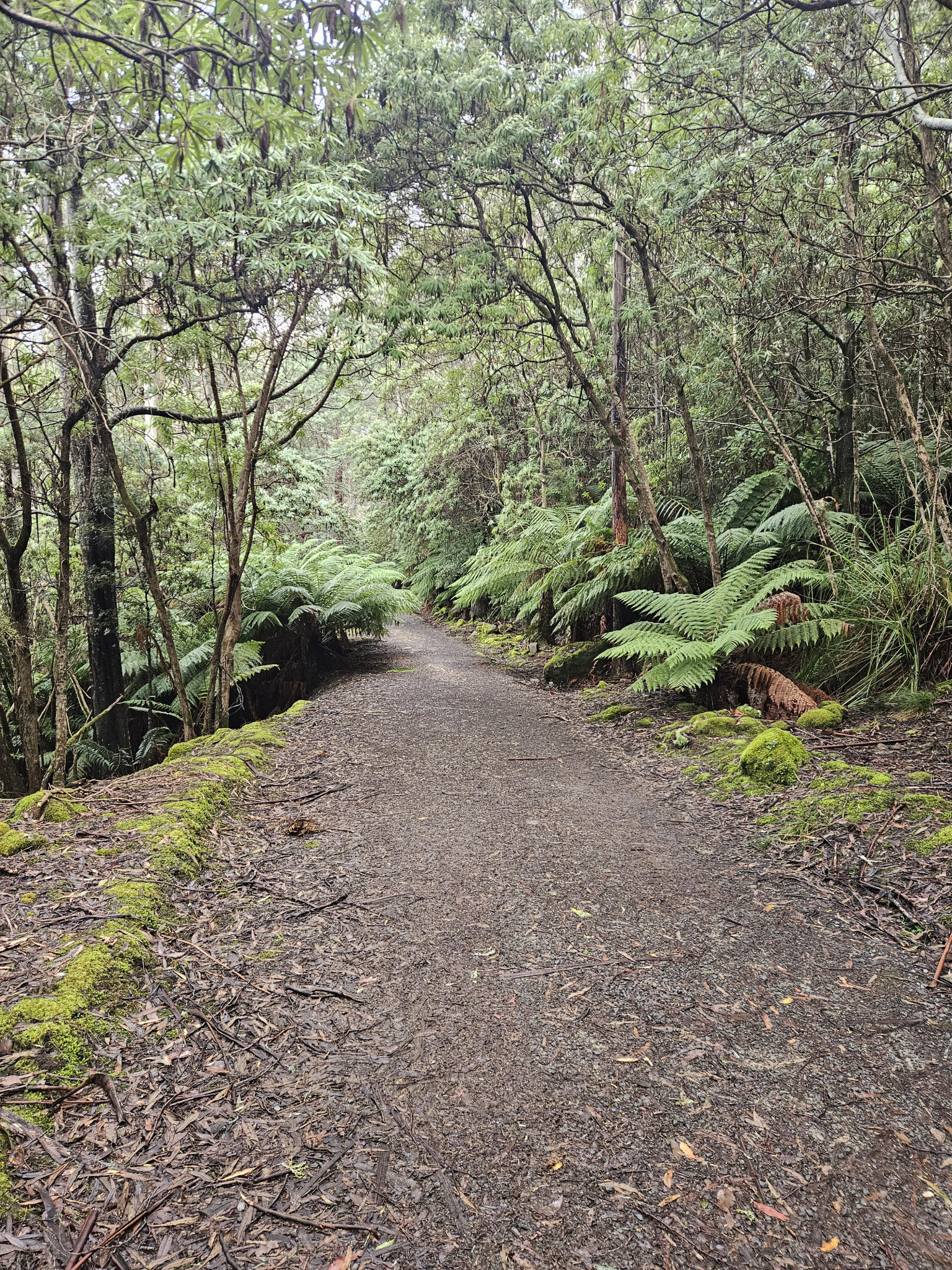
The trail starts of quite steep for a short distance, before it meets the Pipeline Track and begins to flatten out. Here you will see a sign for Wellington Falls. Continue along this track for the next 6.78km. This section of the trail is relatively flat with some slight inclines. Along the way you will pass several small waterfalls and streams, which, depending on rainfall levels, may be flowing across the track. The streams are all small enough to step or jump over, however, caution should be taken so as not to slip.
Wet eucalyptus forest surrounds the track, and there are a large number of fern trees lining sections of the trail. Unless there is low cloud cover, you will also get some excellent views looking out across the valley towards Cathedral Rock, with the Montagu Thumbs off to its right.
After around two hours, you will come to a bike rack where you can lock your bike if you have ridden so far. Otherwise, continue for a few metres around the corner, and you will come to a smaller track on your right, that leads up to Wellington Falls.
This section of the track is around 2.2km and is uphill most of the way to the falls. You will begin to see more sub-alpine flora, including the distinctive dragon heath (Richea dracophylla). After walking for around 40 minutes, you will reach a split in the trail. By this stage, you will be able to hear the falls. There are multiple signposts and trails here, with one off to your left that leads a short distance down to a lookout that is the best viewing point of Wellington Falls. At the lookout. If you are after somewhere for lunch or a snack, either the bench at the lookout or the rocks by the side of the river at the top of the falls are both good spots.
To reach the top of the falls, continue along the main trail for around another 20 metres uphill, before reaching a track that heads off to your left. While this is an official trail, this turnoff is not signposted. If you have children with you, ensure they do not go ahead of you, as there is fast moving water and unfenced cliff edges at the end of the trail.
This section of the track requires some care, as you will make your way over rocks which can be slippery after rain, and some sections of the track can be harder to distinguish, especially if there is snow around. After a short distance you will come out at the river just above Wellington Falls. There are some large boulders at the river’s edge which are another good spot for lunch or a snack.
Once you have finished having a look around, make your way back the way you came along the Wellington Falls Track, before joining the Pipeline Track and heading back to the trailhead.
Conditions
Weather conditions within Wellington Park can change rapidly, potentially bringing high winds, rain, and snow, even in summer. Check local weather forecasts before attempting any walks in Wellington Park. Also be aware that roads may be closed on certain days during winter due to icy roads and snow cover.
Ensure you have appropriate sun protection, as UV radiation is stronger in high altitude areas, such as on mountains. The fire danger rating for the area should also be checked. Be aware that Wellington Park is closed on days with a fire danger rating of Extreme or Catastrophic in the Upper Derwent Valley or South East districts.
For up to date weather forecasting on Kunanyi/Mount Wellington, refer to: http://www.bom.gov.au/tas/forecasts/mtwellington.shtml
Safety advice
There are unfenced cliff faces and fast-moving water around Wellington Falls, and a high level of caution is required. Rocks and boulders may be slippery and approaching cliff edges is not advised.
Ensure you are appropriately prepared for mountain weather conditions, and have warm clothing, a waterproof jacket, sturdy walking boots, and food and water.
Weather conditions can change rapidly within the area, with freezing temperatures occurring regularly.
Hikers should also be aware of the possibility of bushfires as this is a forested environment.
During spring, summer and autumn, be aware that snakes may be active in the area. If encountered, move away from them slowly.
If you are injured and require emergency medical attention, call 000.
For further information on bushfires in Tasmania, refer to: https://www.fire.tas.gov.au/
Age restrictions and advice
While a large portion of this walk is relatively flat, it is a long walk and is therefore not appropriate for small children. Adult supervision of children is required at all times when in the vicinity of Wellington Falls, as there are multiple unfenced cliff edges, slippery rocks and fast-moving water.
Location
Pipeline Track, Neika Tasmania 7054, Australia
From Hobart, drive up Davey Street, which later becomes Huon Road. Continue around 16km past the Southern Outlet intersection to the corner of Morphetts Road, where you will find a small car park. The trail head is across the road from the car park.
Nature
Park size: 18,011 hectares
Natural features
Fern Trees, dragon heath (Richea Dracophylla), bird life, and dolerite cliffs.
Conservation
Kunanyi/Mt Wellington is a known breeding ground for the critically endangered Swift Parrot (Lathamus discolor) and is also home to the endangered Tasmanian Masked Owl (Tyto novaehollandiae castanops), Wedge-tailed Eagle (Aquila audax fleayi) and Tasmanian Devil (Sarcophilus harrisii).
Feral cats are a threat to biodiversity within the park, as are other Introduced species including the Superb Lyrebird (Menura novaehollandiae).
Track details
Starting at the car park on the corner of Morphetts Road, cross the road and begin making your way up the hill. The first section of this track is mixed use, and you can therefore complete it as either a hike, or you can cycle the first section before walking the final track up to Wellington Falls.
The trail starts of quite steep for a short distance, before it meets the Pipeline Track and begins to flatten out. Here you will see a sign for Wellington Falls. Continue along this track for the next 6.78km. This section of the trail is relatively flat with some slight inclines. Along the way you will pass several small waterfalls and streams, which, depending on rainfall levels, may be flowing across the track. The streams are all small enough to step or jump over, however, caution should be taken so as not to slip.
Wet eucalyptus forest surrounds the track, and there are a large number of fern trees lining sections of the trail. Unless there is low cloud cover, you will also get some excellent views looking out across the valley towards Cathedral Rock, with the Montagu Thumbs off to its right.
After around two hours, you will come to a bike rack where you can lock your bike if you have ridden so far. Otherwise, continue for a few metres around the corner, and you will come to a smaller track on your right, that leads up to Wellington Falls.
This section of the track is around 2.2km and is uphill most of the way to the falls. You will begin to see more sub-alpine flora, including the distinctive dragon heath (Richea dracophylla). After walking for around 40 minutes, you will reach a split in the trail. By this stage, you will be able to hear the falls. There are multiple signposts and trails here, with one off to your left that leads a short distance down to a lookout that is the best viewing point of Wellington Falls. At the lookout. If you are after somewhere for lunch or a snack, either the bench at the lookout or the rocks by the side of the river at the top of the falls are both good spots.
To reach the top of the falls, continue along the main trail for around another 20 metres uphill, before reaching a track that heads off to your left. While this is an official trail, this turnoff is not signposted. If you have children with you, ensure they do not go ahead of you, as there is fast moving water and unfenced cliff edges at the end of the trail.
This section of the track requires some care, as you will make your way over rocks which can be slippery after rain, and some sections of the track can be harder to distinguish, especially if there is snow around. After a short distance you will come out at the river just above Wellington Falls. There are some large boulders at the river’s edge which are another good spot for lunch or a snack.
Once you have finished having a look around, make your way back the way you came along the Wellington Falls Track, before joining the Pipeline Track and heading back to the trailhead.
Conditions
Weather conditions within Wellington Park can change rapidly, potentially bringing high winds, rain, and snow, even in summer. Check local weather forecasts before attempting any walks in Wellington Park. Also be aware that roads may be closed on certain days during winter due to icy roads and snow cover.
Ensure you have appropriate sun protection, as UV radiation is stronger in high altitude areas, such as on mountains. The fire danger rating for the area should also be checked. Be aware that Wellington Park is closed on days with a fire danger rating of Extreme or Catastrophic in the Upper Derwent Valley or South East districts.
For up to date weather forecasting on Kunanyi/Mount Wellington, refer to: http://www.bom.gov.au/tas/forecasts/mtwellington.shtml
Safety advice
There are unfenced cliff faces and fast-moving water around Wellington Falls, and a high level of caution is required. Rocks and boulders may be slippery and approaching cliff edges is not advised.
Ensure you are appropriately prepared for mountain weather conditions, and have warm clothing, a waterproof jacket, sturdy walking boots, and food and water.
Weather conditions can change rapidly within the area, with freezing temperatures occurring regularly.
Hikers should also be aware of the possibility of bushfires as this is a forested environment.
During spring, summer and autumn, be aware that snakes may be active in the area. If encountered, move away from them slowly.
If you are injured and require emergency medical attention, call 000.
For further information on bushfires in Tasmania, refer to: https://www.fire.tas.gov.au/
Age restrictions and advice
While a large portion of this walk is relatively flat, it is a long walk and is therefore not appropriate for small children. Adult supervision of children is required at all times when in the vicinity of Wellington Falls, as there are multiple unfenced cliff edges, slippery rocks and fast-moving water.
Location
Pipeline Track, Neika Tasmania 7054, Australia
From Hobart, drive up Davey Street, which later becomes Huon Road. Continue around 16km past the Southern Outlet intersection to the corner of Morphetts Road, where you will find a small car park. The trail head is across the road from the car park.