
A historic trail that passes several ice house ruins, which were used to store ice in the 1800s. The trail has excellent views of South Wellington as well as back out towards Hobart, and leads you into the windswept, alpine landscape at the southern end of the mountain.
Highlights
The Ice house ruins, sub alpine and alpine flora, dolerite boulder fields and excellent views.
Nature
Park size: 18,011 hectares
Natural features
Dragon heath (Richea dracophylla), Mountain pinkberry (Leptecophylla parvifolia), Pineapple Grass (Astelia alpina), Mountain Pepper Berry (Tasmannia lanceolata), wind swept Tasmanian snow gums (Eucalyptus coccifera) and Alpine yellow gum (Eucalyptus subcrenulata), dolerite boulder fields and frequent snow and ice.
Conservation
Kunanyi/Mt Wellington is a known breeding ground for the critically endangered Swift Parrot (Lathamus discolor) and is also home to the endangered Tasmanian Masked Owl (Tyto novaehollandiae castanops), Wedge-tailed Eagle (Aquila audax fleayi) and Tasmanian Devil (Sarcophilus harrisii).
Feral cats are a threat to biodiversity within the park, as are other Introduced species including the Superb Lyrebird (Menura novaehollandiae).
Track details
Starting from The Springs car park, cross the road near the café and toilets to the road opposite, Pinnacle Track Road, and follow it for a short distance before turning right on to the Radford Track. This will lead you up to the road again, where you will continue to your right for around 40 metres, to the start of the Pinnacle Track, which is signposted. After following the Pinnacle Track uphill for around 160 metres, you will come to another intersection. Take the left hand turn onto Gray’s Fire Trail, which you will follow for a little over 100m, before coming to a Y intersection. Take the top, right hand track to continue on to the Milles Track, which, after walking for another 200 metres, will take you to the Ice House Track on your right-hand side.
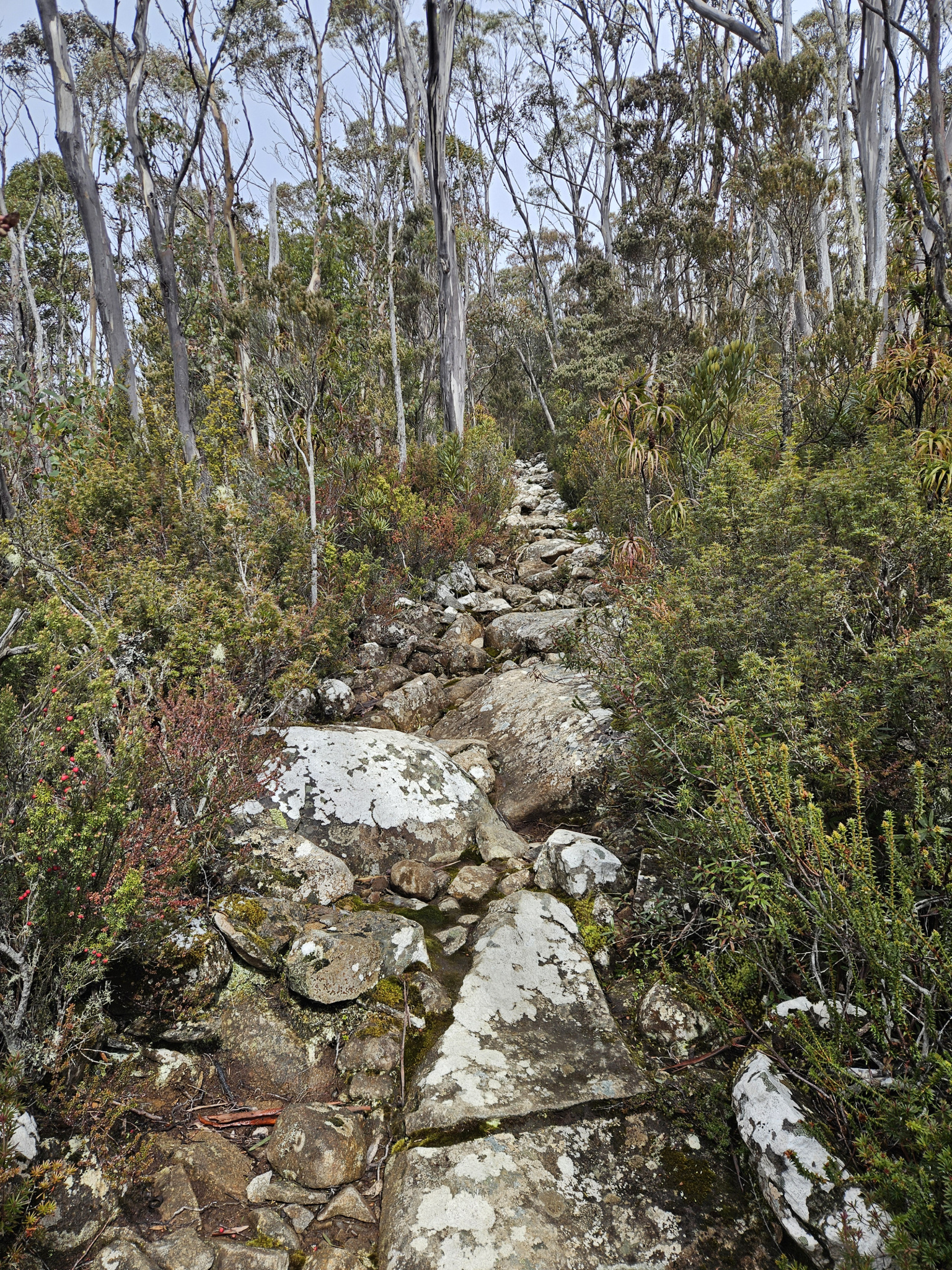
Taking this trail, you will begin to head uphill, into the forest.
As you make your way along, keep your eye out for the ruins of several ice houses that were located on this trail. You may also observe that as you get higher, sub-alpine species gradually become more prevalent such as dragon heath (Richea dracophylla) and mountain pinkberry (Leptecophylla parvifolia).
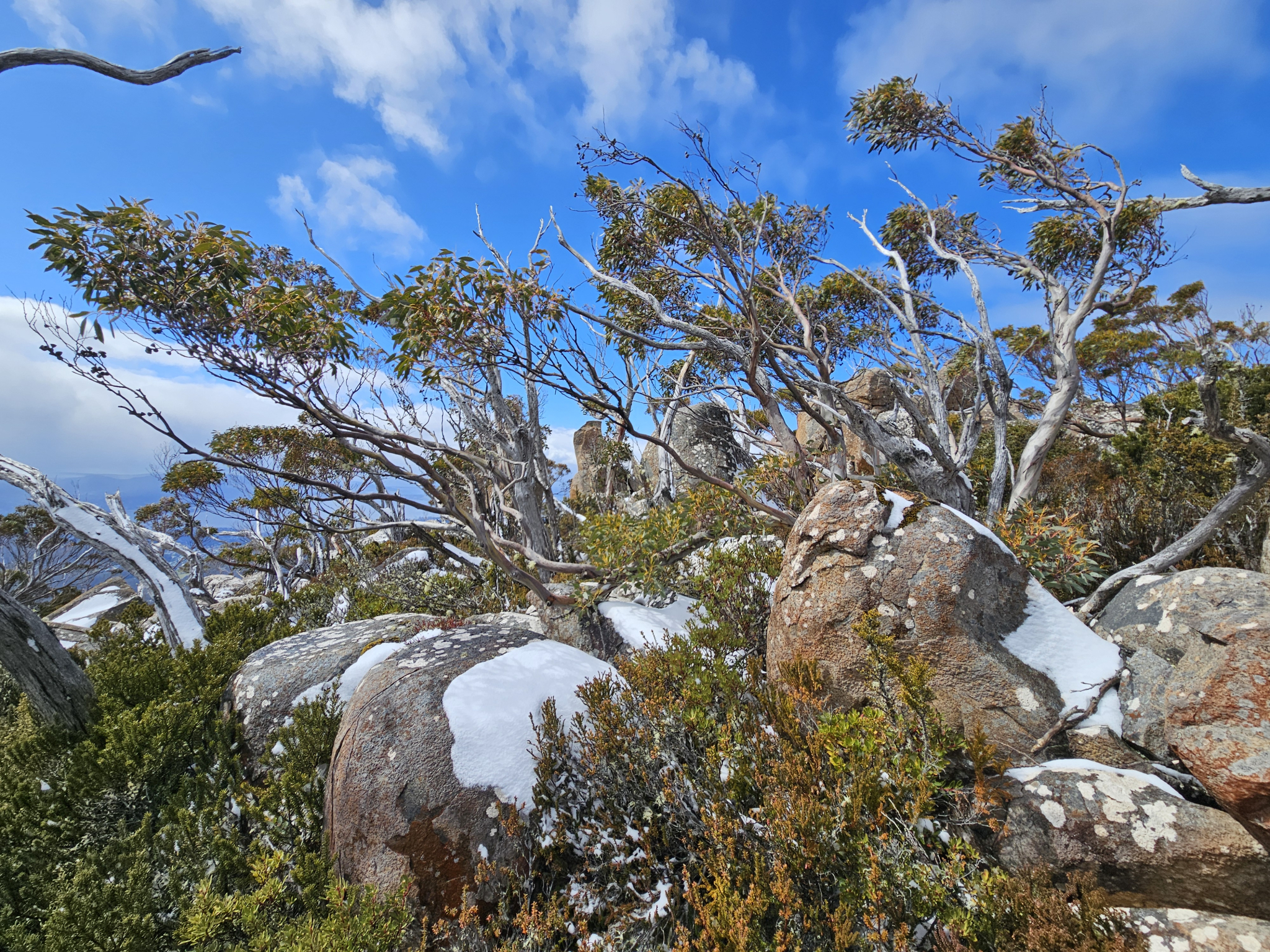
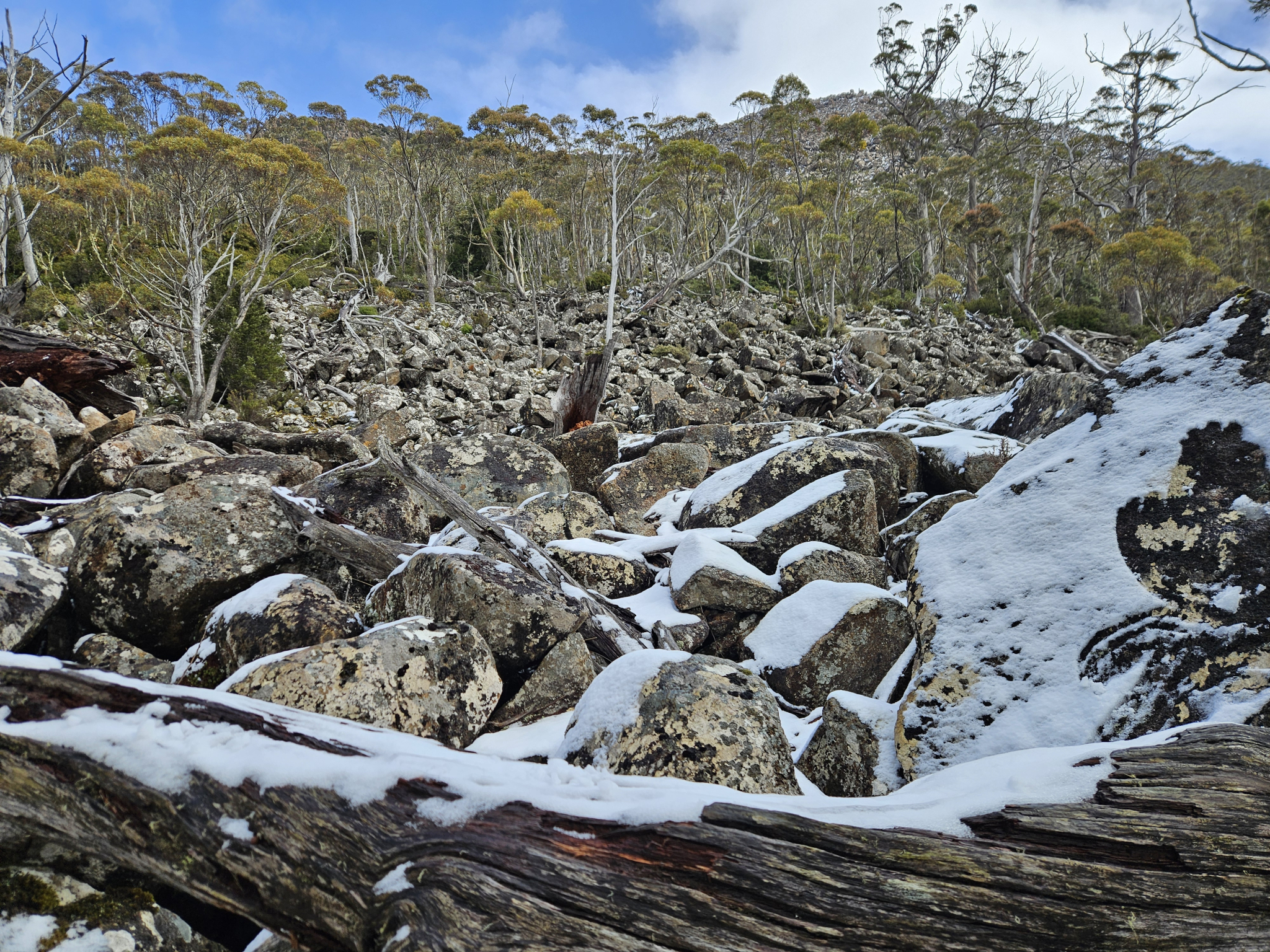
Gradually, the forest will begin to thin out as it becomes predominantly sub alpine eucalyptus species and small shrubs, which gradually giving way to Dolerite boulders fields.
Around 1.45km into the walk, a large boulder field opens up on your right, with the trail continuing to follow it on the left-hand side. Some impressive views of the edge of South Wellington also begin to open up looking past the boulder fields.
At around the 2.21km mark, you'll see a sign ensuring you are adequately prepared for your hike, as you're about to enter an alpine plateau that is very exposed to the wind, rain and snow, and can be considerably colder than what you have so far experienced.
While the trail is still obvious at this point, if there has been heavy snow, keep an eye out for the orange arrow markers directing you along the track.
As you come out into the higher regions, notice how the trees and shrubs are stunted from the harsh westerly winds. Once you reach this point, you will soon reach the end of the Ice House Track, which will become obvious as you will reach a track intersection, where two other trails meet with yours. If you wish to extend your walk, you can follow one of these tracks, which include the Smiths Monument track, and the South Wellington Track. For more information on these trails, please refer to their track guides.
Otherwise, once you have finished exploring the alpine landscape, return the way you came.
History
Name history
The Ice House Track is named after several ice houses which were located along the trail. Ice houses were used to store ice which was then sold on to confectioners and publicans prior to the invention of electric freezers. The first ice house on Kunanyi/Mt Wellington was commissioned by the current governor, Sir William Denison, in 1849, and was constructed by 20 convicts.
Place history
The ice house structures become disused and gradually forgotten during the 1890s. They were then later uncovered by the bushfires in 1967.
Conditions
Weather conditions within Wellington Park can change rapidly, potentially bringing high winds, rain, and snow, even in summer. Check local weather forecasts before attempting any walks in Wellington Park. Also be aware that roads may be closed on certain days during winter due to icy roads and snow cover.
Ensure you have appropriate sun protection, as UV radiation is stronger in high altitude areas, such as on mountains. The fire danger rating for the area should also be checked. Be aware that Wellington Park is closed on days with a fire danger rating of Extreme or Catastrophic in the Upper Derwent Valley or South East districts.
For up to date weather forecasting on Kunanyi/Mount Wellington, refer to: http://www.bom.gov.au/tas/forecasts/mtwellington.shtml
Safety advice
This trail takes you into an alpine environment that is extremely exposed to the elements and should not be attempted during storms, blizzards or other adverse weather events.
Ensure you are appropriately prepared for mountain weather conditions, and have warm clothing, a waterproof jacket, sturdy walking boots, and food and water.
Weather conditions can change rapidly within the area, with freezing temperatures occurring regularly.
Hikers should also be aware of the possibility of bushfires as this is a forested environment.
During spring, summer and autumn, be aware that snakes may be active in the area. If encountered, move away from them slowly.
Ensure you have told people which track you intend to take, and keep in mind that reception may not always be available on the trail.
If you are injured and require emergency medical attention, call 000.
For further information on bushfires in Tasmania, refer to: https://www.fire.tas.gov.au/
Age restrictions and advice
This is a strenuous, uphill walk that covers significant altitude over a short distance, and as such, is not suitable for young children
Location
Grays Fire Trail, Wellington Park Tasmania 7054, Australia
From Hobart, drive up Davey Street, which later becomes Huon Road. Continue around 7.2km past the Southern Outlet intersection before turning on to Pillinger Drive, which then becomes Pinnacle Road. From the turnoff, continue up the road for 4.1km, where you will reach The Springs. Here, you will find multiple car parks, however, it can be busy during holidays.
Alternatively, the Kunanyi/Mt Wellington Explorer Bus can be used to Access The Springs as well as other parts of the mountain, with more information provided here: https://mtwellingtonexplorer.com.au/
Nature
Park size: 18,011 hectares
Natural features
Dragon heath (Richea dracophylla), Mountain pinkberry (Leptecophylla parvifolia), Pineapple Grass (Astelia alpina), Mountain Pepper Berry (Tasmannia lanceolata), wind swept Tasmanian snow gums (Eucalyptus coccifera) and Alpine yellow gum (Eucalyptus subcrenulata), dolerite boulder fields and frequent snow and ice.
Conservation
Kunanyi/Mt Wellington is a known breeding ground for the critically endangered Swift Parrot (Lathamus discolor) and is also home to the endangered Tasmanian Masked Owl (Tyto novaehollandiae castanops), Wedge-tailed Eagle (Aquila audax fleayi) and Tasmanian Devil (Sarcophilus harrisii).
Feral cats are a threat to biodiversity within the park, as are other Introduced species including the Superb Lyrebird (Menura novaehollandiae).
Track details
Starting from The Springs car park, cross the road near the café and toilets to the road opposite, Pinnacle Track Road, and follow it for a short distance before turning right on to the Radford Track. This will lead you up to the road again, where you will continue to your right for around 40 metres, to the start of the Pinnacle Track, which is signposted. After following the Pinnacle Track uphill for around 160 metres, you will come to another intersection. Take the left hand turn onto Gray’s Fire Trail, which you will follow for a little over 100m, before coming to a Y intersection. Take the top, right hand track to continue on to the Milles Track, which, after walking for another 200 metres, will take you to the Ice House Track on your right-hand side.
Taking this trail, you will begin to head uphill, into the forest.
As you make your way along, keep your eye out for the ruins of several ice houses that were located on this trail. You may also observe that as you get higher, sub-alpine species gradually become more prevalent such as dragon heath (Richea dracophylla) and mountain pinkberry (Leptecophylla parvifolia).
Gradually, the forest will begin to thin out as it becomes predominantly sub alpine eucalyptus species and small shrubs, which gradually giving way to Dolerite boulders fields.
Around 1.45km into the walk, a large boulder field opens up on your right, with the trail continuing to follow it on the left-hand side. Some impressive views of the edge of South Wellington also begin to open up looking past the boulder fields.
At around the 2.21km mark, you'll see a sign ensuring you are adequately prepared for your hike, as you're about to enter an alpine plateau that is very exposed to the wind, rain and snow, and can be considerably colder than what you have so far experienced.
While the trail is still obvious at this point, if there has been heavy snow, keep an eye out for the orange arrow markers directing you along the track.
As you come out into the higher regions, notice how the trees and shrubs are stunted from the harsh westerly winds. Once you reach this point, you will soon reach the end of the Ice House Track, which will become obvious as you will reach a track intersection, where two other trails meet with yours. If you wish to extend your walk, you can follow one of these tracks, which include the Smiths Monument track, and the South Wellington Track. For more information on these trails, please refer to their track guides.
Otherwise, once you have finished exploring the alpine landscape, return the way you came.
History
Name history
The Ice House Track is named after several ice houses which were located along the trail. Ice houses were used to store ice which was then sold on to confectioners and publicans prior to the invention of electric freezers. The first ice house on Kunanyi/Mt Wellington was commissioned by the current governor, Sir William Denison, in 1849, and was constructed by 20 convicts.
Place history
The ice house structures become disused and gradually forgotten during the 1890s. They were then later uncovered by the bushfires in 1967.
Conditions
Weather conditions within Wellington Park can change rapidly, potentially bringing high winds, rain, and snow, even in summer. Check local weather forecasts before attempting any walks in Wellington Park. Also be aware that roads may be closed on certain days during winter due to icy roads and snow cover.
Ensure you have appropriate sun protection, as UV radiation is stronger in high altitude areas, such as on mountains. The fire danger rating for the area should also be checked. Be aware that Wellington Park is closed on days with a fire danger rating of Extreme or Catastrophic in the Upper Derwent Valley or South East districts.
For up to date weather forecasting on Kunanyi/Mount Wellington, refer to: http://www.bom.gov.au/tas/forecasts/mtwellington.shtml
Safety advice
This trail takes you into an alpine environment that is extremely exposed to the elements and should not be attempted during storms, blizzards or other adverse weather events.
Ensure you are appropriately prepared for mountain weather conditions, and have warm clothing, a waterproof jacket, sturdy walking boots, and food and water.
Weather conditions can change rapidly within the area, with freezing temperatures occurring regularly.
Hikers should also be aware of the possibility of bushfires as this is a forested environment.
During spring, summer and autumn, be aware that snakes may be active in the area. If encountered, move away from them slowly.
Ensure you have told people which track you intend to take, and keep in mind that reception may not always be available on the trail.
If you are injured and require emergency medical attention, call 000.
For further information on bushfires in Tasmania, refer to: https://www.fire.tas.gov.au/
Age restrictions and advice
This is a strenuous, uphill walk that covers significant altitude over a short distance, and as such, is not suitable for young children
Location
Grays Fire Trail, Wellington Park Tasmania 7054, Australia
From Hobart, drive up Davey Street, which later becomes Huon Road. Continue around 7.2km past the Southern Outlet intersection before turning on to Pillinger Drive, which then becomes Pinnacle Road. From the turnoff, continue up the road for 4.1km, where you will reach The Springs. Here, you will find multiple car parks, however, it can be busy during holidays.
Alternatively, the Kunanyi/Mt Wellington Explorer Bus can be used to Access The Springs as well as other parts of the mountain, with more information provided here: https://mtwellingtonexplorer.com.au/
Key info
1 hour 45 minutes return
4.8km return
Grade 3: Difficult
Facilities
There are public toilets located at the start of this trail at The Springs, as well as a small cafe, however there are no facilities further along the walk.