
A rugged short walk that gives a great taste of Kunanyi’s sub-alpine environment.
Highlights
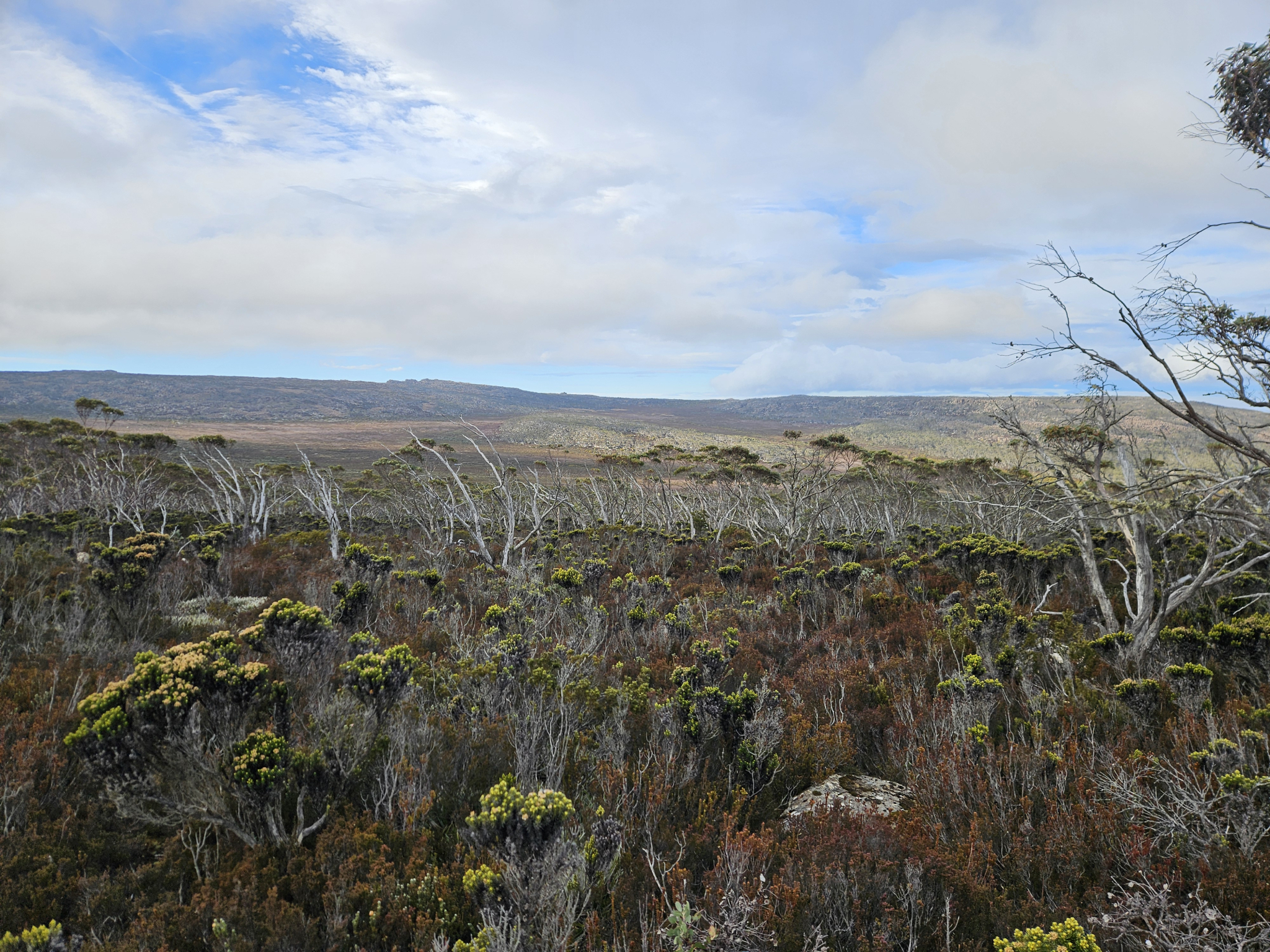
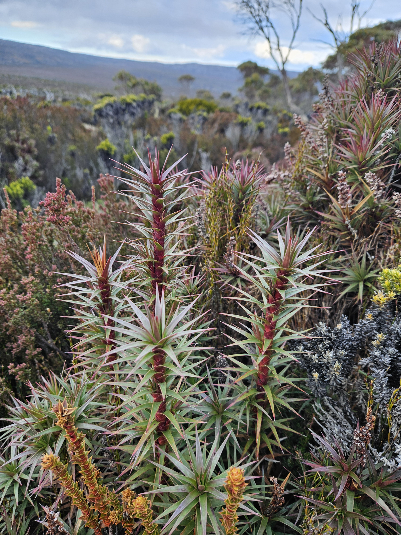
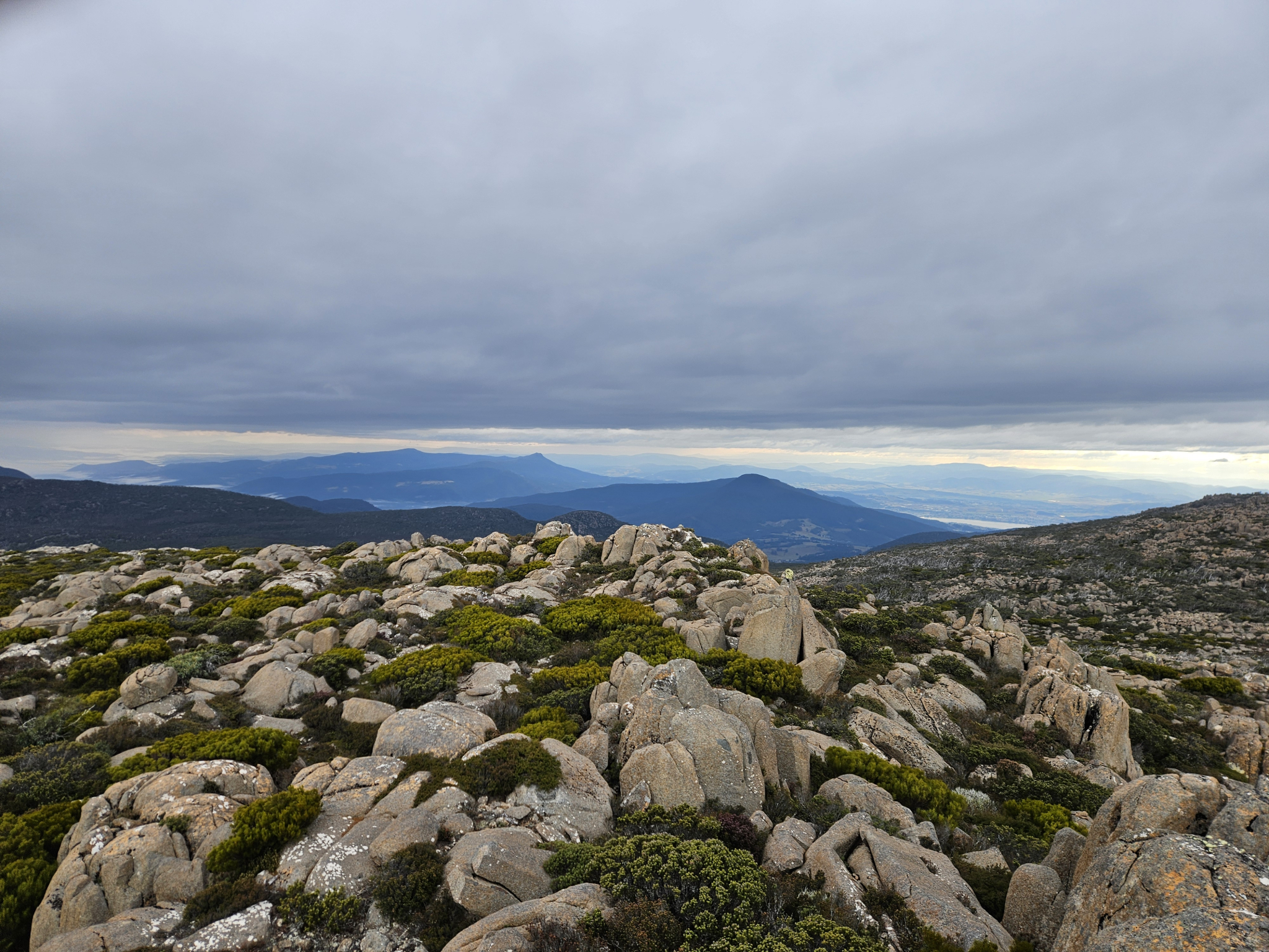
Rugged sub-alpine flora including the Tasmanian snow gum (Eucalyptus coccifera), Tasmanian Mountain Pepper (Tasmannia Lanceolata) and Richea scoparia, dolerite boulder fields, expansive views and a 100 metre off track section to the ridge.
Nature
Park size: 18,011 hectares
Natural features
Natural features along the way include Richea scoparia, Tasmanian Mountain Pepper (Tasmannia Lanceolata), Tasmanian snow gum (Eucalyptus coccifera), Alpine Yellow Gum (Eucalyptus subcrenulata) and large, lichen covered Dolerite boulder fields.
Conservation
Kunanyi/Mt Wellington is a known breeding ground for the critically endangered Swift Parrot (Lathamus discolor) and is also home to the endangered Tasmanian Masked Owl (Tyto novaehollandiae castanops), Wedge-tailed Eagle (Aquila audax fleayi) and Tasmanian Devil (Sarcophilus harrisii).
Feral cats are a threat to biodiversity within the park, as are other Introduced species including the Superb Lyrebird (Menura novaehollandiae).
Track details
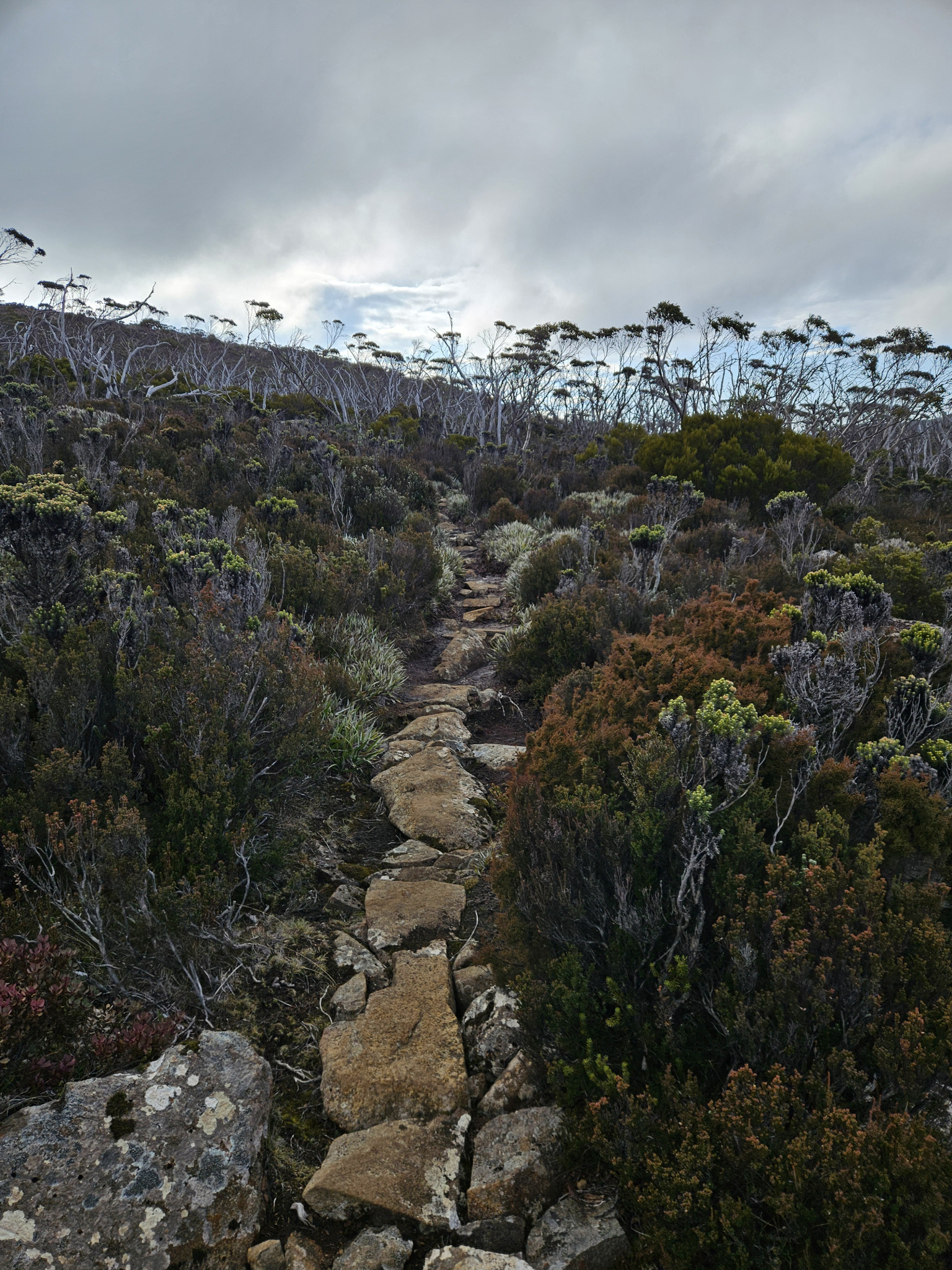
The trail to Thark Ridge begins on the other side of the road to the Big Bend Car Park. A few metres off the road, there is a sign directing you on to the trail. From this point, it is around 2.66km to Thark Ridge.
The trail leads off in a southwesterly direction, and for the most part is well marked with orange arrows, as you make your way through the stunted, sub-alpine flora. The trail is quite rocky, and you will come across several dolerite boulder fields that require some rock hopping.
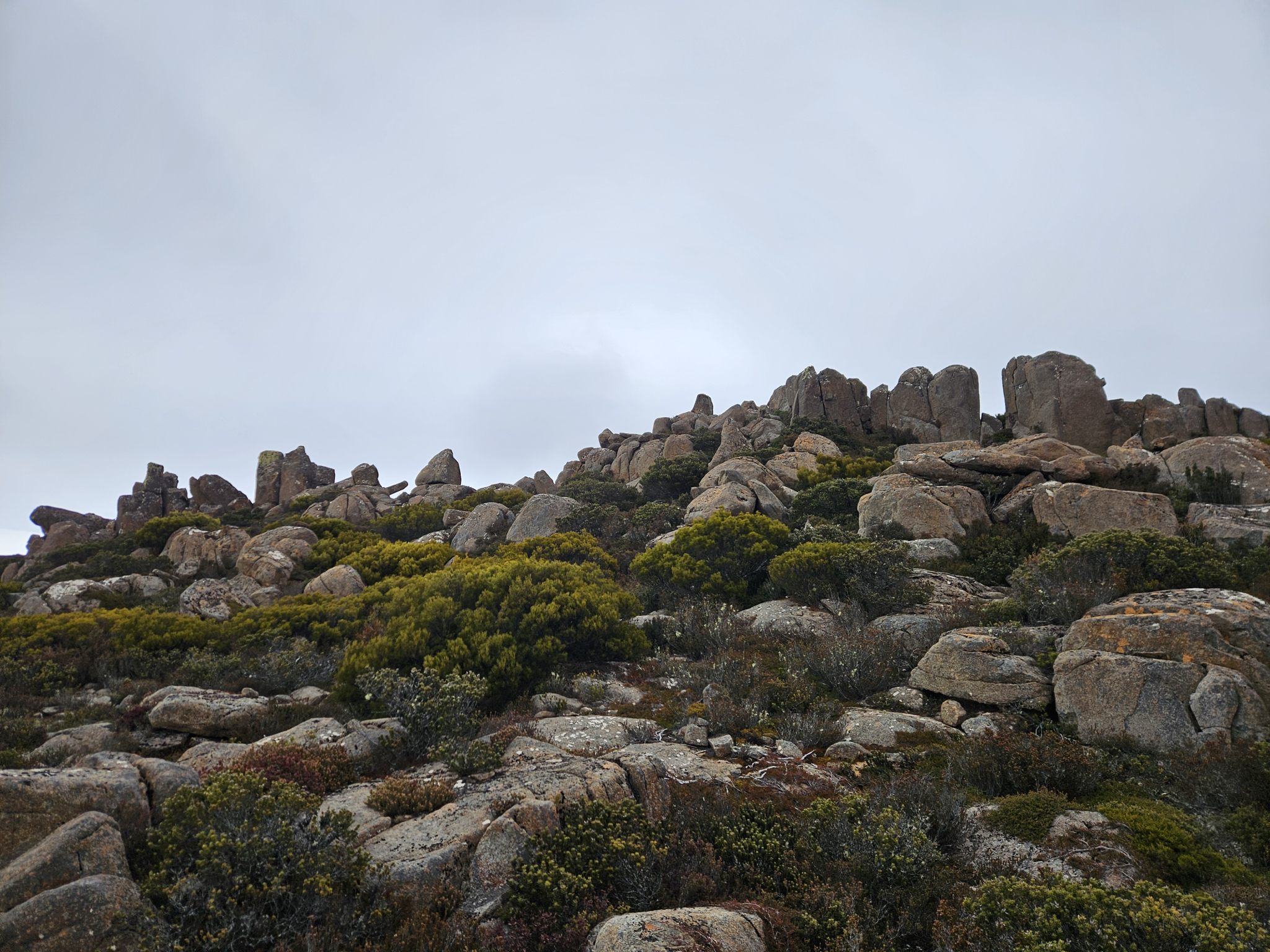
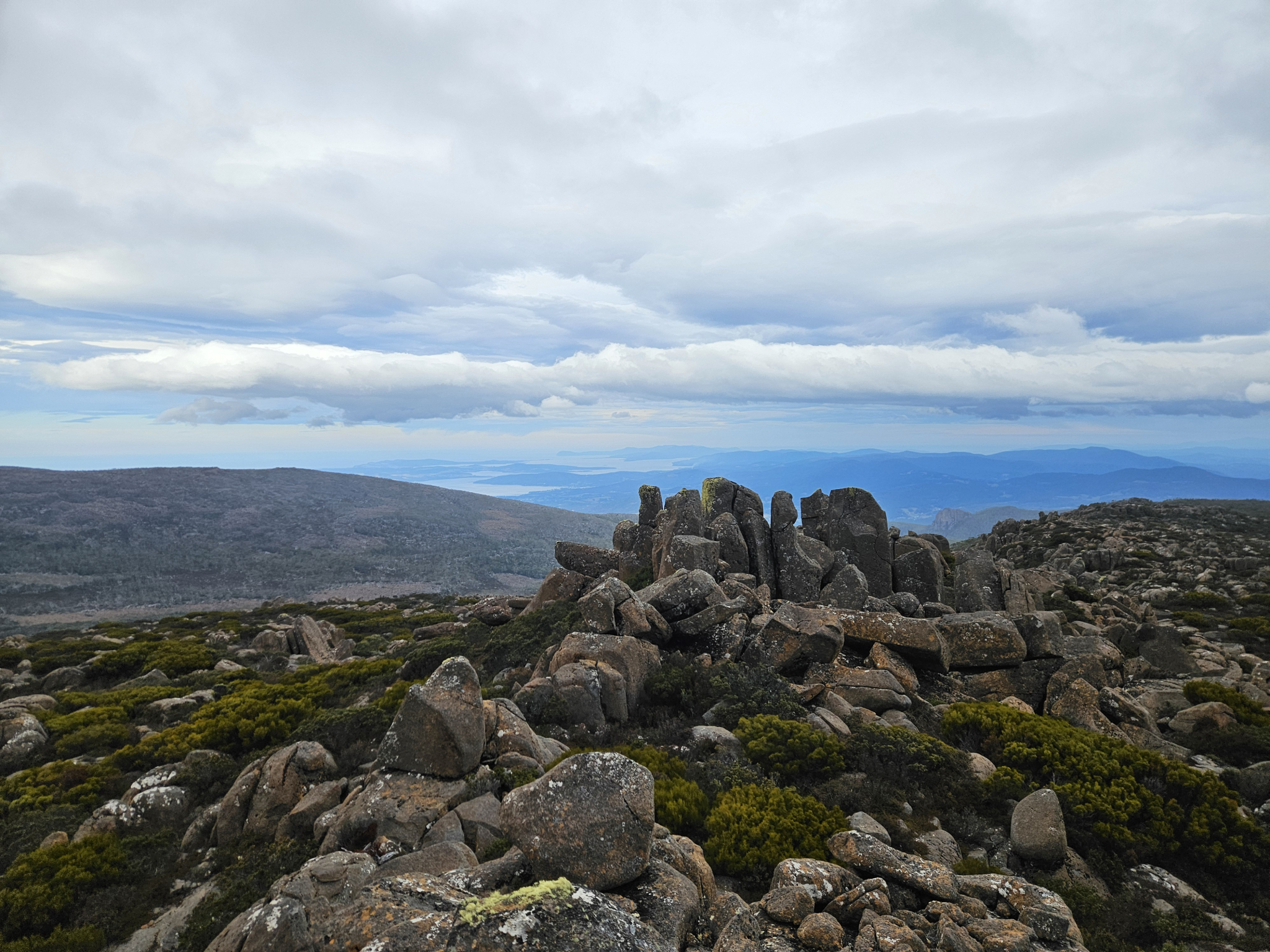
Towards the end of the trail, you will begin to head more consistently uphill, gaining around 50 metres in altitude. After this point, you will come to a track intersection with a signpost directing you to either the Thark Ridge Track or the Devils Throne Track. Continue along the Thark Ridge Track for around 180 metres. At this point, you will have a rocky outcrop off to your right in a southwesterly direction. This is Thark Ridge.
The final 100 metres to the top of the ridge is off-track, with a rough pad in some parts and the occasional rock cairn along the way. The terrain is mostly low-lying heath and shrubs, scattered with large dolerite boulders.
Ensure you take note of which direction you are travelling in, so that you can easily retrace your steps on the way down. Continue aiming for the highest point, and you will come to the top of Thark Ridge, where there are two, large, rocky outcrops.
From here, unless there is very low cloud, you will have excellent views in all directions. Looking northwest, you will see Collins Cap and the other peaks that make up the Wellington Range, while looking southwest will show you the Huon Valley, and southeast will show Kunanyi’s peak, with the D'entrecasteaux channel and Bruny Island slightly further south from there. If it is windy, there are plenty of large boulders to shelter behind while you have a snack or some lunch, before making your way back the way you came.
On the way down from the ridge, keep an eye out for the directional arrows of the track. As long as you head in an easterly direction, you will meet up with the track again, however, care should still be taken so as not to get lost, especially if there is low-lying cloud that may make navigation more difficult.
If you choose to continue walking further there are several other walks in the area that you can continue, including the Devils Throne Track from the intersection near Thark Ridge, Mount Montegu, which is further along the Thark Ridge Track, or further on to the Montagu Thumbs and Cathedral Rock.
If attempting any of the trails mentioned above, refer to the corresponding trail guide for more information and ensure you have enough time and are appropriately prepared.
Conditions
This walk is extremely exposed to the weather, with strong winds, freezing temperatures, snow and rain occurring regularly. The trail is often wet, which can be extremely slippery if frozen over, requiring additional care.
While conditions may be fine at the outset of your walk, weather conditions within in this section of the park can change rapidly, potentially bringing high winds, rain, fog, and snow, even during summer.
Check local weather forecasts before attempting any walks in Wellington Park. Also be aware that roads may be closed on certain days during winter due to icy roads and snow cover.
Ensure you have appropriate sun protection, as UV radiation is stronger in high altitude areas, such as on mountains. The fire danger rating for the area should also be checked. Be aware that Wellington Park is closed on days with a fire danger rating of Extreme or Catastrophic in the Upper Derwent Valley or South East districts.
For up to date weather forecasting on Kunanyi/Mount Wellington, refer to: http://www.bom.gov.au/tas/forecasts/mtwellington.shtml
Safety advice
This is an exposed walk at an altitude of around 1200 metres, with weather conditions changing rapidly in the area, and freezing temperatures occurring regularly. There is a short section of off-track walking shortly before the summit of the ridge, and it is easy to become lost if you aren’t paying attention to a map and your surroundings.
The trail is very rocky and often wet, and after cold weather wet sections may be frozen, making them very slippery, requiring additional caution.
Ensure you are appropriately prepared for mountain weather conditions, and have warm clothing, a waterproof jacket, sturdy walking boots, a map, compass, food and water. Attempting walks in this region without adequate preparation is extremely dangerous, and may lead to hypothermia and death.
There are sections of the trail where you may have limited access to mobile service, and hikers should let at least two people know which hike they are completing in case of an emergency.
Hikers should also be aware of the possibility of bushfires as this is a forested environment.
During spring, summer and autumn, be aware that snakes may be active in the area. If encountered, move away from them slowly.
If you are injured and require emergency medical attention, call 000.
For further information on bushfires in Tasmania, refer to: https://www.fire.tas.gov.au/
Age restrictions and advice
This walk is not appropriate for young children.
Location
Pinnacle Road, Wellington Park Tasmania 7054, Australia
From Hobart, drive up Davey Street, which later becomes Huon Road. Continue around 7.2km past the Southern Outlet intersection before turning on to Pillinger Drive, which then becomes Pinnacle Road. From the turnoff, continue up the road for 9.6km, where you will reach the Big Bend Carpark on your left.
Alternatively, the Kunanyi/Mt Wellington Explorer Bus can be used to Access the Big Bend Car Park as well as other parts of the mountain, with more information provided here: https://mtwellingtonexplorer.com.au/
Nature
Park size: 18,011 hectares
Natural features
Natural features along the way include Richea scoparia, Tasmanian Mountain Pepper (Tasmannia Lanceolata), Tasmanian snow gum (Eucalyptus coccifera), Alpine Yellow Gum (Eucalyptus subcrenulata) and large, lichen covered Dolerite boulder fields.
Conservation
Kunanyi/Mt Wellington is a known breeding ground for the critically endangered Swift Parrot (Lathamus discolor) and is also home to the endangered Tasmanian Masked Owl (Tyto novaehollandiae castanops), Wedge-tailed Eagle (Aquila audax fleayi) and Tasmanian Devil (Sarcophilus harrisii).
Feral cats are a threat to biodiversity within the park, as are other Introduced species including the Superb Lyrebird (Menura novaehollandiae).
Track details
The trail to Thark Ridge begins on the other side of the road to the Big Bend Car Park. A few metres off the road, there is a sign directing you on to the trail. From this point, it is around 2.66km to Thark Ridge.
The trail leads off in a southwesterly direction, and for the most part is well marked with orange arrows, as you make your way through the stunted, sub-alpine flora. The trail is quite rocky, and you will come across several dolerite boulder fields that require some rock hopping.
Towards the end of the trail, you will begin to head more consistently uphill, gaining around 50 metres in altitude. After this point, you will come to a track intersection with a signpost directing you to either the Thark Ridge Track or the Devils Throne Track. Continue along the Thark Ridge Track for around 180 metres. At this point, you will have a rocky outcrop off to your right in a southwesterly direction. This is Thark Ridge.
The final 100 metres to the top of the ridge is off-track, with a rough pad in some parts and the occasional rock cairn along the way. The terrain is mostly low-lying heath and shrubs, scattered with large dolerite boulders.
Ensure you take note of which direction you are travelling in, so that you can easily retrace your steps on the way down. Continue aiming for the highest point, and you will come to the top of Thark Ridge, where there are two, large, rocky outcrops.
From here, unless there is very low cloud, you will have excellent views in all directions. Looking northwest, you will see Collins Cap and the other peaks that make up the Wellington Range, while looking southwest will show you the Huon Valley, and southeast will show Kunanyi’s peak, with the D'entrecasteaux channel and Bruny Island slightly further south from there. If it is windy, there are plenty of large boulders to shelter behind while you have a snack or some lunch, before making your way back the way you came.
On the way down from the ridge, keep an eye out for the directional arrows of the track. As long as you head in an easterly direction, you will meet up with the track again, however, care should still be taken so as not to get lost, especially if there is low-lying cloud that may make navigation more difficult.
If you choose to continue walking further there are several other walks in the area that you can continue, including the Devils Throne Track from the intersection near Thark Ridge, Mount Montegu, which is further along the Thark Ridge Track, or further on to the Montagu Thumbs and Cathedral Rock.
If attempting any of the trails mentioned above, refer to the corresponding trail guide for more information and ensure you have enough time and are appropriately prepared.
Conditions
This walk is extremely exposed to the weather, with strong winds, freezing temperatures, snow and rain occurring regularly. The trail is often wet, which can be extremely slippery if frozen over, requiring additional care.
While conditions may be fine at the outset of your walk, weather conditions within in this section of the park can change rapidly, potentially bringing high winds, rain, fog, and snow, even during summer.
Check local weather forecasts before attempting any walks in Wellington Park. Also be aware that roads may be closed on certain days during winter due to icy roads and snow cover.
Ensure you have appropriate sun protection, as UV radiation is stronger in high altitude areas, such as on mountains. The fire danger rating for the area should also be checked. Be aware that Wellington Park is closed on days with a fire danger rating of Extreme or Catastrophic in the Upper Derwent Valley or South East districts.
For up to date weather forecasting on Kunanyi/Mount Wellington, refer to: http://www.bom.gov.au/tas/forecasts/mtwellington.shtml
Safety advice
This is an exposed walk at an altitude of around 1200 metres, with weather conditions changing rapidly in the area, and freezing temperatures occurring regularly. There is a short section of off-track walking shortly before the summit of the ridge, and it is easy to become lost if you aren’t paying attention to a map and your surroundings.
The trail is very rocky and often wet, and after cold weather wet sections may be frozen, making them very slippery, requiring additional caution.
Ensure you are appropriately prepared for mountain weather conditions, and have warm clothing, a waterproof jacket, sturdy walking boots, a map, compass, food and water. Attempting walks in this region without adequate preparation is extremely dangerous, and may lead to hypothermia and death.
There are sections of the trail where you may have limited access to mobile service, and hikers should let at least two people know which hike they are completing in case of an emergency.
Hikers should also be aware of the possibility of bushfires as this is a forested environment.
During spring, summer and autumn, be aware that snakes may be active in the area. If encountered, move away from them slowly.
If you are injured and require emergency medical attention, call 000.
For further information on bushfires in Tasmania, refer to: https://www.fire.tas.gov.au/
Age restrictions and advice
This walk is not appropriate for young children.
Location
Pinnacle Road, Wellington Park Tasmania 7054, Australia
From Hobart, drive up Davey Street, which later becomes Huon Road. Continue around 7.2km past the Southern Outlet intersection before turning on to Pillinger Drive, which then becomes Pinnacle Road. From the turnoff, continue up the road for 9.6km, where you will reach the Big Bend Carpark on your left.
Alternatively, the Kunanyi/Mt Wellington Explorer Bus can be used to Access the Big Bend Car Park as well as other parts of the mountain, with more information provided here: https://mtwellingtonexplorer.com.au/