
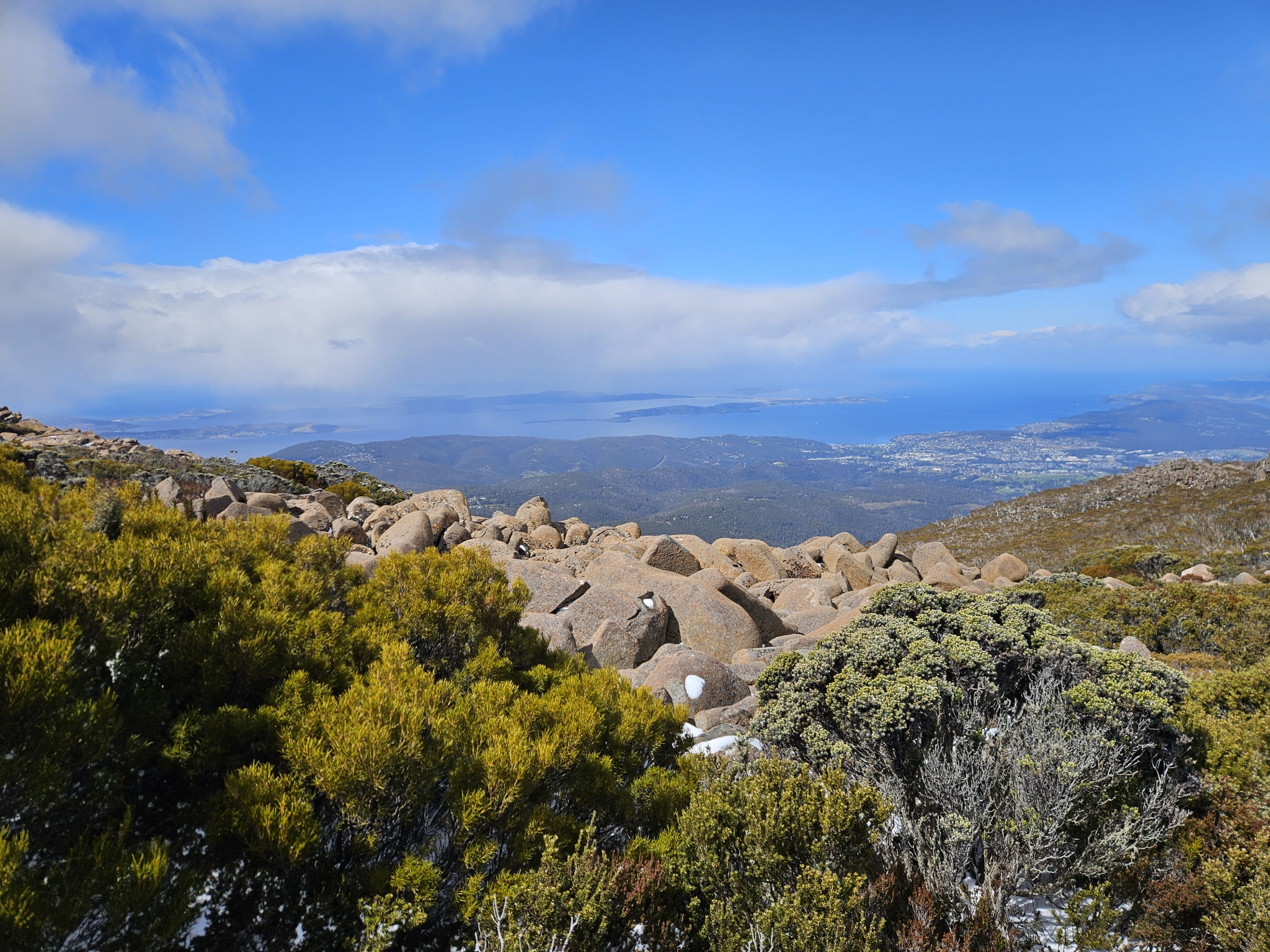
A stunning, lesser used trail that quickly immerses you in the alpine landscape of the wellington plateau, with excellent views, towering, dolerite boulders and alpine flora.
Highlights
Epic views over Hobart and the surrounding areas as well as over the plateau behind the pinnacle, towering dolerite boulders, ragged alpine terrain and flora.
Nature
Park size: 18,011 hectares
Natural features
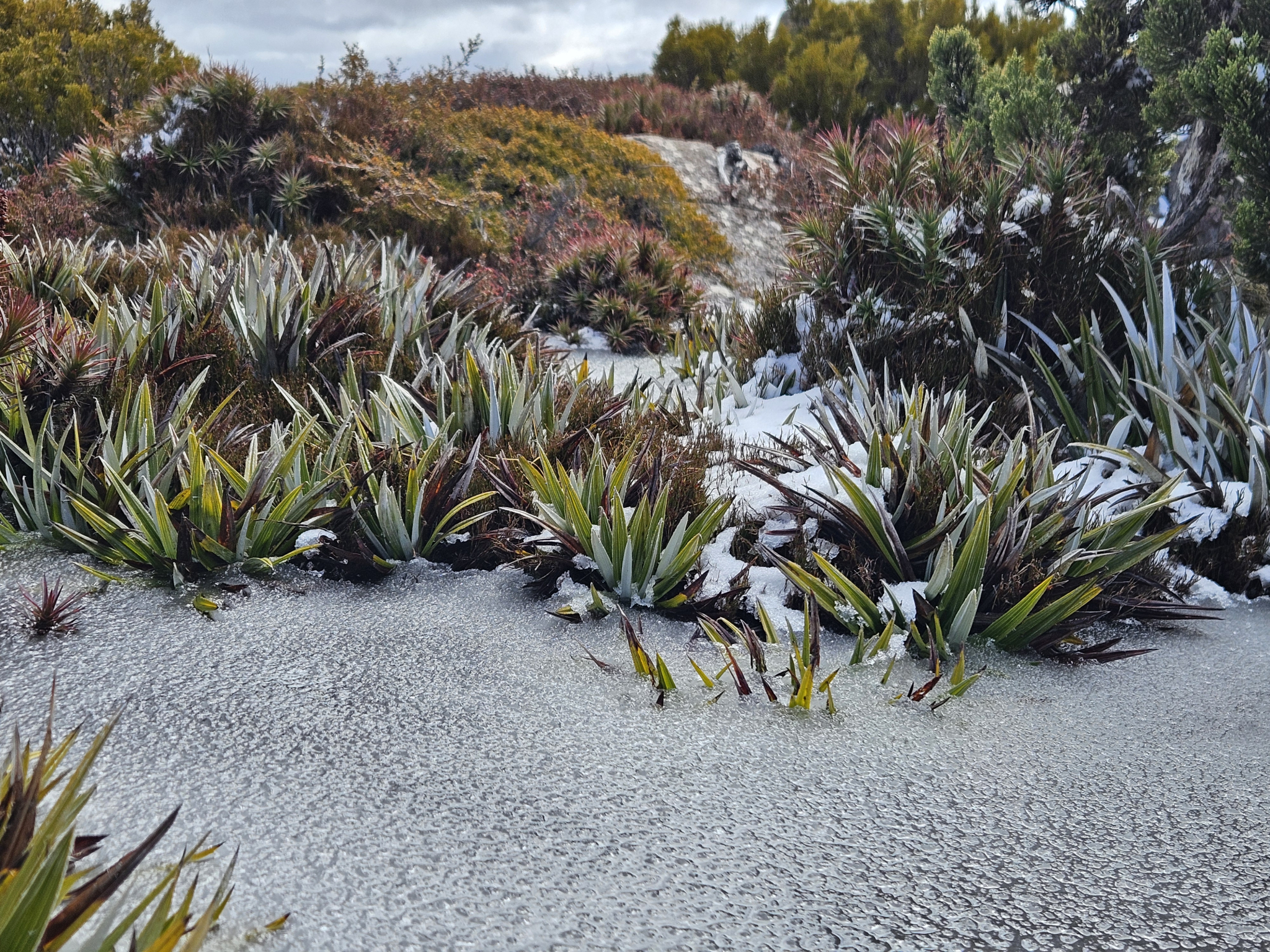
Extensive alpine shrubs and ground covers including Pineapple Grass (Astelia alpina) and Mountain Pepper Berry (Tasmannia lanceolata), periglacial dolerite rock formations, and frequent snow and ice.
Conservation
Kunanyi/Mt Wellington is a known breeding ground for the critically endangered Swift Parrot (Lathamus discolor) and is also home to the endangered Tasmanian Masked Owl (Tyto novaehollandiae castanops), Wedge-tailed Eagle (Aquila audax fleayi) and Tasmanian Devil (Sarcophilus harrisii).
Feral cats are a threat to biodiversity within the park, as are other Introduced species including the Superb Lyrebird (Menura novaehollandiae).
Track details
The trail begins at the far end of the pinnacle car park, close to the communications tower infrastructure. Walk around 200 metres down the trail, and you will come to an intersection. Take the right-hand path on to the South Wellington Track.
From this point, while the trail is still reasonably clear, it is not as well-graded as the trail you will have just left, and you should keep an eye out for orange arrow markers to ensure you are on the right track, especially after snow.
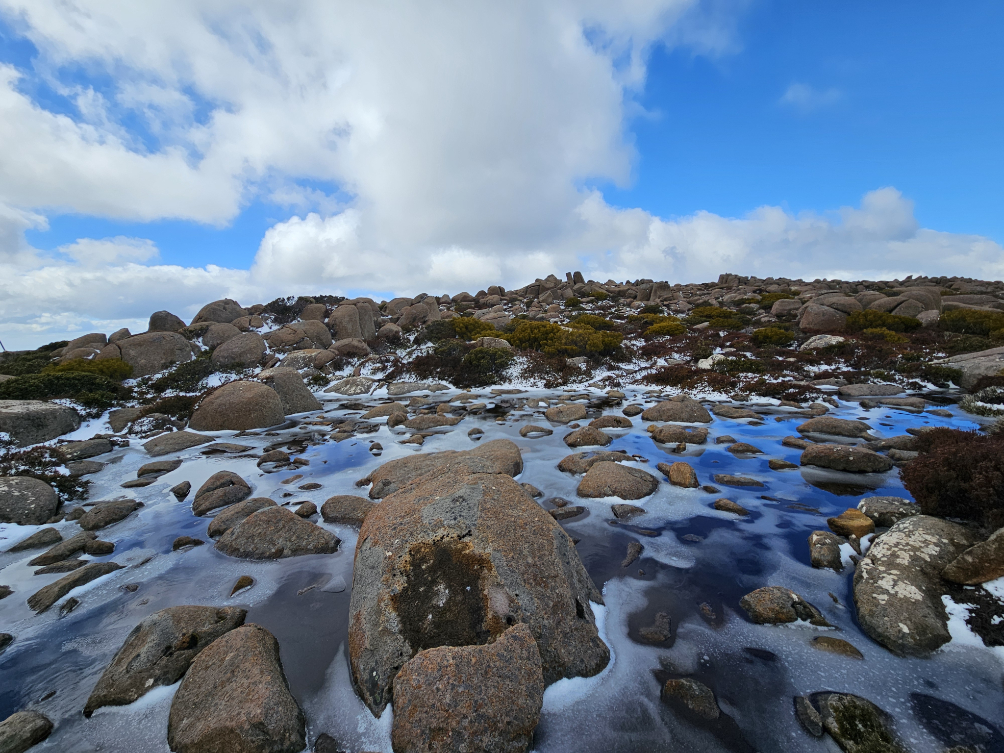
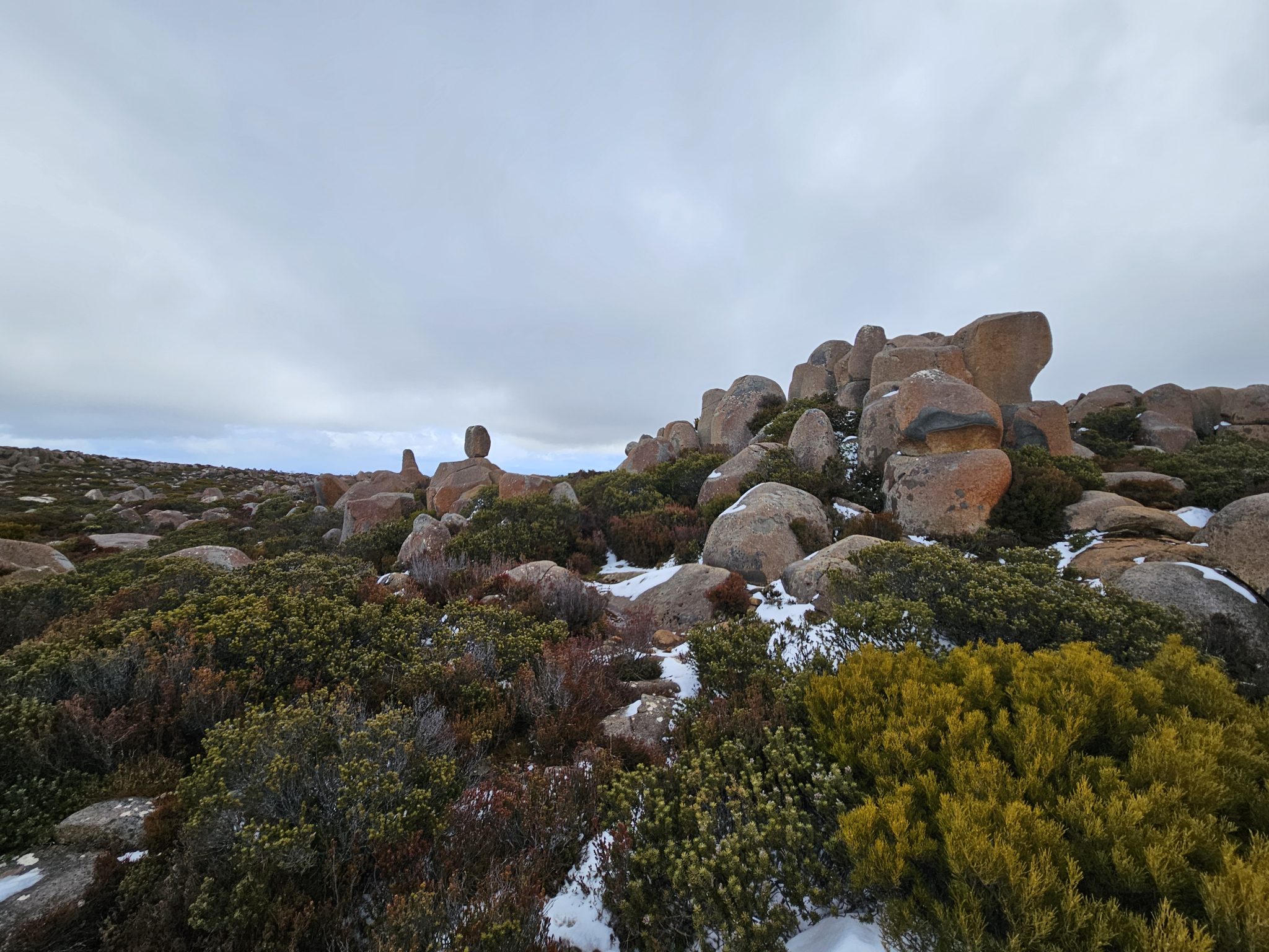
From this point, the trail continues for around 2.23km. As you make your way further along the trail, you will quickly leave the busy pinnacle carpark, becoming surrounded by alpine shrubs and towering, dolerite boulders.
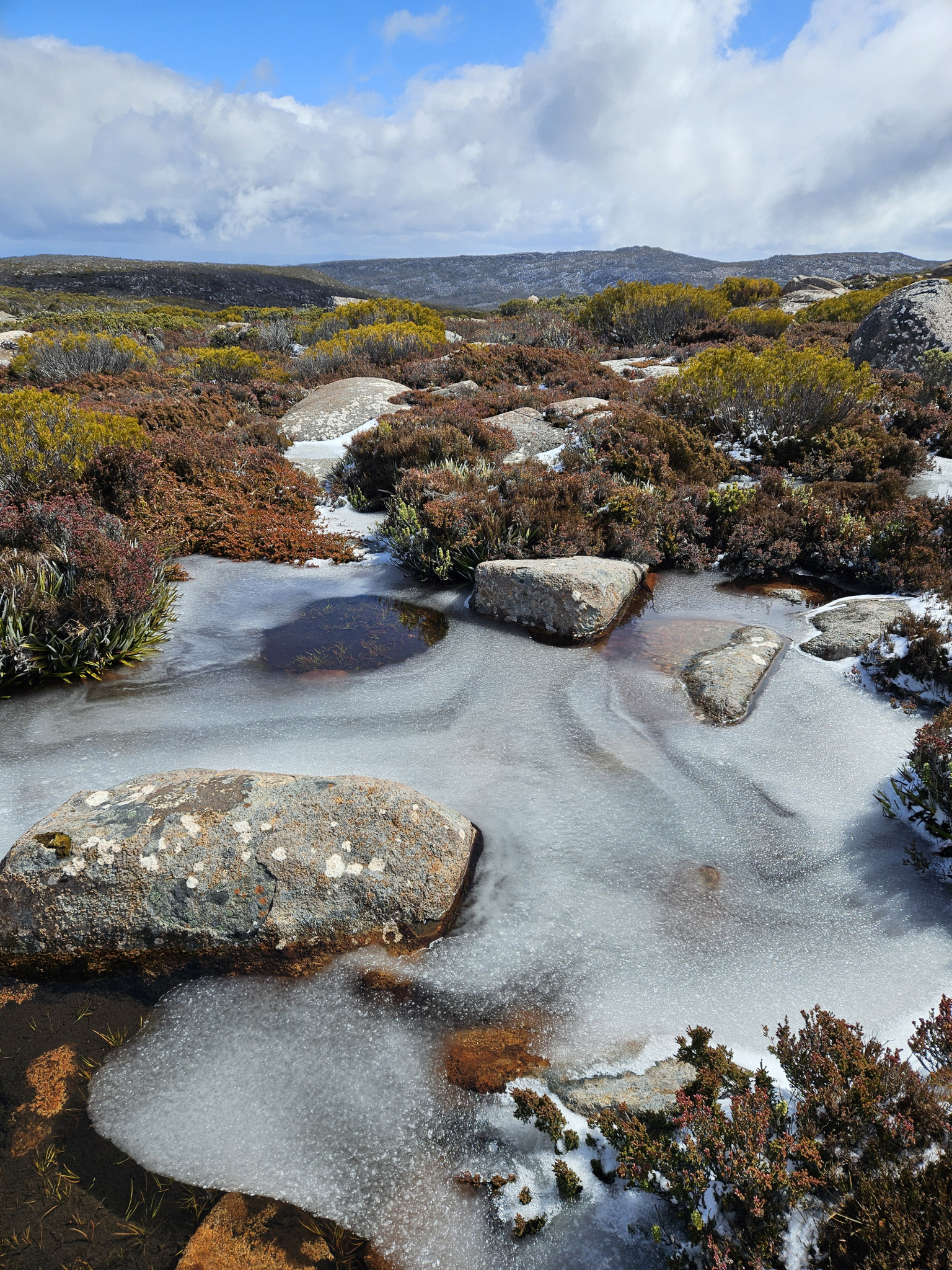
This part of the mountain is at the edge of the North West Bay River water catchment, with water gathering on the plateau before flowing into the river on the south side of the mountain. As such, the trail can often become wet and sometimes muddy, especially if there has been recent snow. It does, however, look especially beautiful during colder weather when the pools of water begin to freeze.
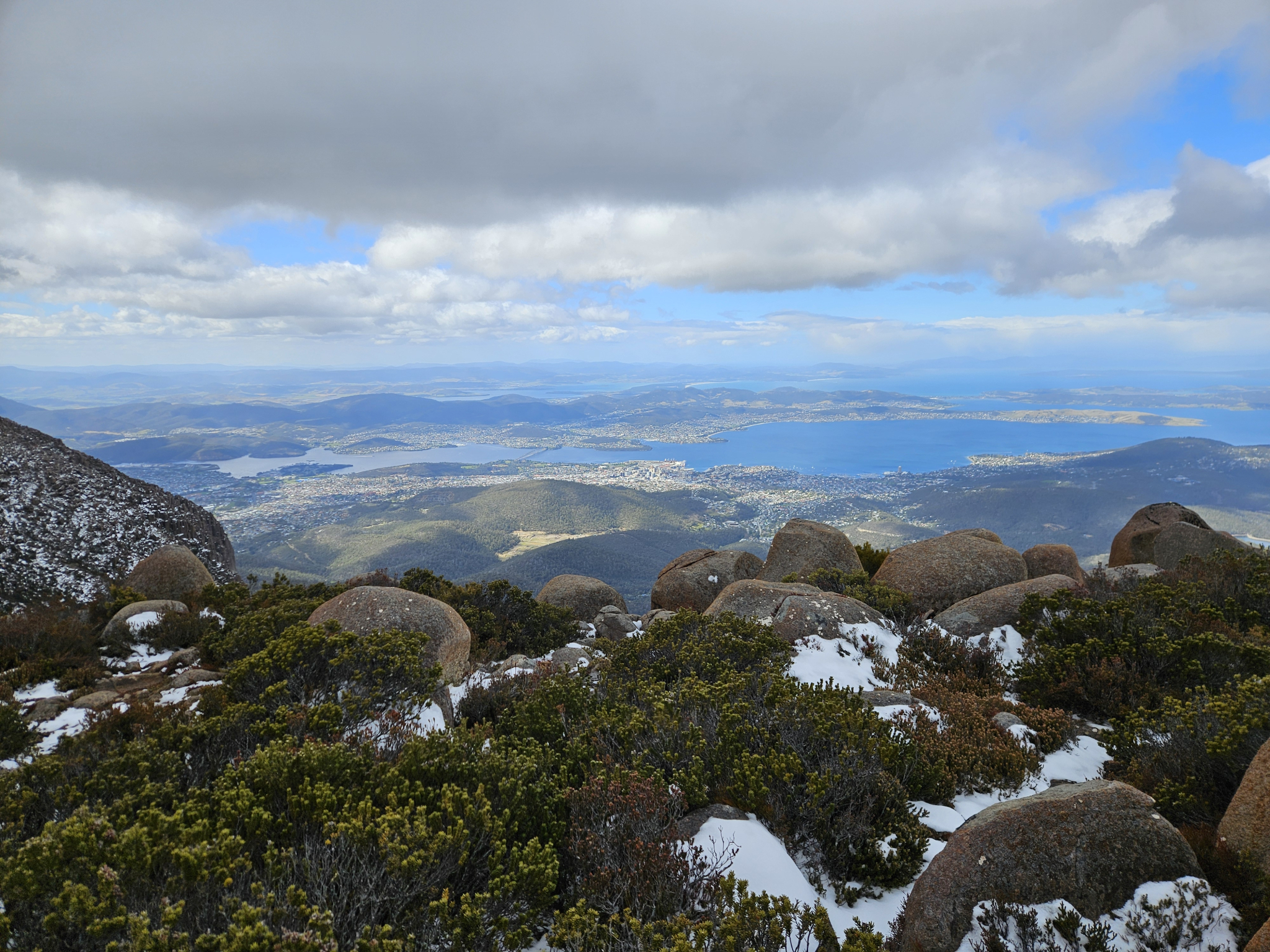
After walking around 1.9km, the trail will begin to head down the east side of the plateau, requiring some light rock scrambling. The view looking out away from the mountain takes in the southern end of the Derwent estuary and Storm Bay, as well as the surrounding areas.
After walking around 350 metres from this point, you will reach the end of the South Wellington Track. At this point, you will see several signposts with directions for Smiths Monument Track and The Ice House Track, as well as an interpretation sign about John Smith, a hiker who passed away in the area in 1858.
If you wish to extend your hike a short distance, you have the option of continuing to Smiths Monument, which is around 1.8km return. If you choose this option, please refer to the Smiths Monument track notes. There is also the option of walking down the Ice House Track, however, this is a difficult trail and will extend your walk into a full day walk.
Otherwise, begin returning back along the South Wellington Track, following the way you came.
Conditions
Weather conditions within Wellington Park can change rapidly, potentially bringing high winds, rain, and snow, even in summer. Check local weather forecasts before attempting any walks in Wellington Park. Also be aware that roads may be closed on certain days during winter due to icy roads and snow cover.
Ensure you have appropriate sun protection, as UV radiation is stronger in high altitude areas, such as on mountains. The fire danger rating for the area should also be checked. Be aware that Wellington Park is closed on days with a fire danger rating of Extreme or Catastrophic in the Upper Derwent Valley or South East districts.
For up to date weather forecasting on Kunanyi/Mount Wellington, refer to: http://www.bom.gov.au/tas/forecasts/mtwellington.shtml
Safety advice
This trail is extremely exposed to the elements and should not be attempted during storms, blizzards or other adverse weather events. While generally easy to follow, after heavy snow the trail may not be visible, in which case walkers should follow the arrow markers. If these are not visible, the walk should not be attempted.
Ensure you are appropriately prepared for mountain weather conditions, and have warm clothing, a waterproof jacket, sturdy walking boots, and food and water.
Weather conditions can change rapidly within the area, with freezing temperatures occurring regularly.
Hikers should also be aware of the possibility of bushfires as this is a forested environment.
During spring, summer and autumn, be aware that snakes may be active in the area. If encountered, move away from them slowly.
If you are injured and require emergency medical attention, call 000.
For further information on bushfires in Tasmania, refer to: https://www.fire.tas.gov.au/
Age restrictions and advice
This walk is suitable for all ages, however, adult supervision of children is recommended.
Location
200 Pinnacle Road, Wellington Park Tasmania 7054, Australia
From Hobart, drive up Davey Street, which later becomes Huon Road. Continue around 7.2km past the Southern Outlet intersection before turning on to Pillinger Drive, which then becomes Pinnacle Road. From the turnoff, continue up the road for 11km to the pinnacle carpark at the top of Kunanyi/Mt Wellington. Here, you will find multiple car parks, however, it can be busy during holidays and weekends. The track begins at the far, southern end of the carpark.
Nature
Park size: 18,011 hectares
Natural features
Extensive alpine shrubs and ground covers including Pineapple Grass (Astelia alpina) and Mountain Pepper Berry (Tasmannia lanceolata), periglacial dolerite rock formations, and frequent snow and ice.
Conservation
Kunanyi/Mt Wellington is a known breeding ground for the critically endangered Swift Parrot (Lathamus discolor) and is also home to the endangered Tasmanian Masked Owl (Tyto novaehollandiae castanops), Wedge-tailed Eagle (Aquila audax fleayi) and Tasmanian Devil (Sarcophilus harrisii).
Feral cats are a threat to biodiversity within the park, as are other Introduced species including the Superb Lyrebird (Menura novaehollandiae).
Track details
The trail begins at the far end of the pinnacle car park, close to the communications tower infrastructure. Walk around 200 metres down the trail, and you will come to an intersection. Take the right-hand path on to the South Wellington Track.
From this point, while the trail is still reasonably clear, it is not as well-graded as the trail you will have just left, and you should keep an eye out for orange arrow markers to ensure you are on the right track, especially after snow.
From this point, the trail continues for around 2.23km. As you make your way further along the trail, you will quickly leave the busy pinnacle carpark, becoming surrounded by alpine shrubs and towering, dolerite boulders.
This part of the mountain is at the edge of the North West Bay River water catchment, with water gathering on the plateau before flowing into the river on the south side of the mountain. As such, the trail can often become wet and sometimes muddy, especially if there has been recent snow. It does, however, look especially beautiful during colder weather when the pools of water begin to freeze.
After walking around 1.9km, the trail will begin to head down the east side of the plateau, requiring some light rock scrambling. The view looking out away from the mountain takes in the southern end of the Derwent estuary and Storm Bay, as well as the surrounding areas.
After walking around 350 metres from this point, you will reach the end of the South Wellington Track. At this point, you will see several signposts with directions for Smiths Monument Track and The Ice House Track, as well as an interpretation sign about John Smith, a hiker who passed away in the area in 1858.
If you wish to extend your hike a short distance, you have the option of continuing to Smiths Monument, which is around 1.8km return. If you choose this option, please refer to the Smiths Monument track notes. There is also the option of walking down the Ice House Track, however, this is a difficult trail and will extend your walk into a full day walk.
Otherwise, begin returning back along the South Wellington Track, following the way you came.
Conditions
Weather conditions within Wellington Park can change rapidly, potentially bringing high winds, rain, and snow, even in summer. Check local weather forecasts before attempting any walks in Wellington Park. Also be aware that roads may be closed on certain days during winter due to icy roads and snow cover.
Ensure you have appropriate sun protection, as UV radiation is stronger in high altitude areas, such as on mountains. The fire danger rating for the area should also be checked. Be aware that Wellington Park is closed on days with a fire danger rating of Extreme or Catastrophic in the Upper Derwent Valley or South East districts.
For up to date weather forecasting on Kunanyi/Mount Wellington, refer to: http://www.bom.gov.au/tas/forecasts/mtwellington.shtml
Safety advice
This trail is extremely exposed to the elements and should not be attempted during storms, blizzards or other adverse weather events. While generally easy to follow, after heavy snow the trail may not be visible, in which case walkers should follow the arrow markers. If these are not visible, the walk should not be attempted.
Ensure you are appropriately prepared for mountain weather conditions, and have warm clothing, a waterproof jacket, sturdy walking boots, and food and water.
Weather conditions can change rapidly within the area, with freezing temperatures occurring regularly.
Hikers should also be aware of the possibility of bushfires as this is a forested environment.
During spring, summer and autumn, be aware that snakes may be active in the area. If encountered, move away from them slowly.
If you are injured and require emergency medical attention, call 000.
For further information on bushfires in Tasmania, refer to: https://www.fire.tas.gov.au/
Age restrictions and advice
This walk is suitable for all ages, however, adult supervision of children is recommended.
Location
200 Pinnacle Road, Wellington Park Tasmania 7054, Australia
From Hobart, drive up Davey Street, which later becomes Huon Road. Continue around 7.2km past the Southern Outlet intersection before turning on to Pillinger Drive, which then becomes Pinnacle Road. From the turnoff, continue up the road for 11km to the pinnacle carpark at the top of Kunanyi/Mt Wellington. Here, you will find multiple car parks, however, it can be busy during holidays and weekends. The track begins at the far, southern end of the carpark.
Key info
1 hour 15 minutes return
5.2km return
Grade 3: Difficult
Facilities
There are public toilets located at the start of this trail at the
pinnacle, as well as a lookout shelter, however there are no facilities further along the walk. Pets are not permitted on this track.