
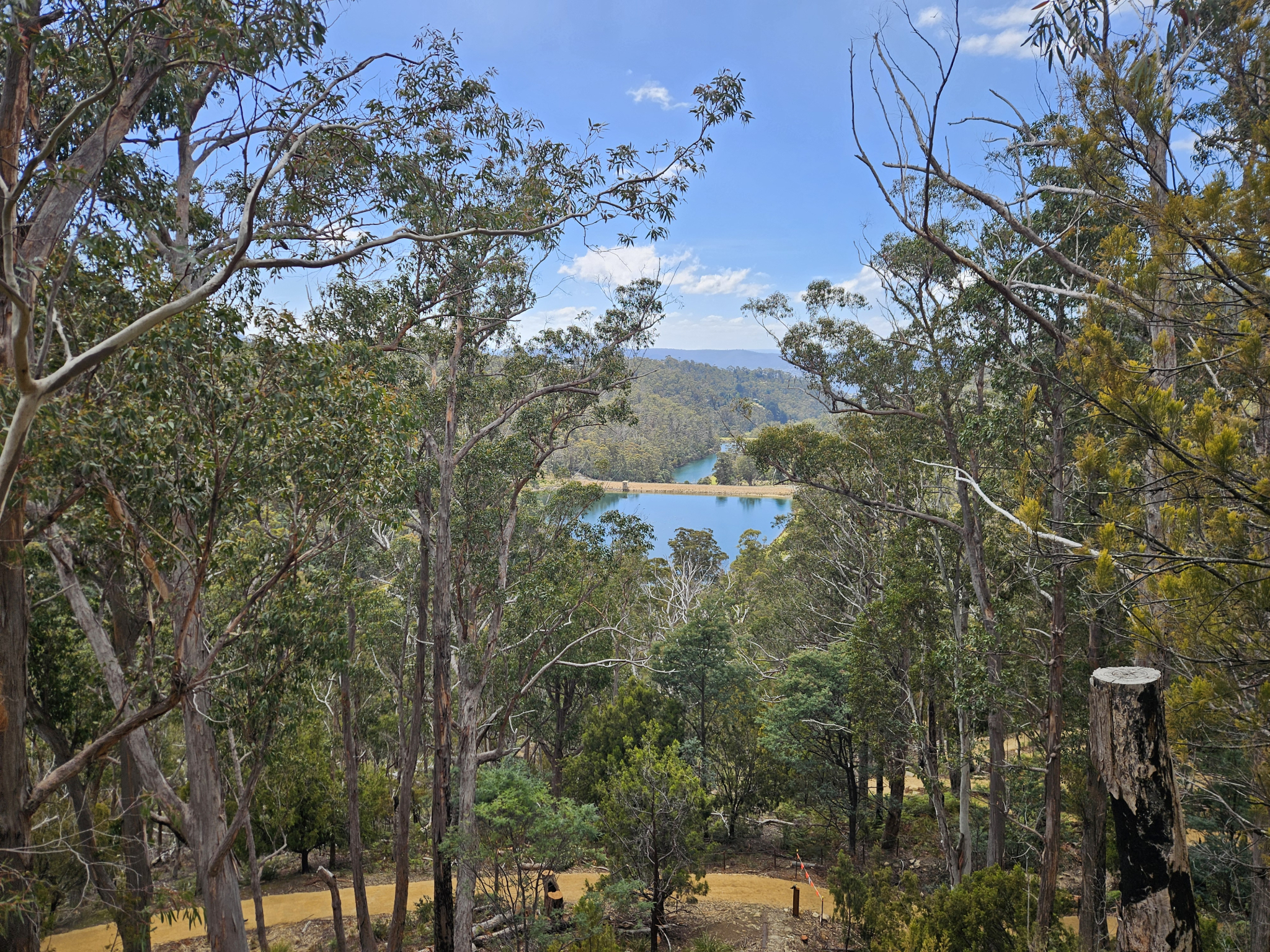
A short walk through the forest at Waterworks Reserve to a historic sandstone outcrop where a channel has been cut by hand to allow water to funnel into Hobarts water catchment. Despite the name, water no longer flows here, however, there is an excellent view through the forest and over the Waterworks reservoir.
Highlights
Excellent views from the top of the sandstone outcrop, historic feats of engineering, and plentiful local wildlife, with pademelons and wallabies making regular appearances, as well as the varied birdlife of Waterworks Reserve.
Nature
Park size: 32 hectares
Natural features
Marsupials such as Pademelons and the Bennetts Wallaby are regularly spotted, as are varying birdlife including white-bellied sea eagle, wedge-tailed eagles, fantails, ravens, kookaburras, yellow-tailed black cockatoos, native hens and much more. The walk runs through dry sclerophyll forest, with yellow wattle blossoms being prominent during spring, and other prominent species including Tasmanian native cherry (Exocarpos cupressiformis).
Conservation
Waterworks Reserve at the foot of Kunanyi/Mount Wellington and the surrounding forests are a known breeding ground for the critically endangered Swift Parrot (Lathamus discolor) and is also home to the endangered Tasmanian Masked Owl (Tyto novaehollandiae castanops), Wedge-tailed Eagle (Aquila audax fleayi) and Tasmanian Devil (Sarcophilus harrisii).
Feral cats are a threat to biodiversity within the park, as are other Introduced species including the Superb Lyrebird (Menura novaehollandiae).
Track details
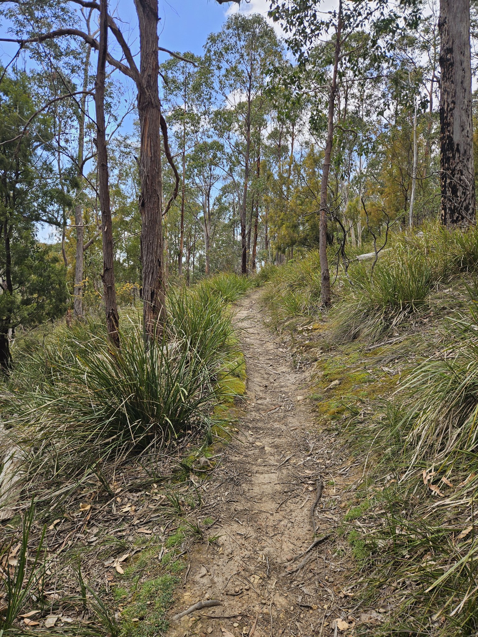
The trail to Gentle Annie Falls starts at the end of the narrow road that runs through Waterworks Reserve. Follow the signpost straight ahead. You will begin by following the Sandy Bay Rivulet for the first few hundred metres, crossing a small bridge along the way. You will then begin to make your way up the winding trail up the hill, with the forest quickly drying out once away from the rivulet.
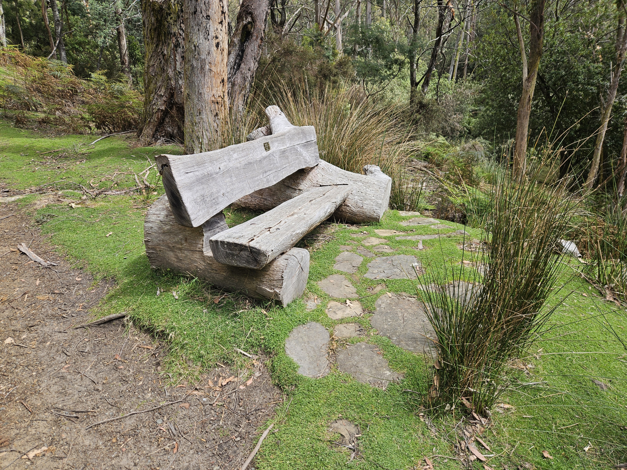
Around 300m into the walk, you will pass a chair and an intersection. Continue on the track you are on, heading further up the hill. After walking for some time and after passing a second bench where you can take a rest if needed, you will come to a track intersection. To get to Gentle Annie Falls, take the left-hand turn, walking down a short section of the Pipeline track.
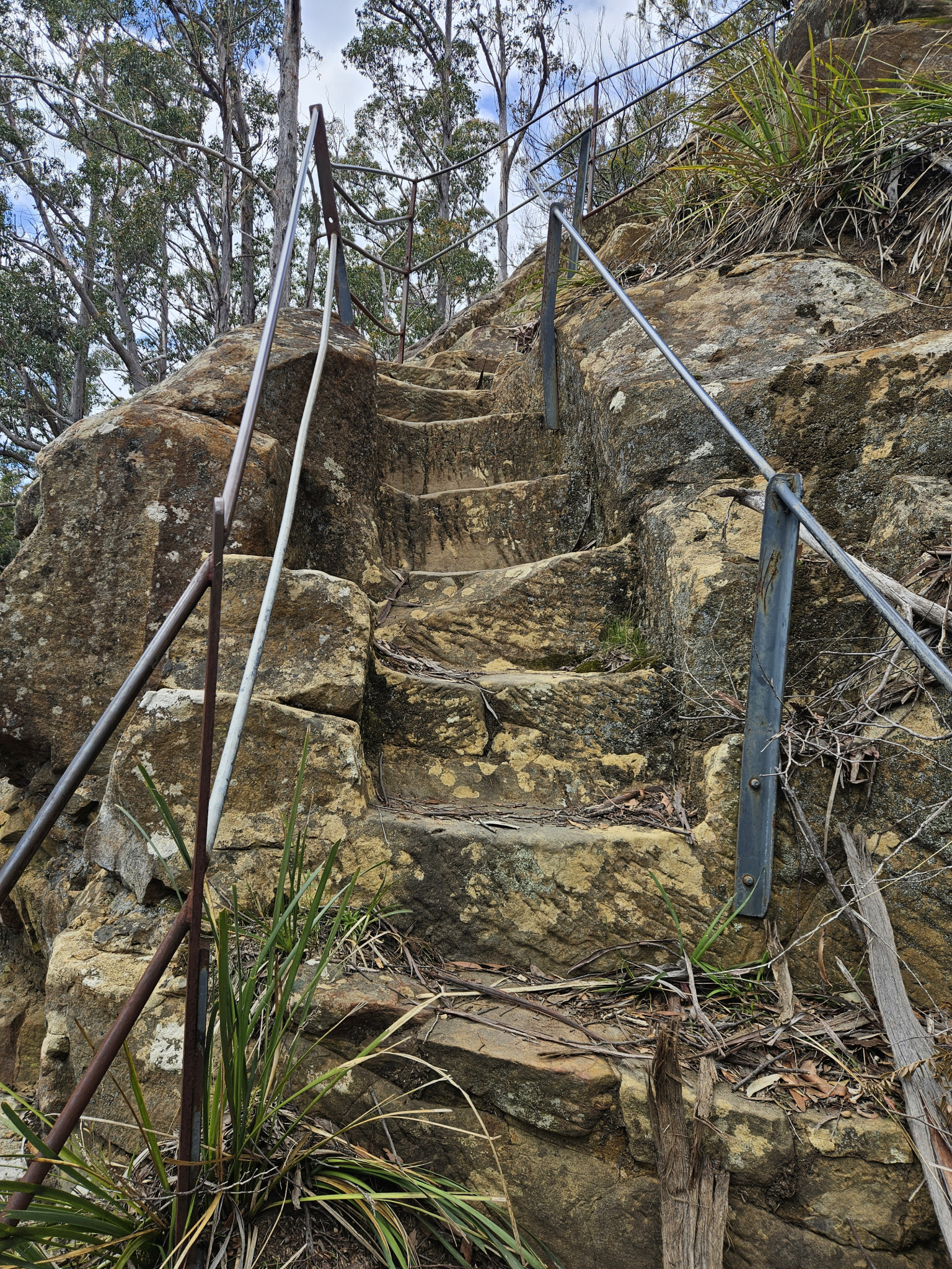
After walking around 50 metres, you will come to a rough track that heads up the hill to your right. You will pass the sandstone chute where the bottom section of Gentle Annie Falls once was, which, until 1940, fed water into a pipeline for Hobart's water supply. After making your way up the steep sandstone stairs, you will be rewarded with lovely views over waterworks and the surrounding forest.
From here, you can continue exploring the area, heading further up the hill to a similar rocky outcrop where there was once a second waterfall.
If you wish to continue walking further, you can continue up the track to join onto the Pipeline Track. Otherwise, when you are ready, make your way back the way you came.
History
Place history
Originally the site of a waterfall which was then built over with the sandstone chute that is now in place during the second half of the 19th century by the Hobart Town Corporation to channel water down to the towns water reservoirs below. It has been dry since being redirected in 1940 to flow into a higher reservoir at Ridgeway.
Conditions
Weather conditions can change rapidly, potentially bringing high winds and rain, even in summer. Check local weather forecasts before attempting any walks in the area.
Ensure you have appropriate sun protection. The fire danger rating for the area should also be checked. Be aware that Waterworks Reserve may be closed on days with a fire danger rating of Extreme or Catastrophic in the Upper Derwent Valley or Southeast districts.
For up-to-date weather forecasting on Waterworks Reserve, refer to: https://www.bom.gov.au/places/tas/south-hobart/
Safety advice
Do not attempt to swim in the reservoirs, as it is the source of Hobart’s drinking water and swimming is prohibited.
The final section of track up to the lookout is steep and extra care should be taken, especially with young children. In addition, while the lookout is has a basic fence, It can easily be climbed over or walked around, and as such, children should be accompanied at all times.
Ensure you are appropriately prepared for the conditions, and have weather-appropriate clothing, a waterproof jacket, walking shoes or boots, water, and snacks.
Be aware that weather conditions can change rapidly within the area.
Hikers should also be aware of the possibility of bushfires as this is a forested environment.
During spring, summer and autumn, be aware that snakes may be active in the area. If encountered, move away from them slowly.
If you are injured and require emergency medical attention, call 000.
For further information on bushfires in Tasmania, refer to: https://www.fire.tas.gov.au/
Age restrictions and advice
The final section of this walk is very steep, and as such, while this walk is appropriate for all ages, very young children may require assistance on the final section.
Location
7054, Tasmania, Australia
From central Hobart, drive up Davey Street (B64) for about 2.4km, until you come to Romilly Street. Turn left onto Romilly St and continue for 500 meters, where you will meet Waterworks Road and turn right. From here, follow Waterworks Road for 1km, then take a right hand turn through the gates into Waterworks Reserve. Continue driving slowly along the road for around 800 metres. You will come to the end of the road where there is a small car park. Park here, or, if there aren’t any parks left, back track a short distance and use one of the other car parking areas throughout Waterworks Reserve and then make your way back to the end of the road.
Nature
Park size: 32 hectares
Natural features
Marsupials such as Pademelons and the Bennetts Wallaby are regularly spotted, as are varying birdlife including white-bellied sea eagle, wedge-tailed eagles, fantails, ravens, kookaburras, yellow-tailed black cockatoos, native hens and much more. The walk runs through dry sclerophyll forest, with yellow wattle blossoms being prominent during spring, and other prominent species including Tasmanian native cherry (Exocarpos cupressiformis).
Conservation
Waterworks Reserve at the foot of Kunanyi/Mount Wellington and the surrounding forests are a known breeding ground for the critically endangered Swift Parrot (Lathamus discolor) and is also home to the endangered Tasmanian Masked Owl (Tyto novaehollandiae castanops), Wedge-tailed Eagle (Aquila audax fleayi) and Tasmanian Devil (Sarcophilus harrisii).
Feral cats are a threat to biodiversity within the park, as are other Introduced species including the Superb Lyrebird (Menura novaehollandiae).
Track details
The trail to Gentle Annie Falls starts at the end of the narrow road that runs through Waterworks Reserve. Follow the signpost straight ahead. You will begin by following the Sandy Bay Rivulet for the first few hundred metres, crossing a small bridge along the way. You will then begin to make your way up the winding trail up the hill, with the forest quickly drying out once away from the rivulet.
Around 300m into the walk, you will pass a chair and an intersection. Continue on the track you are on, heading further up the hill. After walking for some time and after passing a second bench where you can take a rest if needed, you will come to a track intersection. To get to Gentle Annie Falls, take the left-hand turn, walking down a short section of the Pipeline track.
After walking around 50 metres, you will come to a rough track that heads up the hill to your right. You will pass the sandstone chute where the bottom section of Gentle Annie Falls once was, which, until 1940, fed water into a pipeline for Hobart's water supply. After making your way up the steep sandstone stairs, you will be rewarded with lovely views over waterworks and the surrounding forest.
From here, you can continue exploring the area, heading further up the hill to a similar rocky outcrop where there was once a second waterfall.
If you wish to continue walking further, you can continue up the track to join onto the Pipeline Track. Otherwise, when you are ready, make your way back the way you came.
History
Place history
Originally the site of a waterfall which was then built over with the sandstone chute that is now in place during the second half of the 19th century by the Hobart Town Corporation to channel water down to the towns water reservoirs below. It has been dry since being redirected in 1940 to flow into a higher reservoir at Ridgeway.
Conditions
Weather conditions can change rapidly, potentially bringing high winds and rain, even in summer. Check local weather forecasts before attempting any walks in the area.
Ensure you have appropriate sun protection. The fire danger rating for the area should also be checked. Be aware that Waterworks Reserve may be closed on days with a fire danger rating of Extreme or Catastrophic in the Upper Derwent Valley or Southeast districts.
For up-to-date weather forecasting on Waterworks Reserve, refer to: https://www.bom.gov.au/places/tas/south-hobart/
Safety advice
Do not attempt to swim in the reservoirs, as it is the source of Hobart’s drinking water and swimming is prohibited.
The final section of track up to the lookout is steep and extra care should be taken, especially with young children. In addition, while the lookout is has a basic fence, It can easily be climbed over or walked around, and as such, children should be accompanied at all times.
Ensure you are appropriately prepared for the conditions, and have weather-appropriate clothing, a waterproof jacket, walking shoes or boots, water, and snacks.
Be aware that weather conditions can change rapidly within the area.
Hikers should also be aware of the possibility of bushfires as this is a forested environment.
During spring, summer and autumn, be aware that snakes may be active in the area. If encountered, move away from them slowly.
If you are injured and require emergency medical attention, call 000.
For further information on bushfires in Tasmania, refer to: https://www.fire.tas.gov.au/
Age restrictions and advice
The final section of this walk is very steep, and as such, while this walk is appropriate for all ages, very young children may require assistance on the final section.
Location
7054, Tasmania, Australia
From central Hobart, drive up Davey Street (B64) for about 2.4km, until you come to Romilly Street. Turn left onto Romilly St and continue for 500 meters, where you will meet Waterworks Road and turn right. From here, follow Waterworks Road for 1km, then take a right hand turn through the gates into Waterworks Reserve. Continue driving slowly along the road for around 800 metres. You will come to the end of the road where there is a small car park. Park here, or, if there aren’t any parks left, back track a short distance and use one of the other car parking areas throughout Waterworks Reserve and then make your way back to the end of the road.
Key info
35 minutes return
2km return
Grade 2: Moderate
Facilities
There are public toilets, bbq’s and picnic tables at the beginning of this walk, however, there are no facilities further along the trail.