
A lovely walk through the fern glade that leads into eucalyptus forest as you make your way up to a sandstone outcrop that was a bushrangers' hideout, Rocky Whelan’s Cave.
Highlights
Ferns, moss, and during autumn and winter, fungi, and a sandstone cave where the bushranger John “Rocky” Whelan was based whilst on the run in the 1850s.
Nature
Park size: 18,011 hectares
Natural features
Keep an eye and ear out for Yellow-tailed Black Cockatoos (Zanda funereal) and other birds as you make your way through the ferns and eucalyptus forest to the sandstone outcrop at Rocky Whelan's.
Conservation
Kunanyi/Mt Wellington is a known breeding ground for the critically endangered Swift Parrot (Lathamus discolor) and is also home to the endangered Tasmanian Masked Owl (Tyto novaehollandiae castanops), Wedge-tailed Eagle (Aquila audax fleayi) and Tasmanian Devil (Sarcophilus harrisii).
Feral cats are a threat to biodiversity within the park, as are other Introduced species including the Superb Lyrebird (Menura novaehollandiae).
Track details
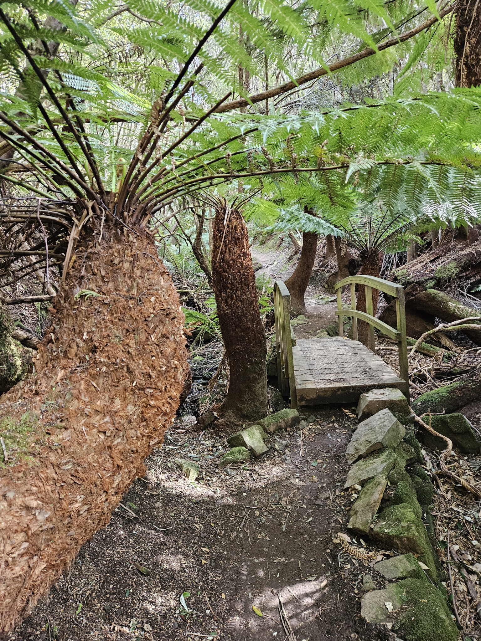
After parking at the Fern Glade Car Park, make your way up the steps into the forest. A short distance after the beginning of the trail you will pass a couple of intersections, however, continue heading straight ahead on your current trail, following the signposts towards The Springs. As you make your way steadily up, the track follows a creek bed which is often dry but may be flowing after heavy rain and snow.
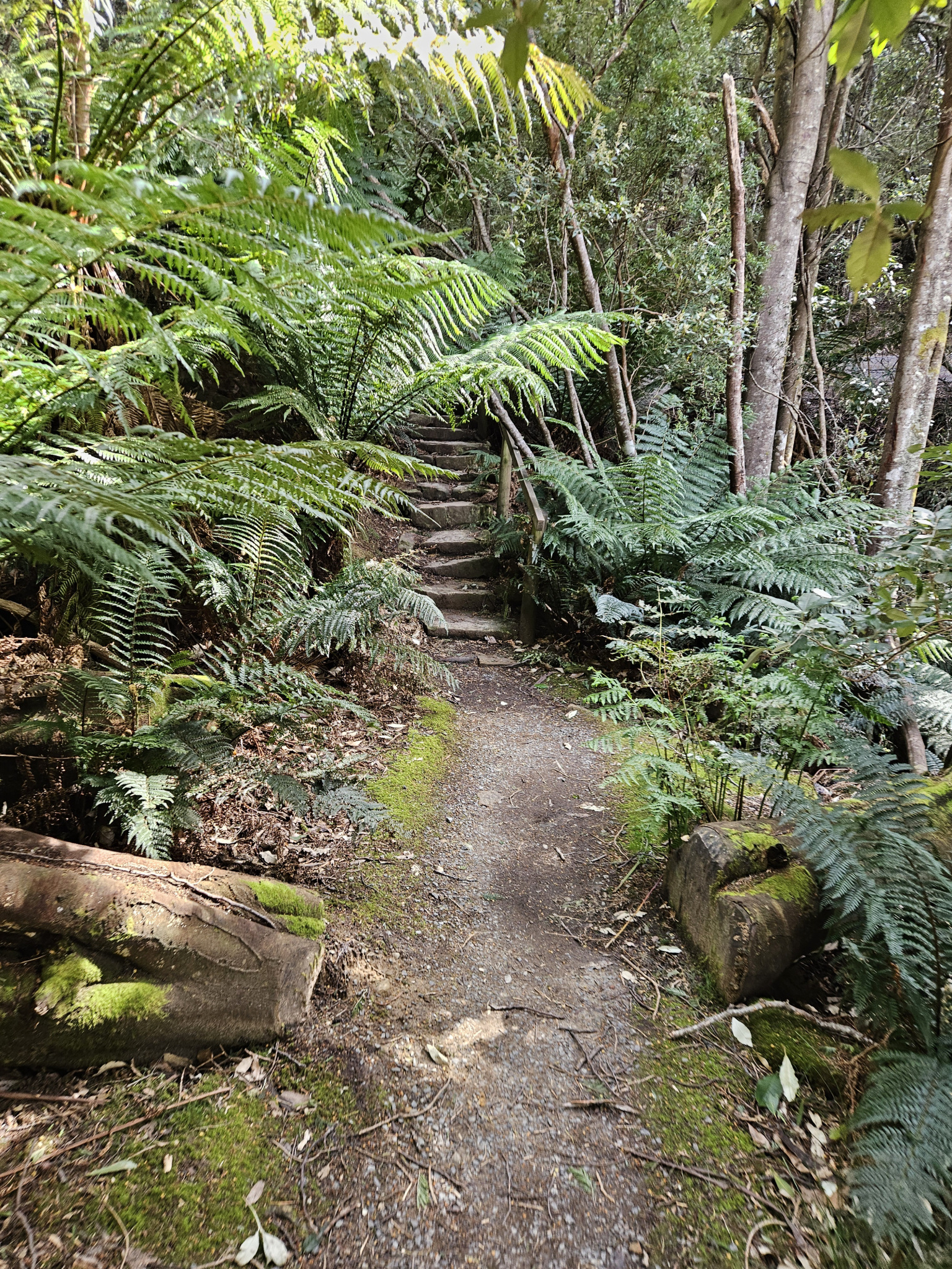
The forest around you is a mixture of wet forest and sclerophyl species, with plenty of ferns and moss. After walking around 570m, you will make your way up some stairs and cross the resevoir trail, to where the Fern glade track continues.
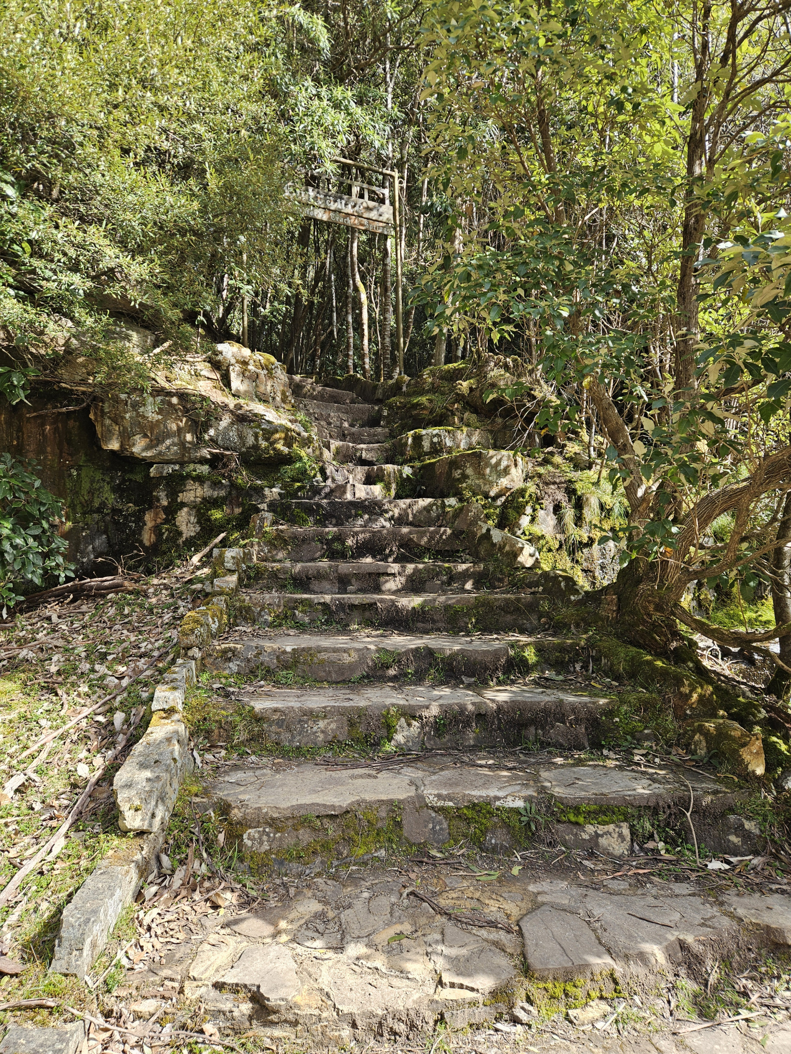
The trail continues to wind its way up the hill on a well-made track, with regular stone steps. By this stage you will no longer be following the creek. After walking around 1km, you will reach the Radford track intersection. To continue on to the end of the Fern Glade track and to Rocky Whelan's cave, continue straight ahead. From here, the Fern Glade track becomes mixed use, so keep an eye out for cyclists. After this point the track becomes wider and more level, and the forest type soon changes to dry eucalyptus forest.
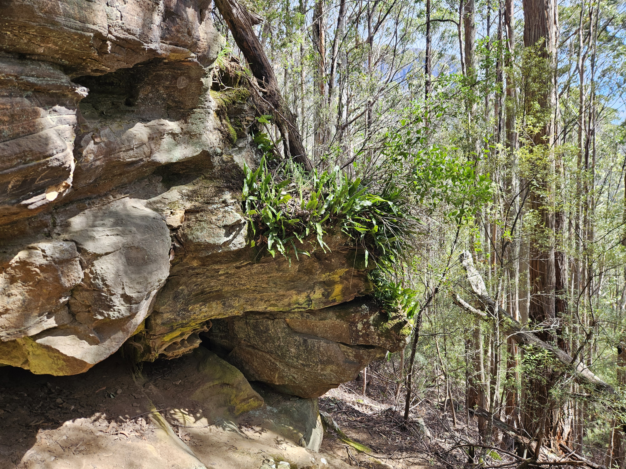
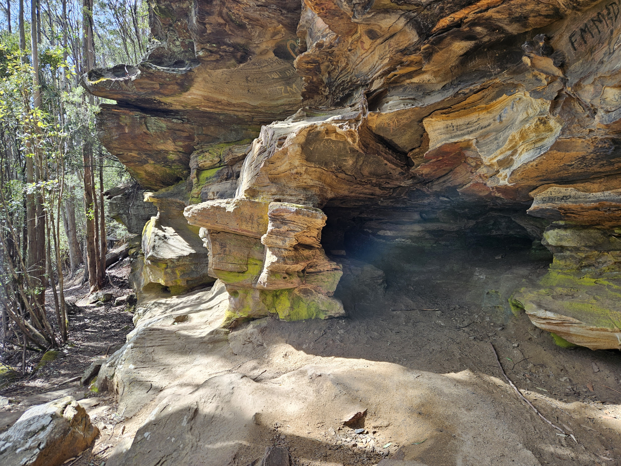
1.33km into the walk, you'll cross the Fingerpost Track. Continue straight ahead, and soon, you will come to the turnoff to Rocky Whelan's Cave. Take the left-hand turn and head up the trail a short distance, and you will come to a sandstone outcrop with an overhang and a small cave. This was the hideout of the bushranger John “Rocky” Whelan whilst he was on the run between 1854-55 after he had escaped from Port Arthur.
While the trees obscure the view of Hobart, if you head to the far side of the outcrop, the trail continues up to the top of the cliff, and you can see the mountain through the eucalyptus trees. From here, return the way you came, or continue on to one of the other trails in the area.
History
Name history
Rocky Whelan's Cave is named after the notorious bushranger, John "Rocky" Whelan, who is believed to have used it as a hideout for several months whilst on the run after escaping from Port Arthur.
Whelan was known to be an especially dangerous bushranger, known for shooting and robbing his victims. He was apprehended and hung for armed robbery in 1855, however, after his arrest he also confessed to the murder of several others.
Conditions
Weather conditions within Wellington Park can change rapidly, potentially bringing high winds, rain, and snow, even in summer. Check local weather forecasts before attempting any walks in Wellington Park.
Ensure you have appropriate sun protection, as UV radiation is stronger in high altitude areas, such as on mountains. The fire danger rating for the area should also be checked. Be aware that Wellington Park is closed on days with a fire danger rating of Extreme or Catastrophic in the Upper Derwent Valley or Southeast districts.
For up to date weather forecasting on Kunanyi/Mount Wellington, refer to: http://www.bom.gov.au/tas/forecasts/mtwellington.shtml
Safety advice
Ensure you are appropriately prepared for mountain weather conditions, and have warm clothing, a waterproof jacket, sturdy walking shoes or boots, water, and snacks.
Weather conditions can change rapidly within the area, with very cold temperatures occurring regularly.
Ensure you are paying attention to which trail you are taking, as there are many trails in the area, and it is easy to become disoriented and lost.
Hikers should also be aware of the possibility of bushfires as this is a forested environment.
During spring, summer and autumn, be aware that snakes may be active in the area. If encountered, move away from them slowly.
If you are injured and require emergency medical attention, call 000.
For further information on bushfires in Tasmania, refer to: https://www.fire.tas.gov.au/
Age restrictions and advice
While this walk is appropriate for all ages, there are some quite steep sections where very young children may require assistance.
Location
725 Huon Road, Wellington Park Tasmania 7054, Australia
From Hobart, drive up Davey Street, which later becomes Huon Road. Continue around 7.3km past the Southern Outlet intersection, and you will come to a small car park on your right. This is the Fern Glade Car Park and where this track begins.
If this car park is full, continue another few hundred metres to Fern Tree, and there is a larger car park outside the Fern Tree Tavern.
Nature
Park size: 18,011 hectares
Natural features
Keep an eye and ear out for Yellow-tailed Black Cockatoos (Zanda funereal) and other birds as you make your way through the ferns and eucalyptus forest to the sandstone outcrop at Rocky Whelan's.
Conservation
Kunanyi/Mt Wellington is a known breeding ground for the critically endangered Swift Parrot (Lathamus discolor) and is also home to the endangered Tasmanian Masked Owl (Tyto novaehollandiae castanops), Wedge-tailed Eagle (Aquila audax fleayi) and Tasmanian Devil (Sarcophilus harrisii).
Feral cats are a threat to biodiversity within the park, as are other Introduced species including the Superb Lyrebird (Menura novaehollandiae).
Track details
After parking at the Fern Glade Car Park, make your way up the steps into the forest. A short distance after the beginning of the trail you will pass a couple of intersections, however, continue heading straight ahead on your current trail, following the signposts towards The Springs. As you make your way steadily up, the track follows a creek bed which is often dry but may be flowing after heavy rain and snow.
The forest around you is a mixture of wet forest and sclerophyl species, with plenty of ferns and moss. After walking around 570m, you will make your way up some stairs and cross the resevoir trail, to where the Fern glade track continues.
The trail continues to wind its way up the hill on a well-made track, with regular stone steps. By this stage you will no longer be following the creek. After walking around 1km, you will reach the Radford track intersection. To continue on to the end of the Fern Glade track and to Rocky Whelan's cave, continue straight ahead. From here, the Fern Glade track becomes mixed use, so keep an eye out for cyclists. After this point the track becomes wider and more level, and the forest type soon changes to dry eucalyptus forest.
1.33km into the walk, you'll cross the Fingerpost Track. Continue straight ahead, and soon, you will come to the turnoff to Rocky Whelan's Cave. Take the left-hand turn and head up the trail a short distance, and you will come to a sandstone outcrop with an overhang and a small cave. This was the hideout of the bushranger John “Rocky” Whelan whilst he was on the run between 1854-55 after he had escaped from Port Arthur.
While the trees obscure the view of Hobart, if you head to the far side of the outcrop, the trail continues up to the top of the cliff, and you can see the mountain through the eucalyptus trees. From here, return the way you came, or continue on to one of the other trails in the area.
History
Name history
Rocky Whelan's Cave is named after the notorious bushranger, John "Rocky" Whelan, who is believed to have used it as a hideout for several months whilst on the run after escaping from Port Arthur.
Whelan was known to be an especially dangerous bushranger, known for shooting and robbing his victims. He was apprehended and hung for armed robbery in 1855, however, after his arrest he also confessed to the murder of several others.
Conditions
Weather conditions within Wellington Park can change rapidly, potentially bringing high winds, rain, and snow, even in summer. Check local weather forecasts before attempting any walks in Wellington Park.
Ensure you have appropriate sun protection, as UV radiation is stronger in high altitude areas, such as on mountains. The fire danger rating for the area should also be checked. Be aware that Wellington Park is closed on days with a fire danger rating of Extreme or Catastrophic in the Upper Derwent Valley or Southeast districts.
For up to date weather forecasting on Kunanyi/Mount Wellington, refer to: http://www.bom.gov.au/tas/forecasts/mtwellington.shtml
Safety advice
Ensure you are appropriately prepared for mountain weather conditions, and have warm clothing, a waterproof jacket, sturdy walking shoes or boots, water, and snacks.
Weather conditions can change rapidly within the area, with very cold temperatures occurring regularly.
Ensure you are paying attention to which trail you are taking, as there are many trails in the area, and it is easy to become disoriented and lost.
Hikers should also be aware of the possibility of bushfires as this is a forested environment.
During spring, summer and autumn, be aware that snakes may be active in the area. If encountered, move away from them slowly.
If you are injured and require emergency medical attention, call 000.
For further information on bushfires in Tasmania, refer to: https://www.fire.tas.gov.au/
Age restrictions and advice
While this walk is appropriate for all ages, there are some quite steep sections where very young children may require assistance.
Location
725 Huon Road, Wellington Park Tasmania 7054, Australia
From Hobart, drive up Davey Street, which later becomes Huon Road. Continue around 7.3km past the Southern Outlet intersection, and you will come to a small car park on your right. This is the Fern Glade Car Park and where this track begins.
If this car park is full, continue another few hundred metres to Fern Tree, and there is a larger car park outside the Fern Tree Tavern.
Key info
50 return
3km return
Grade 2: Moderate
There are no facilities on this walk, however, in Fern Tree there are public toilets and a tavern where lunch and dinner can be purchased which is a few hundred metres further around the corner along the road from the trailhead.