
A walk on the lesser visited North-east side of the Wellington Range, this trail is a solid uphill trek through rain forest and sub-alpine flora. You’ll pass a beautiful waterfall on the way, and on a clear day, be rewarded with excellent views from the summit of Collins Cap.
Highlights
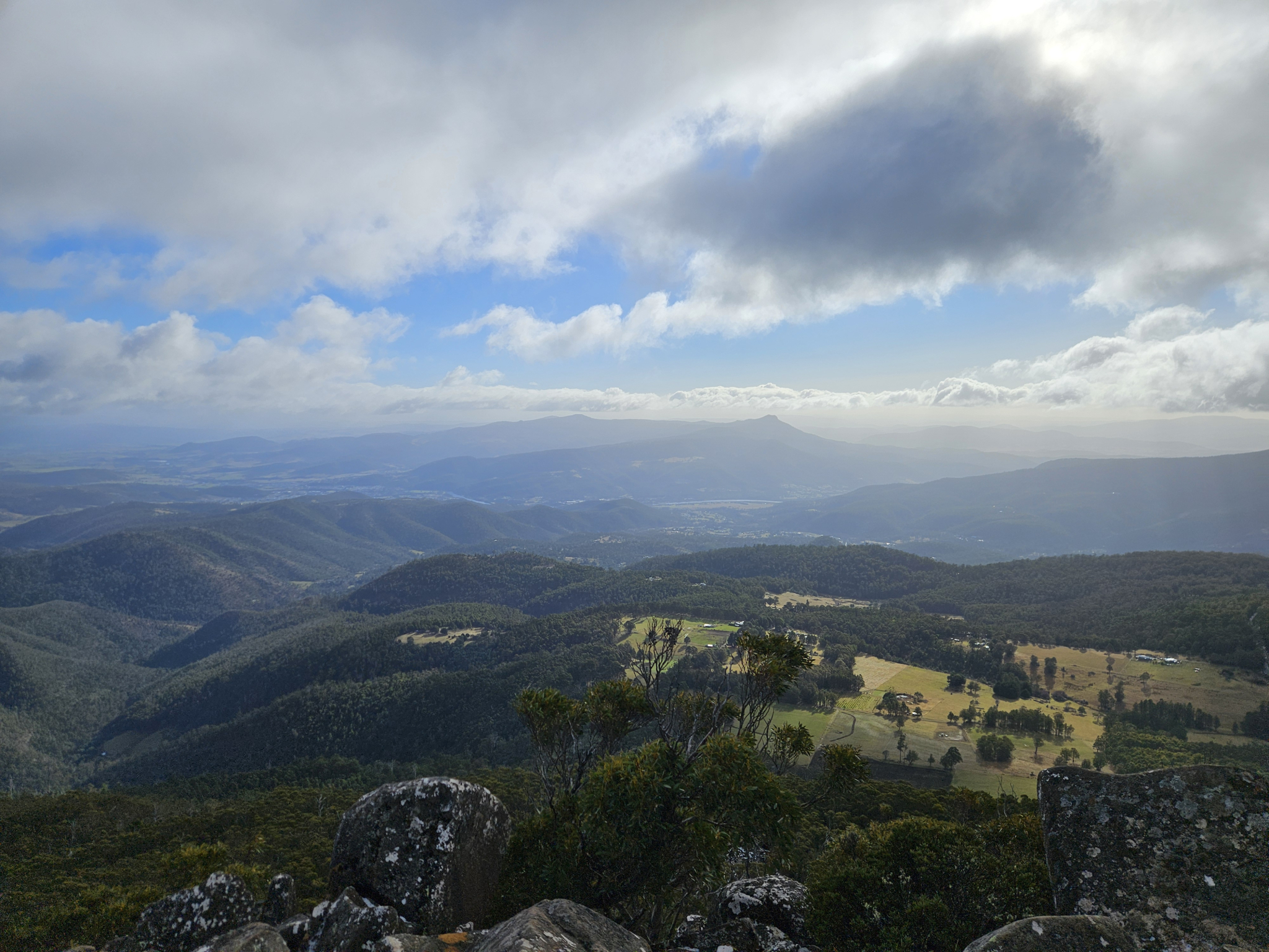
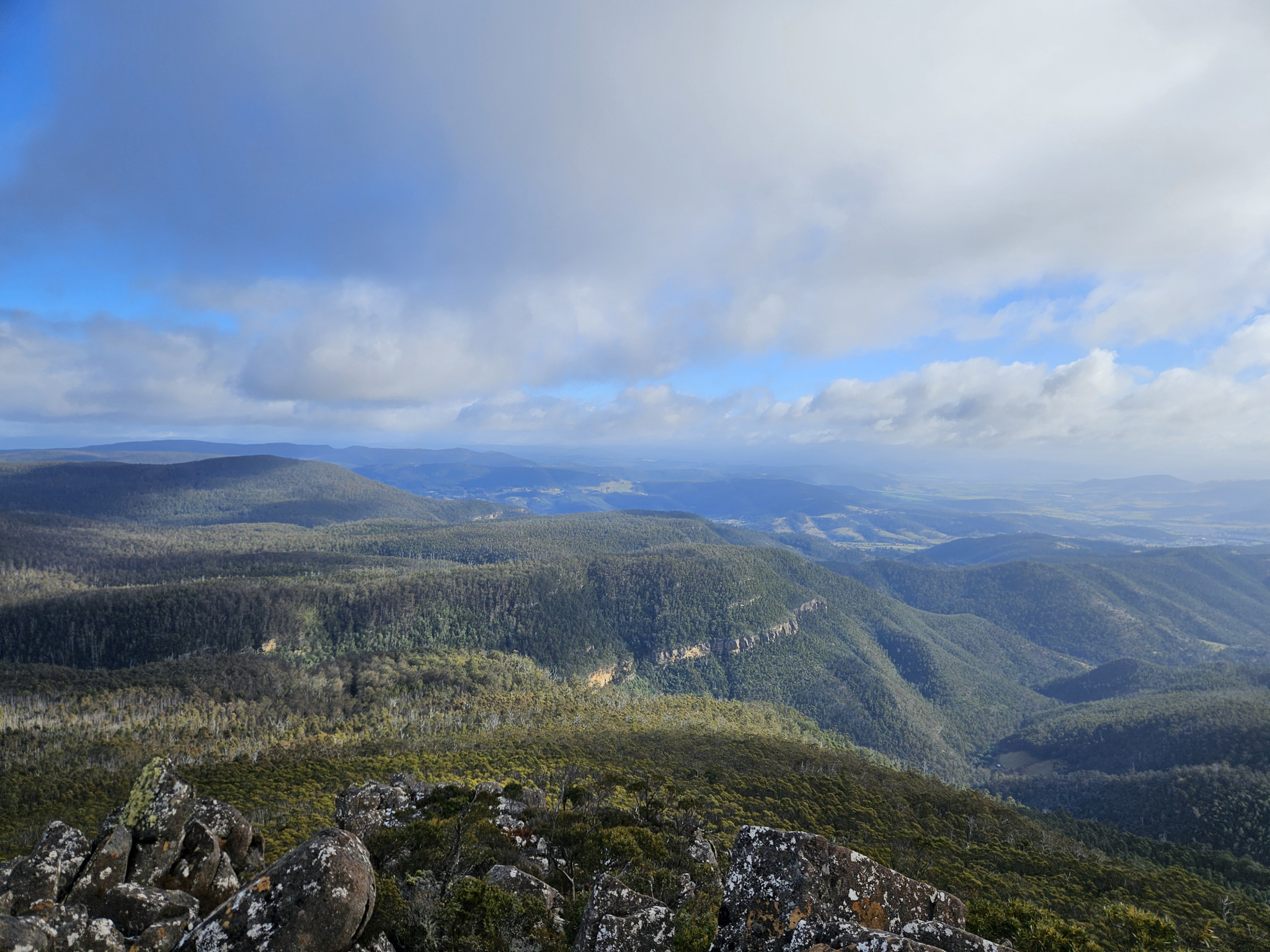
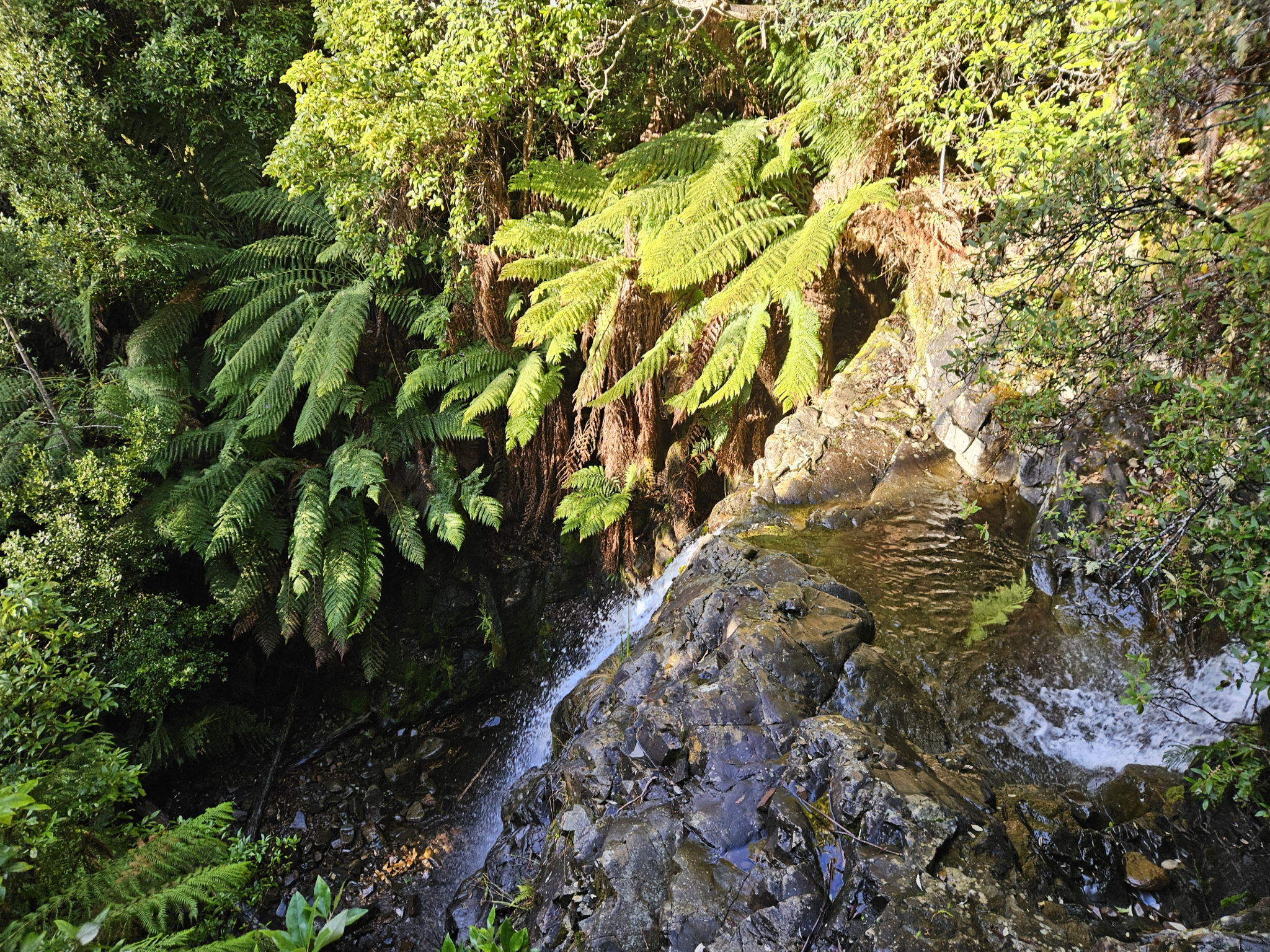
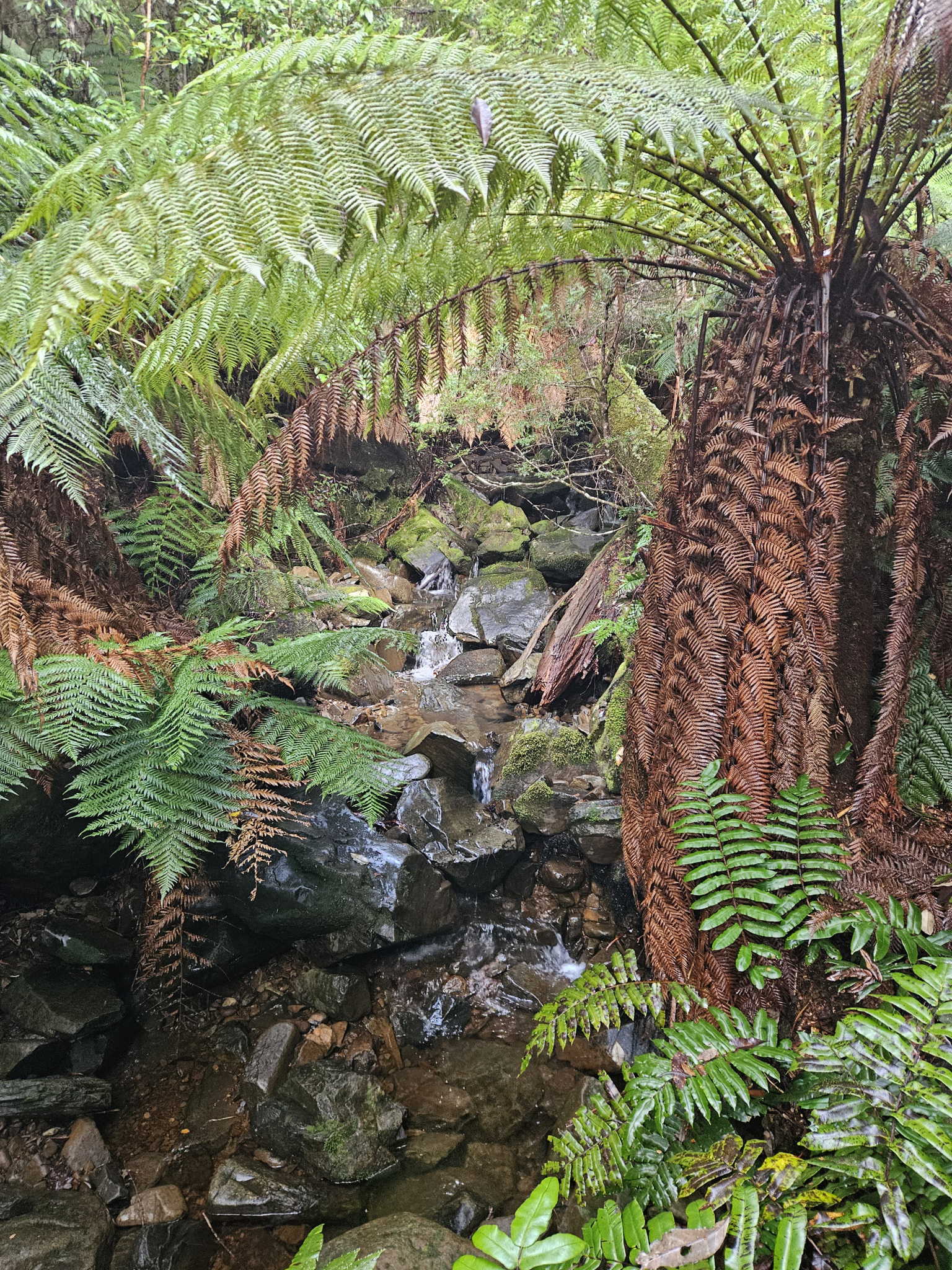
Awesome views from Collins Cap in all directions, especially northward towards the Derwent Valley. Another highlight is the cool temperate rainforest flora lining the track close to the creek on the way up, including Myrtle beech (Nothofagus cunninghamii), Sassafras (Atherosperma moschatum) and tree ferns (Dicksonia antarctica), amongst other species. Eucalyptus regnans, the worlds tallest flowering plant, are also present along the trail.
Nature
Park size: 18,011 hectares
Natural features
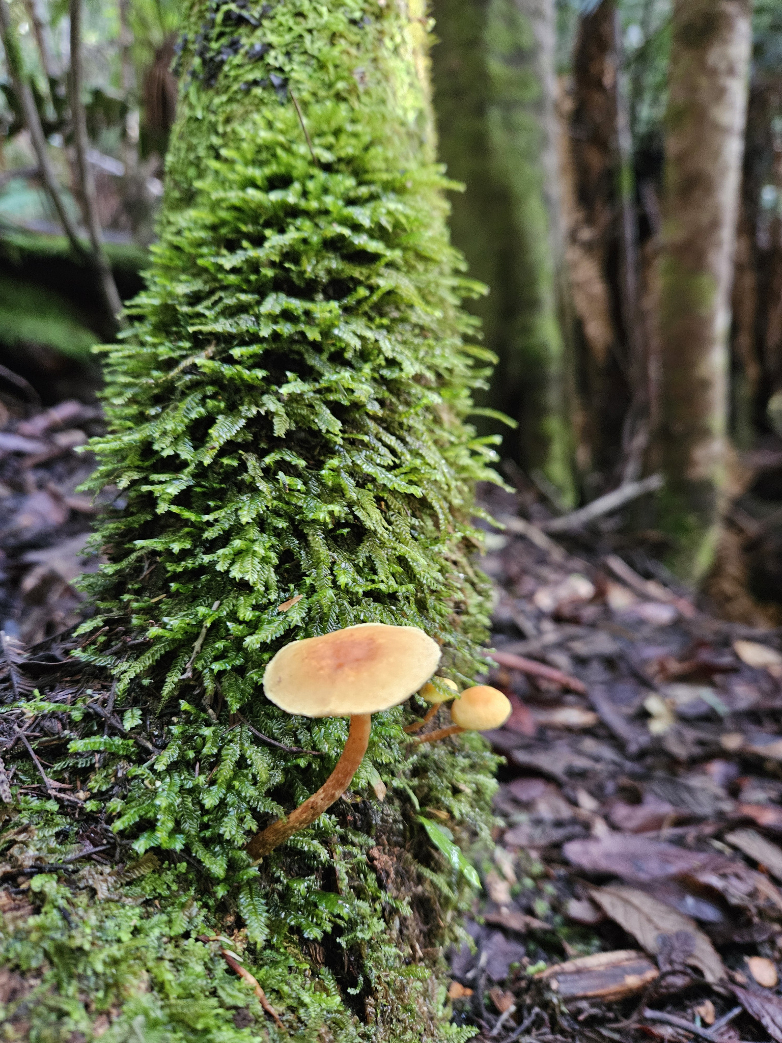
Varied flora including Mountain ash (Eucalyptus regnans), the endemic Urn gum (Eucalyptus urnigera), Myrtle beech (Nothofagus cunninghamii), Sassafras (Atherosperma moschatum) and tree ferns (Dicksonia antarctica), as well as Tasmanian pademelon (Thylogale billardierrii), various bird species, and fungi during the wetter months.
Conservation
Kunanyi/Mt Wellington is a known breeding ground for the critically endangered Swift Parrot (Lathamus discolor) and is also home to the endangered Tasmanian Masked Owl (Tyto novaehollandiae castanops), Wedge-tailed Eagle (Aquila audax fleayi) and Tasmanian Devil (Sarcophilus harrisii).
Feral cats are a threat to biodiversity within the park, as are other Introduced species including the Superb Lyrebird (Menura novaehollandiae).
Track details
The walk starts at the car park at the gate towards the end of Myrtle Forest Road. Walk past the gate and continue along the dirt road for around 700 metres. This section of the walk is quite flat. At the end of the dirt road, you will come to a picnic shelter which includes an interpretation sign about the area and a drop toilet. Walk past the shelter and you will come to a signpost with a rough map directing you onto the trail.
The majority of this walk is uphill, climbing 538 metres in elevation gain. As you make your way up the track, for the most part you will be following Myrtle Creek, and be surrounded by lush, cool temperate rainforest, with surrounding species including the Myrtle beech (Nothofagus cunninghamii), which gives the forest its name.
Keep an eye out for Pademelon (Thylogale billardierrii), which can sometimes be seen hopping through the undergrowth, and the towering Mountain ash (Eucalyptus regnans), the worlds tallest flowering plant, which can be seen along the trail.
As the trail is in a valley and experiences little sun light, the track can often be wet and somewhat slippery, requiring extra care, especially on sections with tree roots or rocks on the track.
After walking for around 1km (approximately 15-20 minutes), you will reach the beautiful Myrtle Creek Waterfall. Here, there is a small viewing platform, which makes a good place to have a rest and take in your surroundings.
Continue making your way up the track. Once you have walked around 1.44km, there is a small creek crossing, requiring care on the slippery rocks. While this is generally an easy crossing, if there has been extremely heavy rain and the creek has flooded, walkers should not attempt to cross this point and should turn back.
A little further on there is a second creek crossing, and then at around 1.71km into your walk you will reach a Y intersection on the track, with signposts directing you to either Collins Bonnet to the left, or Collins Cap to the right. For this walk, take the right hand trail.
Around this point you will begin to make your way out of the valley, leaving the creek and the rainforest flora behind, making your way into sub alpine territory. During the colder months, it is shortly after this point that encountering snow becomes more likely.
At around 2.33km into your walk, you will reach Collins Cap Fire Trail. There will be a sign post directing you to take a left-hand turn. After walking around 20 metres, you will see the track continue again on the other side of the fire trail, leading up the hill with another sign. Take this turnoff.
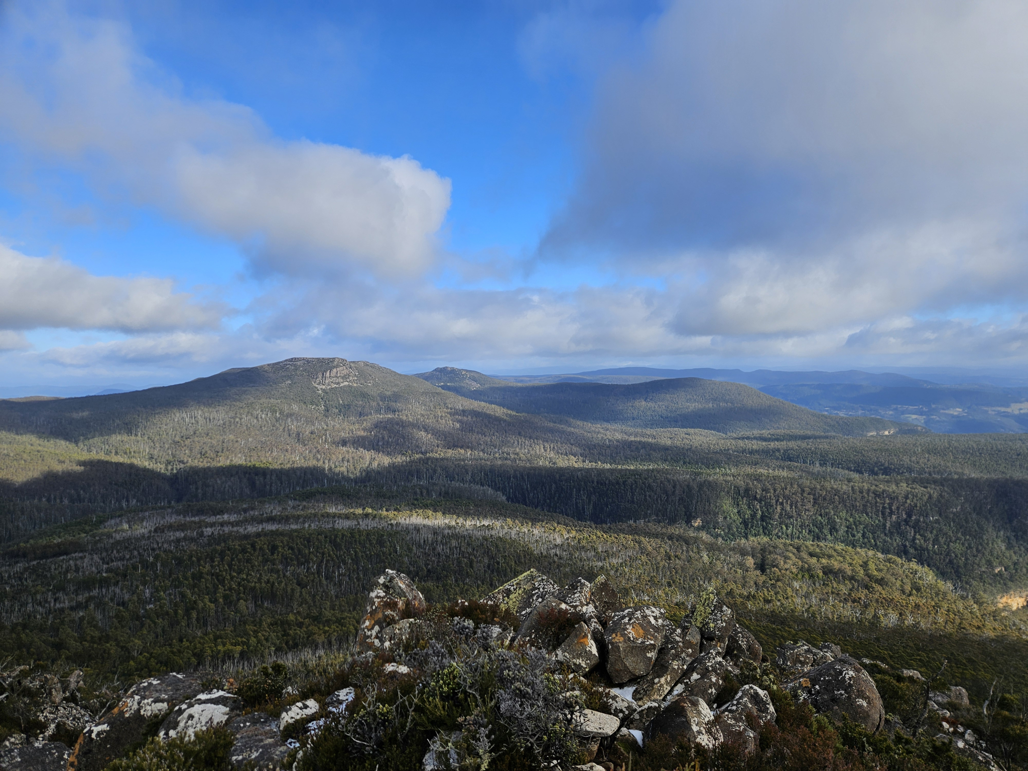
From this point onwards, you will begin to have views looking bak out over Collins Bonnet and the other surrounding peaks.
This section of the walk is dominated by the endemic Urn gum (Eucalyptus urnigera), however, there is also evidence of bushfires in the area, with dead trees peppering the surrounding forest.
As you make your way up the hill, the trail becomes more and more rocky, with sections requiring some scrambling. This section requires extra caution during cold weather, as it will often be either covered in frost, ice or snow, making it very slippery.
Shortly before reaching the summit, the track becomes quite steep, leading you to the summit of Collins Bonnett. There is a circular, rock cairn on the summit, which makes a good spot to sit behind during windy weather.
At the summit, enjoy the views looking out over the Derwent Valley, as well as out over the other peaks and regions of the Wellington Range.
Once you are ready to leave, start making your way back the way you came. Extra care is required when heading back, as it is quite easy to slip on several of the steep and rocky sections, as well as anywhere that has become muddy due to rain or melting snow.
Conditions
This walk is extremely exposed to the weather, with strong winds, freezing temperatures, snow and rain occurring regularly. The trail is often wet, which can be extremely slippery if frozen over, requiring additional care.
While conditions may be fine at the outset of your walk, weather conditions in this section of the park can change rapidly, potentially bringing high winds, rain, and snow, even during summer.
Check local weather forecasts before attempting any walks in Wellington Park. Also be aware that roads may be closed on certain days during winter due to icy roads and snow cover.
Ensure you have appropriate sun protection, as UV radiation is stronger in high altitude areas, such as on mountains. The fire danger rating for the area should also be checked. Be aware that Wellington Park is closed on days with a fire danger rating of Extreme or Catastrophic in the Upper Derwent Valley or Southeast districts.
For up to date weather forecasting on Kunanyi/Mount Wellington, refer to: http://www.bom.gov.au/tas/forecasts/mtwellington.shtml
Safety advice
The upper section of this trail is extremely exposed to the elements and should not be attempted during storms, blizzards or other adverse weather events.
Ensure you are appropriately prepared for mountain weather conditions, and have warm clothing, a waterproof jacket, sturdy walking boots, and food and water.
Weather conditions can change rapidly within the area, with freezing temperatures occurring regularly. The upper section of the track will often be covered in ice during the colder months, and caution should be taken when navigating this section to avoid injury.
For safety purposes, ensure you have told at least two people which walk you are completing.
Hikers should also be aware of the possibility of bushfires as this is a forested environment.
During spring, summer and autumn, be aware that snakes may be active in the area. If encountered, move away from them slowly.
If you are injured and require emergency medical attention, call 000.
For further information on bushfires in Tasmania, refer to: https://www.fire.tas.gov.au/
Age restrictions and advice
This walk is quite steep the whole way, and is not recommended for very young children.
Location
79 Myrtle Forest Road, Collinsvale Tasmania 7012, Australia
From central Hobart, head east along Macquarie Street (A6), before heading North along the Brooker Highway (National Highway 1).
From the Macquarie Street/Brooker Highway turnoff, continue approximately 10.4km before taking the Berridale Road (C615) exit to the left (west). Take the first exit at the roundabout at the bottom of the hill after the exit on to Berridale Road (C615).
Follow Berridale Road, continuing straight onto Glenlusk Road and then Collinsvale Road. After around 9.5km from the Brooker Highway exit, you will make a left hand turn onto Springdale Road. Follow Springdale Road for another 2.7km, before turning left again on to Myrtle Forest Road. This last stretch of road is unsealed. Follow Myrtle Forest Road for a little over 1km, where you will find a small car park and a metal gate. This is the beginning of the walk.
Nature
Park size: 18,011 hectares
Natural features
Varied flora including Mountain ash (Eucalyptus regnans), the endemic Urn gum (Eucalyptus urnigera), Myrtle beech (Nothofagus cunninghamii), Sassafras (Atherosperma moschatum) and tree ferns (Dicksonia antarctica), as well as Tasmanian pademelon (Thylogale billardierrii), various bird species, and fungi during the wetter months.
Conservation
Kunanyi/Mt Wellington is a known breeding ground for the critically endangered Swift Parrot (Lathamus discolor) and is also home to the endangered Tasmanian Masked Owl (Tyto novaehollandiae castanops), Wedge-tailed Eagle (Aquila audax fleayi) and Tasmanian Devil (Sarcophilus harrisii).
Feral cats are a threat to biodiversity within the park, as are other Introduced species including the Superb Lyrebird (Menura novaehollandiae).
Track details
The walk starts at the car park at the gate towards the end of Myrtle Forest Road. Walk past the gate and continue along the dirt road for around 700 metres. This section of the walk is quite flat. At the end of the dirt road, you will come to a picnic shelter which includes an interpretation sign about the area and a drop toilet. Walk past the shelter and you will come to a signpost with a rough map directing you onto the trail.
The majority of this walk is uphill, climbing 538 metres in elevation gain. As you make your way up the track, for the most part you will be following Myrtle Creek, and be surrounded by lush, cool temperate rainforest, with surrounding species including the Myrtle beech (Nothofagus cunninghamii), which gives the forest its name.
Keep an eye out for Pademelon (Thylogale billardierrii), which can sometimes be seen hopping through the undergrowth, and the towering Mountain ash (Eucalyptus regnans), the worlds tallest flowering plant, which can be seen along the trail.
As the trail is in a valley and experiences little sun light, the track can often be wet and somewhat slippery, requiring extra care, especially on sections with tree roots or rocks on the track.
After walking for around 1km (approximately 15-20 minutes), you will reach the beautiful Myrtle Creek Waterfall. Here, there is a small viewing platform, which makes a good place to have a rest and take in your surroundings.
Continue making your way up the track. Once you have walked around 1.44km, there is a small creek crossing, requiring care on the slippery rocks. While this is generally an easy crossing, if there has been extremely heavy rain and the creek has flooded, walkers should not attempt to cross this point and should turn back.
A little further on there is a second creek crossing, and then at around 1.71km into your walk you will reach a Y intersection on the track, with signposts directing you to either Collins Bonnet to the left, or Collins Cap to the right. For this walk, take the right hand trail.
Around this point you will begin to make your way out of the valley, leaving the creek and the rainforest flora behind, making your way into sub alpine territory. During the colder months, it is shortly after this point that encountering snow becomes more likely.
At around 2.33km into your walk, you will reach Collins Cap Fire Trail. There will be a sign post directing you to take a left-hand turn. After walking around 20 metres, you will see the track continue again on the other side of the fire trail, leading up the hill with another sign. Take this turnoff.
From this point onwards, you will begin to have views looking bak out over Collins Bonnet and the other surrounding peaks.
This section of the walk is dominated by the endemic Urn gum (Eucalyptus urnigera), however, there is also evidence of bushfires in the area, with dead trees peppering the surrounding forest.
As you make your way up the hill, the trail becomes more and more rocky, with sections requiring some scrambling. This section requires extra caution during cold weather, as it will often be either covered in frost, ice or snow, making it very slippery.
Shortly before reaching the summit, the track becomes quite steep, leading you to the summit of Collins Bonnett. There is a circular, rock cairn on the summit, which makes a good spot to sit behind during windy weather.
At the summit, enjoy the views looking out over the Derwent Valley, as well as out over the other peaks and regions of the Wellington Range.
Once you are ready to leave, start making your way back the way you came. Extra care is required when heading back, as it is quite easy to slip on several of the steep and rocky sections, as well as anywhere that has become muddy due to rain or melting snow.
Conditions
This walk is extremely exposed to the weather, with strong winds, freezing temperatures, snow and rain occurring regularly. The trail is often wet, which can be extremely slippery if frozen over, requiring additional care.
While conditions may be fine at the outset of your walk, weather conditions in this section of the park can change rapidly, potentially bringing high winds, rain, and snow, even during summer.
Check local weather forecasts before attempting any walks in Wellington Park. Also be aware that roads may be closed on certain days during winter due to icy roads and snow cover.
Ensure you have appropriate sun protection, as UV radiation is stronger in high altitude areas, such as on mountains. The fire danger rating for the area should also be checked. Be aware that Wellington Park is closed on days with a fire danger rating of Extreme or Catastrophic in the Upper Derwent Valley or Southeast districts.
For up to date weather forecasting on Kunanyi/Mount Wellington, refer to: http://www.bom.gov.au/tas/forecasts/mtwellington.shtml
Safety advice
The upper section of this trail is extremely exposed to the elements and should not be attempted during storms, blizzards or other adverse weather events.
Ensure you are appropriately prepared for mountain weather conditions, and have warm clothing, a waterproof jacket, sturdy walking boots, and food and water.
Weather conditions can change rapidly within the area, with freezing temperatures occurring regularly. The upper section of the track will often be covered in ice during the colder months, and caution should be taken when navigating this section to avoid injury.
For safety purposes, ensure you have told at least two people which walk you are completing.
Hikers should also be aware of the possibility of bushfires as this is a forested environment.
During spring, summer and autumn, be aware that snakes may be active in the area. If encountered, move away from them slowly.
If you are injured and require emergency medical attention, call 000.
For further information on bushfires in Tasmania, refer to: https://www.fire.tas.gov.au/
Age restrictions and advice
This walk is quite steep the whole way, and is not recommended for very young children.
Location
79 Myrtle Forest Road, Collinsvale Tasmania 7012, Australia
From central Hobart, head east along Macquarie Street (A6), before heading North along the Brooker Highway (National Highway 1).
From the Macquarie Street/Brooker Highway turnoff, continue approximately 10.4km before taking the Berridale Road (C615) exit to the left (west). Take the first exit at the roundabout at the bottom of the hill after the exit on to Berridale Road (C615).
Follow Berridale Road, continuing straight onto Glenlusk Road and then Collinsvale Road. After around 9.5km from the Brooker Highway exit, you will make a left hand turn onto Springdale Road. Follow Springdale Road for another 2.7km, before turning left again on to Myrtle Forest Road. This last stretch of road is unsealed. Follow Myrtle Forest Road for a little over 1km, where you will find a small car park and a metal gate. This is the beginning of the walk.