
A lovely short walk at the base of Kunanyi that is easily accessible, perfect for stretching the legs or as an access route to other trails on the mountain.
Highlights
Bubbling streams with stone bridges, varying flora and fauna and easy access to nature.
Nature
Natural features
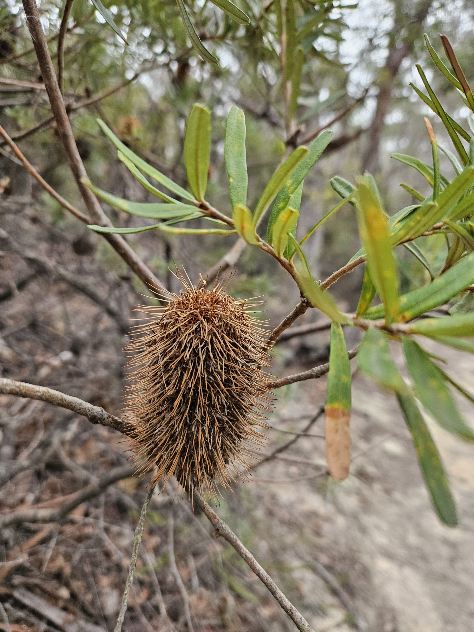
Tasmanian native cherry (Exocarpos cupressiformis), Silver banksia (Banksia marginata) Ferns, fungi, dry sclerophyll, Bennetts wallaby (Notamacropus rufogriseus), Tasmanian pademelon (Thylogale billardierii), Grey fantail (Rhipidura albiscapa) and the Green rosella (Platycercus caledonicus, amongst many other species of flora and fauna.
Conservation
Kunanyi/Mt Wellington is a known breeding ground for the critically endangered Swift Parrot (Lathamus discolor) and is also home to the endangered Tasmanian Masked Owl (Tyto novaehollandiae castanops), Wedge-tailed Eagle (Aquila audax fleayi) and Tasmanian Devil (Sarcophilus harrisii).
Feral cats are a threat to biodiversity within the park, as are other Introduced species including the Superb Lyrebird (Menura novaehollandiae).
Track details
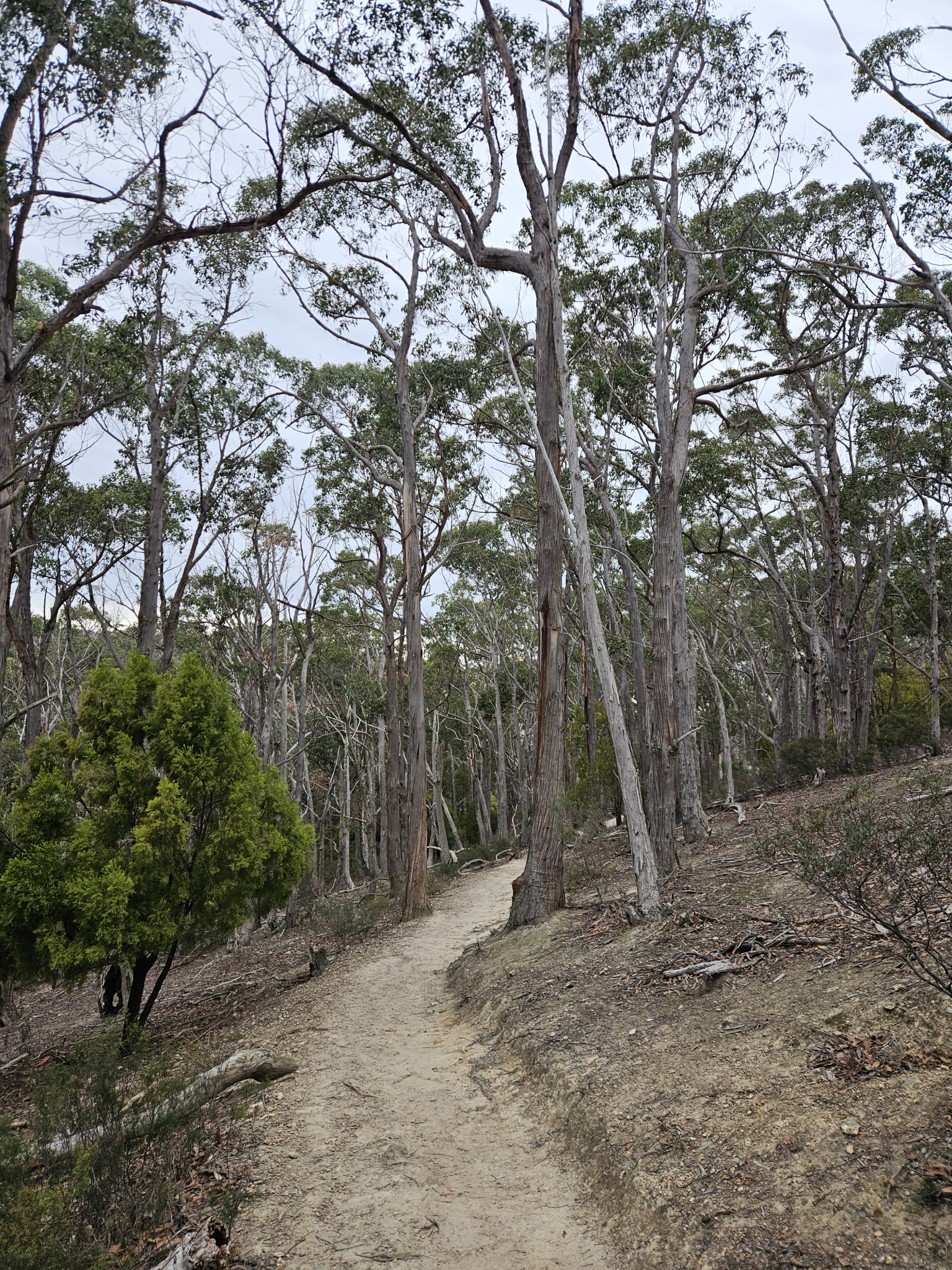
After parking your car, walk 100 metres down the hill and across Old Farm Road. You will see a signpost that directs you to the start of the Cascade Track, which heads off to the right up the hill into the forest. From here, the first section of the trail is relatively flat, as you make your way through the dry sclerophyll forest. Distinctive flora along this part of the trail includes Tasmanian native cherry (Exocarpos cupressiformis), Silver banksia (Banksia marginata) and several species of wattle and eucalyptus.
Due to the forest being less dense along this section of the track, you have a better chance of seeing local wildlife including the Bennetts wallaby (Notamacropus rufogriseus) and the Tasmanian pademelon (Thylogale billardierii), as well as bird species such as the Grey fantail (Rhipidura albiscapa) and Green rosella (Platycercus caledonicus).
Along this track, there are several other trails that cross the Cascade Track. To remain on the Cascade Track, continue walking straight ahead rather than making any turns at these intersections. At several of the intersections, there will be signposts directing you along the trail towards Wellington Park. Follow these markers. Walkers should also be aware that some of the trails that intersect the main path are mountain bike tracks, and walkers should therefore check it is all clear before crossing.
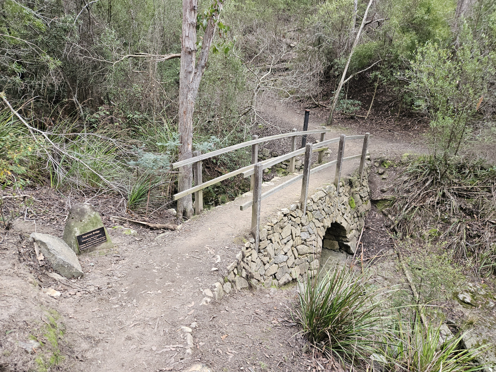
After walking just under 1km you will come Degraves Bridge. This stone, arched bridge was built in honor of Peter Degraves, who founded the Cascade Brewery which you will have passed at the beginning of the walk.
Cross the bridge and then follow the signpost to Wellington Park, making your way up the hill along the stony steps. A little further along the track, you will come to another trail intersection. The intersecting track is a mountain bike path. After checking it is safe to cross, continue along the trail.
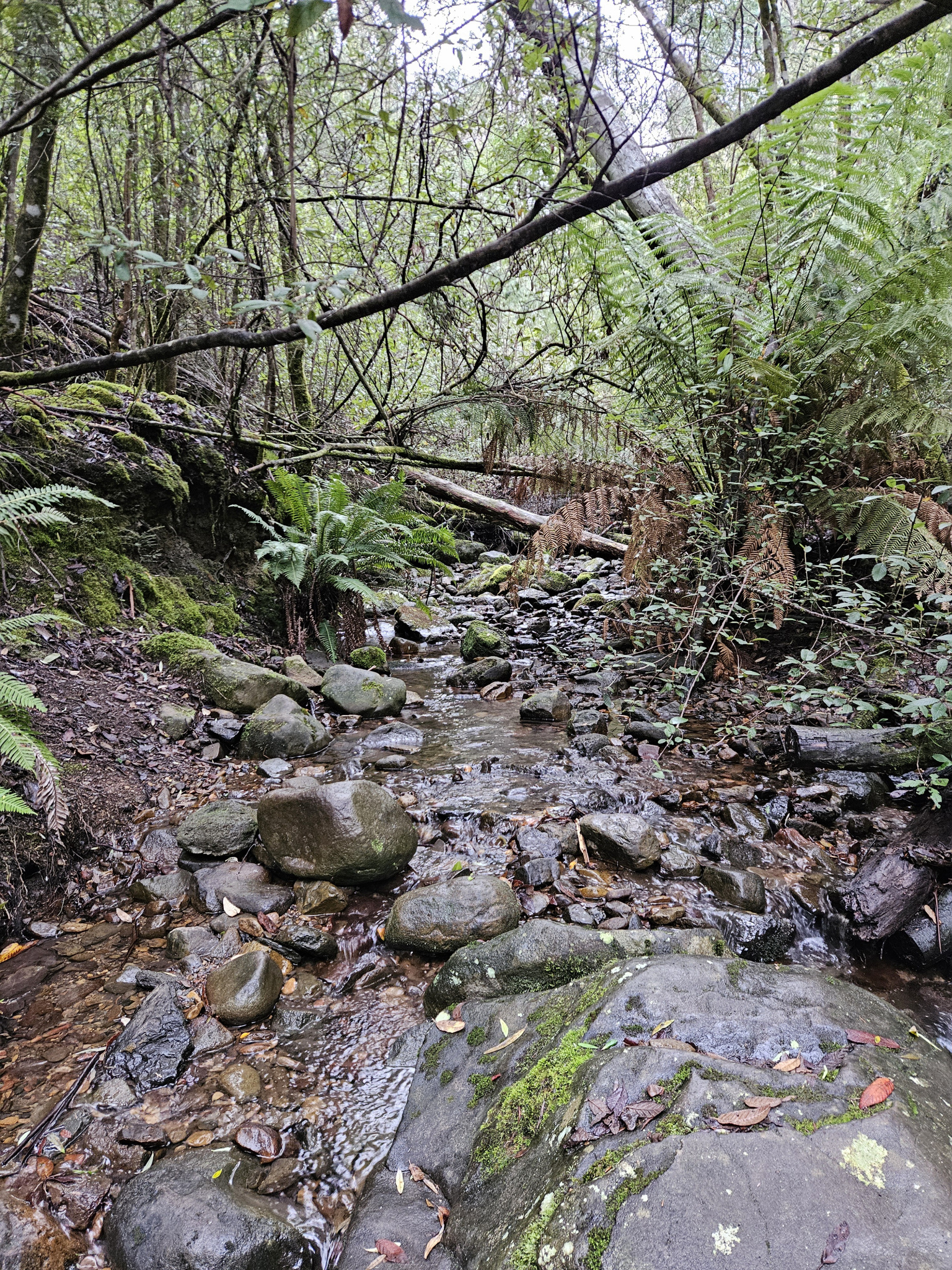
As you make your way up the track, the flora gradually becomes wetter, with several fern species lining the trail, and moss covering the surrounding rocks. The track works its way gradually up the hill, before eventually finishing at the beginning of the Main Fire Trail at the top of Old Farm Road.
From this point, if you are returning after completing the Cascade Track, make your way back the way you came. If you wish to continue walking further, a short distance to your left, several other trails including the Myrtle Gully Track begin. If you are continuing to one of these trails, refer to their respective guides for further information.
Conditions
While this walk is located at the base of Kunanyi, conditions can still change rapidly, and it will be somewhat cooler here than in the city. If you are venturing further up the mountain there may be high winds, rain, and snow, even in summer. Check local weather forecasts before attempting any walks in Wellington Park.
Ensure you have appropriate sun protection. The fire danger rating for the area should also be checked. Be aware that Wellington Park is closed on days with a fire danger rating of Extreme or Catastrophic in the Upper Derwent Valley or Southeast districts.
For up to date weather forecasting on South Hobart, please refer to:
http://www.bom.gov.au/places/tas/south-hobart/
For up rto dare weather forecasting for Kunanyi/Mount Wellington, refer to:
Safety advice
Be aware that after heavy rain, sections of this walk that cross the stream may be impassable due to flooding.
Ensure you are appropriately prepared for the weather conditions with appropriate clothing, a waterproof jacket, walking shoes or boots, and food and water. Be aware that conditions can change rapidly in the area.
Sections of the trail can be slippery after rain, especially the sections that cross or run parallel to the stream.
Hikers should also be aware of the possibility of bushfires as this is a forested environment.
During spring, summer and autumn, be aware that snakes may be active in the area. If encountered, move away from them slowly.
If you are injured and require emergency medical attention, call 000.
For further information on bushfires in Tasmania, refer to: https://www.fire.tas.gov.au/
Age restrictions and advice
This walk is appropriate for all ages.
Location
Old Farm Road, South Hobart Tasmania 7004, Australia
From Hobart, drive Southwest along Davey Street for around 1.3km before turning right at the Southern Outlet intersection. Turn left 100 metres later onto Macquarie Street. Follow Macquarie Street, which then becomes Cascade Road, for another 2.2km, until you come to the Cascade Brewery. There is a carpark at the far side of Cascade brewery in the corner of Cascade Road and Marlyn Road. Park here. The trail starts around 100 metres down the hill at the beginning of Old Farm Road.
Nature
Natural features
Tasmanian native cherry (Exocarpos cupressiformis), Silver banksia (Banksia marginata) Ferns, fungi, dry sclerophyll, Bennetts wallaby (Notamacropus rufogriseus), Tasmanian pademelon (Thylogale billardierii), Grey fantail (Rhipidura albiscapa) and the Green rosella (Platycercus caledonicus, amongst many other species of flora and fauna.
Conservation
Kunanyi/Mt Wellington is a known breeding ground for the critically endangered Swift Parrot (Lathamus discolor) and is also home to the endangered Tasmanian Masked Owl (Tyto novaehollandiae castanops), Wedge-tailed Eagle (Aquila audax fleayi) and Tasmanian Devil (Sarcophilus harrisii).
Feral cats are a threat to biodiversity within the park, as are other Introduced species including the Superb Lyrebird (Menura novaehollandiae).
Track details
After parking your car, walk 100 metres down the hill and across Old Farm Road. You will see a signpost that directs you to the start of the Cascade Track, which heads off to the right up the hill into the forest. From here, the first section of the trail is relatively flat, as you make your way through the dry sclerophyll forest. Distinctive flora along this part of the trail includes Tasmanian native cherry (Exocarpos cupressiformis), Silver banksia (Banksia marginata) and several species of wattle and eucalyptus.
Due to the forest being less dense along this section of the track, you have a better chance of seeing local wildlife including the Bennetts wallaby (Notamacropus rufogriseus) and the Tasmanian pademelon (Thylogale billardierii), as well as bird species such as the Grey fantail (Rhipidura albiscapa) and Green rosella (Platycercus caledonicus).
Along this track, there are several other trails that cross the Cascade Track. To remain on the Cascade Track, continue walking straight ahead rather than making any turns at these intersections. At several of the intersections, there will be signposts directing you along the trail towards Wellington Park. Follow these markers. Walkers should also be aware that some of the trails that intersect the main path are mountain bike tracks, and walkers should therefore check it is all clear before crossing.
After walking just under 1km you will come Degraves Bridge. This stone, arched bridge was built in honor of Peter Degraves, who founded the Cascade Brewery which you will have passed at the beginning of the walk.
Cross the bridge and then follow the signpost to Wellington Park, making your way up the hill along the stony steps. A little further along the track, you will come to another trail intersection. The intersecting track is a mountain bike path. After checking it is safe to cross, continue along the trail.
As you make your way up the track, the flora gradually becomes wetter, with several fern species lining the trail, and moss covering the surrounding rocks. The track works its way gradually up the hill, before eventually finishing at the beginning of the Main Fire Trail at the top of Old Farm Road.
From this point, if you are returning after completing the Cascade Track, make your way back the way you came. If you wish to continue walking further, a short distance to your left, several other trails including the Myrtle Gully Track begin. If you are continuing to one of these trails, refer to their respective guides for further information.
Conditions
While this walk is located at the base of Kunanyi, conditions can still change rapidly, and it will be somewhat cooler here than in the city. If you are venturing further up the mountain there may be high winds, rain, and snow, even in summer. Check local weather forecasts before attempting any walks in Wellington Park.
Ensure you have appropriate sun protection. The fire danger rating for the area should also be checked. Be aware that Wellington Park is closed on days with a fire danger rating of Extreme or Catastrophic in the Upper Derwent Valley or Southeast districts.
For up to date weather forecasting on South Hobart, please refer to:
http://www.bom.gov.au/places/tas/south-hobart/
For up rto dare weather forecasting for Kunanyi/Mount Wellington, refer to:
Safety advice
Be aware that after heavy rain, sections of this walk that cross the stream may be impassable due to flooding.
Ensure you are appropriately prepared for the weather conditions with appropriate clothing, a waterproof jacket, walking shoes or boots, and food and water. Be aware that conditions can change rapidly in the area.
Sections of the trail can be slippery after rain, especially the sections that cross or run parallel to the stream.
Hikers should also be aware of the possibility of bushfires as this is a forested environment.
During spring, summer and autumn, be aware that snakes may be active in the area. If encountered, move away from them slowly.
If you are injured and require emergency medical attention, call 000.
For further information on bushfires in Tasmania, refer to: https://www.fire.tas.gov.au/
Age restrictions and advice
This walk is appropriate for all ages.
Location
Old Farm Road, South Hobart Tasmania 7004, Australia
From Hobart, drive Southwest along Davey Street for around 1.3km before turning right at the Southern Outlet intersection. Turn left 100 metres later onto Macquarie Street. Follow Macquarie Street, which then becomes Cascade Road, for another 2.2km, until you come to the Cascade Brewery. There is a carpark at the far side of Cascade brewery in the corner of Cascade Road and Marlyn Road. Park here. The trail starts around 100 metres down the hill at the beginning of Old Farm Road.
Key info
1-1.5 hours return
4.78km return
Grade 1: Easy
Facilities
While dogs are permitted on the trail, please ensure they are on a leash at all times, as there are native species in the area such as the Bennetts wallaby and the Tasmanian pademelon that they may chase or frighten.