
A paddle starting in the sheltered East Cove and running close to the rocky shoreline fringed by coastal forest, heading out to Grass Point and Penguin Island.
Highlights
Spectacular views looking back over Adventure Bay and north towards Cape Queen Elizabeth.
Nature
Natural features
This paddle offers wonderful views back along Adventure Bay and out to Cape Queen Elizabeth, and southern right whales can sometimes be spotted in the area during migration, which is between June to late October. Various sea birds can often be spotted on this paddle including white-bellied sea eagles, and various types of cormorants, oystercatches and gulls.
Track details
From the carpark, there is a short track down to East Cove beach where you can carry your Kayak out to put it into the water. While East Cove is usually quite sheltered, there can be a small surging wave on the beach. Once you have launched, paddle to the eastern end of the beach and then follow the rocky Eucalypt and casuarina fringed shoreline north to make your way out to Grass Point. There are a few pebble beaches that can be landed on along the way, however, depending on swell size and direction, there can be large surges on this coastline that can make landing difficult.
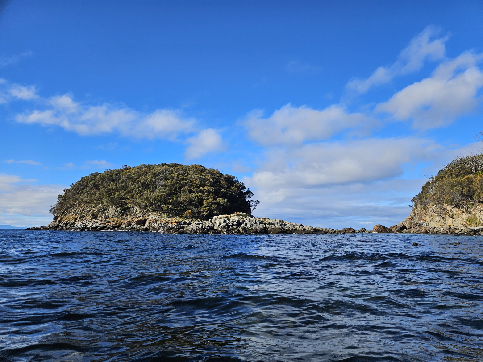
Once you have reached the end of the bay, you will have a view of Grass Point and Penguin Island, with a strip of rocks running between Grass Point and Penguin Island. Depending on the swell size and direction, significant surges can make their way through this gap, and you should only approach this area after watching it for some time and ensuring it is safe to do so. Generally, it is not possible to paddle through this gap due to the rocks present. Once you have taken in the views, begin to make your way back along the coastline towards East Cove.
If you would like to extend your paddle further, two good options are to head over to either the Captains Cook Creek Trail, which is 1.6km west along the coast from the put in point, or over to the Quiet Corner – Coal Point Trail which is a further 1.6km along the beach from Cooks Creek. For further information, refer to the relevant trail guides.
History
Cultural and historical values
This is a historical and culturally significant area, and The Nuenonne people frequented this coastline and made it home for more than 40,000 years. Adventure Bay also has relevence to Tasmania's European exploratory and colonial history, with Abel Tasman landing in the bay in 1642, and Captain James Cook landing here in 1777, signalling the start of great turmoil for the land’s first peoples.
Conditions
Paddling from East Cove close to the shore towards Grass Point is well sheltered from southerly and easterly winds, however, it is completely exposed to northerly winds. It is also quite protected from the ocean swell; however, you will lose this protection if you paddle past Grass Point along the side of Penguin Island.
Safety advice
Potential hazards to be aware of when kayaking include unpredictable wind strengths and directions, capsizing, hypothermia, sunstroke, and drowning. To best prevent these incidents from occurring it is crucial that appropriate safety equipment is used and the kayaker should have a sound understanding of the effects of wind, currents and water temperature in the local area. Prior to undertaking this trip, kayakers should review the local safety equipment requirements and other safety information as outlined by MAST, which can be found here: https://mast.tas.gov.au/safe-b...
While paddling along the coast towards Grass Point is generally quite sheltered, if you choose to paddle further out from Grass Point you will be exposed to the often large swell and harsher conditions of Storm Bay and the Southern Ocean. Paddlers should also be cautious if approaching the rocks that run between Penguin Island and Grass Point, as large surges can rush through here, making it important that you watch what the water is doing for some time before approaching.
Age restrictions and advice
Children should be accompanied by an adult on this trail.
Location
998 Adventure Bay Road, Adventure Bay Tasmania 7150, Australia
Drive south through Adventure Bay along Adventure Bay Road (C630) until you reach the Fluted Cape carpark (next to Bruny Island Cruises and Seafood Restaurant). Unload your kayak using a boat trailer carpark as they are closest to the beach, before moving your vehicle to a regular carpark.
Nature
Natural features
This paddle offers wonderful views back along Adventure Bay and out to Cape Queen Elizabeth, and southern right whales can sometimes be spotted in the area during migration, which is between June to late October. Various sea birds can often be spotted on this paddle including white-bellied sea eagles, and various types of cormorants, oystercatches and gulls.
Track details
From the carpark, there is a short track down to East Cove beach where you can carry your Kayak out to put it into the water. While East Cove is usually quite sheltered, there can be a small surging wave on the beach. Once you have launched, paddle to the eastern end of the beach and then follow the rocky Eucalypt and casuarina fringed shoreline north to make your way out to Grass Point. There are a few pebble beaches that can be landed on along the way, however, depending on swell size and direction, there can be large surges on this coastline that can make landing difficult.
Once you have reached the end of the bay, you will have a view of Grass Point and Penguin Island, with a strip of rocks running between Grass Point and Penguin Island. Depending on the swell size and direction, significant surges can make their way through this gap, and you should only approach this area after watching it for some time and ensuring it is safe to do so. Generally, it is not possible to paddle through this gap due to the rocks present. Once you have taken in the views, begin to make your way back along the coastline towards East Cove.
If you would like to extend your paddle further, two good options are to head over to either the Captains Cook Creek Trail, which is 1.6km west along the coast from the put in point, or over to the Quiet Corner – Coal Point Trail which is a further 1.6km along the beach from Cooks Creek. For further information, refer to the relevant trail guides.
History
Cultural and historical values
This is a historical and culturally significant area, and The Nuenonne people frequented this coastline and made it home for more than 40,000 years. Adventure Bay also has relevence to Tasmania's European exploratory and colonial history, with Abel Tasman landing in the bay in 1642, and Captain James Cook landing here in 1777, signalling the start of great turmoil for the land’s first peoples.
Conditions
Paddling from East Cove close to the shore towards Grass Point is well sheltered from southerly and easterly winds, however, it is completely exposed to northerly winds. It is also quite protected from the ocean swell; however, you will lose this protection if you paddle past Grass Point along the side of Penguin Island.
Safety advice
Potential hazards to be aware of when kayaking include unpredictable wind strengths and directions, capsizing, hypothermia, sunstroke, and drowning. To best prevent these incidents from occurring it is crucial that appropriate safety equipment is used and the kayaker should have a sound understanding of the effects of wind, currents and water temperature in the local area. Prior to undertaking this trip, kayakers should review the local safety equipment requirements and other safety information as outlined by MAST, which can be found here: https://mast.tas.gov.au/safe-b...
While paddling along the coast towards Grass Point is generally quite sheltered, if you choose to paddle further out from Grass Point you will be exposed to the often large swell and harsher conditions of Storm Bay and the Southern Ocean. Paddlers should also be cautious if approaching the rocks that run between Penguin Island and Grass Point, as large surges can rush through here, making it important that you watch what the water is doing for some time before approaching.
Age restrictions and advice
Children should be accompanied by an adult on this trail.
Location
998 Adventure Bay Road, Adventure Bay Tasmania 7150, Australia
Drive south through Adventure Bay along Adventure Bay Road (C630) until you reach the Fluted Cape carpark (next to Bruny Island Cruises and Seafood Restaurant). Unload your kayak using a boat trailer carpark as they are closest to the beach, before moving your vehicle to a regular carpark.
Key info
1-1.5 hours return
4.4km return
Grade 2: Moderate